11:40 AM | *Cold air intrusion into the eastern US in early October following re-curvature of western Pacific typhoon…Hurricane Rosa could impact the Southwest US later next week*
Paul Dorian

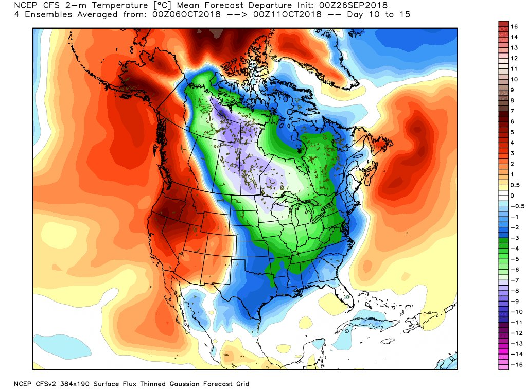
NOAA’s CFS forecast maps of 2-meter temperature anomalies feature colder-than-normal conditions across Canada during days 5-10 and then in the central and eastern US by days 10-15; maps courtesy NOAA, Weather Bell Analytics
Overview
There has been plenty of unseasonably cold air across Canada in recent weeks and it looks like it will stay bottled up there for another several days. However, an overall pattern change may develop in coming days that involves a typhoon in the western Pacific and this could result in an impressive shot of cold air for the eastern US in about ten days to two weeks. Another tropical system that has formed in the eastern Pacific may have a significant impact on the Southwest US later next week.
Typhoon Trami (western Pacific)

Latest colorized infrared satellite imagery loop of Typhoon Trami in the western Pacific. This tropical system may actually set off a chain of events in the atmosphere that will bring cold air for this time of year into the central and eastern US during early October. Courtesy University of Wisconsin/CIMMS
Typhoon Trami is way out there in the western Pacific around 340 miles south of Okinawa, Japan and is currently tracking to the north-to-northeast. It is equivalent to a category 3 hurricane in the Atlantic (i.e., major) and will remain over the open ocean though tomorrow. After that, Trami is likely to accelerate towards Japan’s Ryukyu Islands and eventually head out into the open waters of the northern Pacific Ocean.
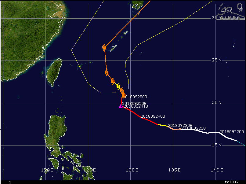
Typhoon Trami will head towards Japan in coming days; courtesy Wisconsin/CIMMS
With this “re-curvature” track, Trami is likely to set off an upper-level pattern change that often results in a deep trough over the eastern US in about ten days to two weeks. As such, the cold air that has been bottled up in Canada in recent weeks may finally have a means to drop southeastward into the eastern US – perhaps by the end of next week or shortly thereafter.

Hurricane Rosa may eventually have an impact in the Southwest US including perhaps southern California; courtesy NOAA
Hurricane Rosa (eastern Pacific)
Meanwhile, in the eastern Pacific Ocean, Hurricane Rosa has formed and is undergoing rapid intensification. Rosa should continue in this strengthening trend over the next couple of days and then it’ll begin a curvature pattern much like Typhoon Trami with a turn to the northwest and then ultimately to the north and northeast. As such, Hurricane Rosa will threaten Baja California early next week and ultimately it could actually impact significantly the Southwest US including southern California and Arizona with copious amounts of moisture.
Meteorologist Paul Dorian
Perspecta, Inc.
perspectaweather.com