
1:45 PM | *Dramatic temperature drops out west with unusual early season cold and accumulating snow…powerful Atlantic storm pounding away at southern New England*
Paul Dorian
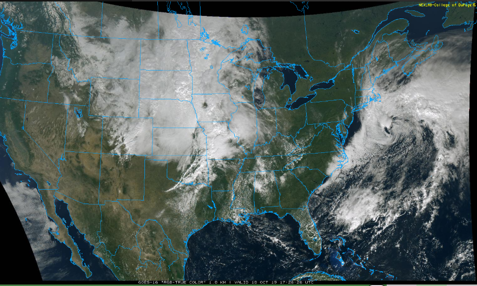
An active pattern across the US is resulting in a powerful storm in the Rockies and another off the Mid-Atlantic coastline; image courtesy NOAA, College of DuPage
Overview
At this time yesterday, temperatures were in the mid 70’s in Denver, Colorado and the latest observation has quite a difference: 19 degrees, snow and wind gusts to 26 mph. In fact, a few inches of snow has already been reported in the Denver/Boulder Colorado region with significantly higher amounts across Montana which was very hard hit with snow a couple of weeks ago. As this developing storm continues to intensify and pushes off to the northeast over the next couple of days, the “bulls eye” region for snowfall may be eastern North Dakota where more than two feet is possible by early Saturday. Meanwhile, on the other side of the nation, a nor’easter is pounding away at southern New England with heavy rainfall and strong winds.
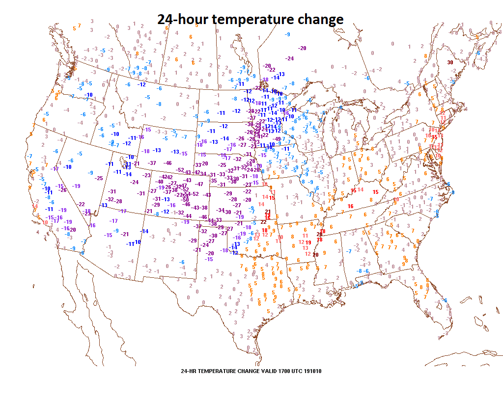
the temperature drop in some spots has been as much as 50 degrees in the 24 hours from this time yesterday to today; map courtesy Penn State ewall
Western/central US cold and snow
A very active weather pattern continues across the US with a record-breaking cold air intrusion into the western US and unusual early season accumulating snow will spread northeast over the next couple of days from the Rockies to the Northern Plains. Daily temperature records have already been set today in in several western states as well as the southwestern part of Canada. In Great Falls, Montana where a foot of snow has fallen, temperatures have dropped to 0 degrees (F) today which is the earliest date in over 130 years of records (prior earliest date for 0 degrees was 10/27 in 1925). As much as two feet of snow has piled up in Pony, Montana and 18 inches in the capital of Helena in the western part of the state. At the end of September, more than 4 feet of snow was recorded in Glacier National Park (Montana).

As this developing western US storm moves to the northeast, significant accumulating snow will pile up from the Rockies to the Northern Plains by the early part of the weekend. More than two feet of snow will be possible from this storm across the Dakotas and there will very likely be some record-breaking cold as well. Courtesy NOAA (12Z NAM-3km), tropical tidbits.com
NW Atlantic storm
Not to be outdone by the news making snow and cold in the western and central US, there is a lot of action going on over the northwestern Atlantic Ocean. Two low pressure systems are in the process of merging into one powerful storm system over the northwestern Atlantic and this storm will pound away on southern New England over the next 24-26 hours or so. A long duration event will impact coastal sections of Massachusetts, Rhode Island and eastern Connecticut through tomorrow with half a foot of rainfall possible in some of that region to go along with wind gusts of 50-60 mph. Since this storm is a slow-mover, the heavy rain and strong winds will take place over an extended period of time and this increases the chances for localized flooding, downed tree limbs and power outages. The merged strong low pressure system may just wait until the early part of the weekend to be pushed farther out-to-sea by an eastward moving N-S oriented cold front.
Meteorologist Paul Dorian
Perspecta, Inc.
perspectaweather.com