
3:00 PM | *Coast-to-coast weather problems this week…tremendous cold and snow from the Northern Rockies to Northern Plains…strong storm meanders over the NW Atlantic to impact the Mid-Atlantic/NE US*
Paul Dorian

A tremendous shot of cold air coming to much of the western and central US later this week; courtesy NOAA, tropicaltidbits.com
Overview
The month of October has seen above-normal snowfall across the Northern Hemisphere in recent years and there is likely to be some significant snow accumulations later this week in the region from the Colorado Rockies to the Northern Plains. This snow will be made possible by a tremendous shot of cold air for early October that will bring temperatures down to potential record low levels in the Rockies, central/northern Plains and Great Lakes during the next several days. Meanwhile, low pressure will intensify along a stalled out frontal boundary zone over the NW Atlantic over the next few days and it may impact the Mid-Atlantic/NE US from tomorrow into the end of the work week.
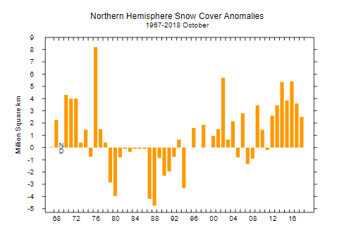
The last several years have seen above-normal snowfall in the Northern Hemisphere during the month of October; courtesy Rutgers Snow Lab
Cold and snow in the western and central US
There was an early season snowstorm in Montana at the end of September associated with a cold trough of low pressure and another impressive cold air shot is headed to much of the same part of the country. Temperatures in Boulder, Colorado could reach the middle 70’s on Wednesday afternoon only to be followed by an Arctic blast on Thursday limiting highs to the 30’s at best with lows in the teens and there is likely to be a few inches of accumulating snow as well. The cold blast and accumulating snow will ultimately extend from the northern Rockies to the Northern Plains and parts of northwestern Minnesota and eastern North Dakota could easily end up with 1-2 feet of snow at the end of the week if all ingredients continue to come together. The brunt of this cold shot will then head towards the Great Lakes region and there can be blizzard-like conditions across the western Great Lakes by the upcoming weekend.

Total snowfall over the next 7 days as depicted by the 12Z GFS; courtesy NOAA, tropicaltidbits.com
NW Atlantic Ocean storm
In the east, a slow moving cold front is slowly trekking towards the east coast today bringing some much needed rainfall and it will then stall out over the northwestern Atlantic on Tuesday. Low pressure will intensify on Tuesday along the frontal boundary zone and just meander offshore during the next few days. There is a good chance that clouds and rain back all the way into the I-95 corridor region as a result of this intensifying low pressure and the impact can last from tomorrow into the end of the work week in some areas.

12Z Euro forecast map for Thursday evening depicts a powerful low pressure system just off the Mid-Atlantic/NE US coastline with a substantial impact on southern New England; courtesy WSI, Inc., ECMWF
An especially vulnerable area may be southern New England where the chance exists for substantial rainfall of up to several inches and potentially strong wind gusts of 50-60 mph during the Wednesday/Thursday time period from this likely powerful and slow moving storm. The low pressure system may just wait until the early part of the weekend to be pushed farther out-to-sea by an eastward moving N-S cold front. The brunt of the cold air mass headed into the western and central US over the next few days will head towards the Great Lakes and a piece of the cold air mass will filter into the NE US early next week following the passage of this frontal system.
Meteorologist Paul Dorian
Perspecta, Inc.
perspectaweather.com
Video discussion: