1:00 PM | *Tropical Storm Dorian moves across St. Lucia and could “thread the needle” between Puerto Rico and Hispaniola…Bahamas/Florida in sight for the weekend*
Paul Dorian
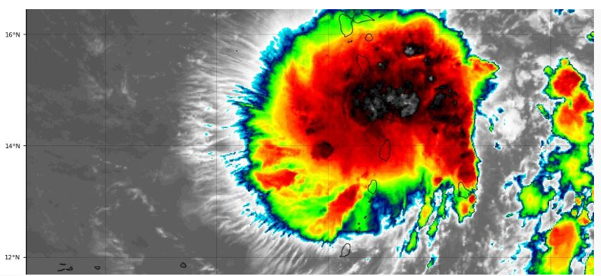
Latest IR satellite image of Tropical Storm Dorian with a little dry air intrusion on its southeast side; courtesy NOAA
Overview
Tropical Storm Dorian has been relatively stable over the past 24 hours in terms of intensity and it moved directly over the center of St. Lucia earlier today. The track of the tropical storm will likely bring it right near the area between Puerto Rico and Hispaniola over the next day or two and it will encounter some dry air along the way. After an encounter with these two Caribbean islands, whatever remains of TS Dorian will likely push to the Bahamas later this week and then ultimately to Florida during the upcoming holiday weekend.
General agreement between numerous computer forecast models in the track of Tropical Storm Dorian which could “thread the needle” between Puerto Rico and Hispaniola before an encounter with the Bahamas later this week and Florida this weekend. Courtesy NOAA, UCAR
Discussion
TS Dorian has max sustained winds at 50 mph as of 11AM and is continuing to move on a WNW track at 13 mph. Despite a disruption in its mid-level circulation with the passage over St. Lucia, the overall circulation envelope remains intact as it pushes over the eastern Caribbean. Dry air that has pushed westward from the African continent will plague TS Dorian in the near-term, but the upper-level flow pattern and wind shear conditions should remain favorable for strengthening. In addition, sea surface temperatures in the Caribbean are rather favorable for strengthening with many spots warmer-than-normal for this time of year as high as 29°C. The longer-term intensity outlook for this system will largely depend on its interaction with Puerto Rico and Hispaniola. A movement directly over the rugged terrain of Hispaniola where there are mountains greater than 10,000 feet could weaken the storm considerably. However, a track between Puerto Rico and Hispaniola would likely result in somewhat less weakening and this “threading the needle” scenario is on the table.
Tropical Storm Dorian (circled) will battle with drier air over the Caribbean Sea during the next couple of days. This drier pushed westward from the continent of Africa in recent days and is usually an inhibiting factor for tropical storm intensification. Courtesy University of Wisconsin/CIMSS
Once TS Dorian gets passed these two Caribbean islands, it’ll head towards the Bahamas and could strengthen some over the warm waters of the southwestern Atlantic later this week. Ultimately, most signs point to TS Dorian moving right to the Florida Peninsula which could very well be impacted during the upcoming holiday weekend.
00Z Euro (hi-res) forecast map for Friday evening, August 30th with a rather impressive-looking tropical system near the Bahamas. Once TS Dorian bypasses the Caribbean islands of Puerto Rico and Hispaniola, it could strengthen before its arrival in the Bahamas and Florida. Map courtesy WSI, Inc, Michael Ventrice (twitter), ECMWF
Elsewhere on the tropical scene, there is another tropical wave drifting over the western Atlantic, but “TD 6” has seen a separation of its low-level circulation center with the main band of clouds, showers and thunderstorms and this will limit intensification prospects in coming days. The moisture field of TD 6 will get intertwined with a frontal system as it pushes slowly to the northeast over the next couple of days before ultimately getting pushed farther out-to-sea with the arrival from the west of an upper-level trough.
The low-level circulation center of tropical depression 6 (circled) has separated from the main band of clouds, showers and thunderstorms and this will reduce its chances of intensification. Courtesy NOAA
Stay tuned…intensity questions still remain.
Meteorologist Paul Dorian
Perspecta, Inc.
perspectaweather.com
Video discussion:


