
11:55 AM (Friday) | *Another slow moving tropical system to impact the Bahamas and Florida*
Paul Dorian
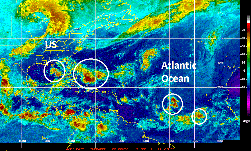
Multiple systems to monitor in the Atlantic Basin in this the climatological peak time period of the tropical season; courtesy NOAA, CIMSS University of Wisconsin
Overview
Here we go again…another slow moving tropical system will impact the Bahamas and Florida over the next couple of days in what is a very active looking tropical scene. There are numerous systems of interest right now across the Atlantic Basin which is not too unusual given the time of year which is the climatological peak period of the tropical season. In addition to the system over the Bahamas, there is a batch of showers and thunderstorms over the eastern Gulf of Mexico that may organize in coming days and two other disturbances in the eastern Atlantic. Furthermore, multiple systems over the continent of Africa – the breeding grounds for the Atlantic Basin – assure us that it’ll remain active as we progress through the month of September.

General agreement by numerous computer forecast models on the future track of the tropical system now over the Bahamas; courtesy NOAA, tropicaltidbits.com
Bahamas/Florida
A tropical system now over the Bahamas has a chance to intensify into tropical storm status over the next couple of days (would be named Humberto) despite the fact that it is in an area of moderate wind shear. In fact, it is not out of the question that we will be dealing with Hurricane Humberto by later in the weekend or early next week. In much the way Hurricane Dorian slowed down to a halt over the Bahamas, this system is now nearly stationary as the overall wind field in the atmosphere is rather weak. There is likely to be a general push to the northwest over the next couple of days and this system could reach near the east coast of Florida by early next week. At that point in time, there will be a mid-latitude trough moving eastward and this should result in a turn to the north and then to the northeast and away from the SE US coastline.

High pressure ridging across southeastern Canada is always a red flag this time of year in terms of the potential for tropical activity near the US east coast; courtesy NOAA, tropicaltidbits.com
By the middle of next week once this system pushes away from the SE US coastline, there will be strong high pressure building into the Great Lakes region and south-central Canada. There is an outside chance that the tropical system could become influenced later next week by the building high pressure ridging which could cause it to take a turn back towards the coastline – something that will need to be monitored next week.

Multiple systems to monitor over Africa as they are moving to the west towards the tropical Atlantic; courtesy NOAA, CIMSS University of Wisconsin
Other activity in the Atlantic Basin
Elsewhere, the front running system in the eastern Atlantic has a good chance of moving into the eastern Caribbean Sea in about five days or so and it also has a decent chance of intensification. As such, it’ll have to be closely monitored and there is yet another system that trails now just off the west coast of Africa. Indeed, latest satellite imagery shows a few more waves of low pressure over the continent of Africa that are pushing along westward with the tropical trade winds. In the eastern Gulf of Mexico, there is a batch of showers and thunderstorms that could better organize over the next few days as it heads westward towards the Texas Gulf coastal region.

Image of a full (harvest) moon; courtesy AP
An interesting tidbit
One final note of interest, this happens to be Friday the 13th with a full moon and that only happens about 1% of the time with the last one taking place in the year 2000. [Technically speaking, the full moon will actually take place shortly after midnight on the 14th in some parts of the US depending on your time zone]. This particular “Friday the 13th full moon” is even rarer as it is occurring near apogee, the farthest point in the moon's orbit. This hasn't happened since 1832 and won't happen again for more than 500 years. A full moon at apogee is sometimes referred to as a micro or mini moon and it will appear about 14% smaller and 30% dimmer than when it is at its closest point to Earth, which is known as perigee.
Meteorologist Paul Dorian
Perspecta, Inc.
perspectaweather.com
Video discussion: