11:20 AM (Friday ) | *Remnants of “Eta” now back out over the warm waters of the Caribbean Sea…poses a threat to Cuba and southern Florida by early next week*
Paul Dorian
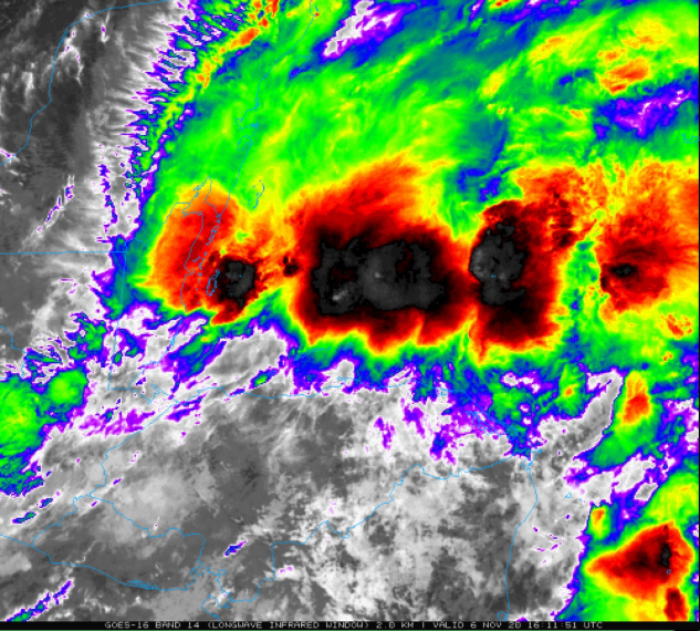
Tropical Depression Eta has now pushed back out over the warm waters of the Caribbean Sea and it generating an elongated band of convection (i.e., thunderstorms). Image courtesy College of DuPage, NOAA
Overview
Hurricane Eta made landfall earlier this week as a category 4 (“major”) storm on the northeastern coastline of Nicaragua in Central America. After landfall, Eta brought torrential rainfall and widespread flooding to both Nicaragua and Honduras as it traveled slowly to the west. While over land, the system weakened into tropical depression status, but it has now emerged back out over the warm waters of the western Caribbean Sea just to the east of Belize. As such, it is likely to intensify as it treks northeastward this weekend and will likely return to at least tropical storm status by the time it reaches the island of Cuba for a second landfall. After that, Eta is likely head to the Florida Straits and could impact the Keys of southern Florida early next week – perhaps even as a hurricane.
Warmer-than-normal water currently exists in the western part of the Caribbean Sea as well as in the eastern Gulf of Mexico. Map courtesy tropicaltidbits.com, NOAA
Details
At 10AM, Tropical Depression Eta was situated just to the east of the Central America country of Belize and is now over the warmer-than-normal waters of the far western Caribbean Sea. Satellite imagery shows an organized band of convection in the storm’s northeastern quadrant with an elongated circulation. With the development of upper-level divergence and a movement over the warm waters of the Caribbean during the next 48 hours or so, Eta is likely to strengthen into tropical storm status by the time it reaches Cuba later in the weekend. The most recent landfalling named storm in Cuba during the month of November is Paloma (2008) which made landfall as a category 2 hurricane.
Many computer forecast models depict a movement of Eta into Cuba and then southern Florida by the latter part of the weekend and early part of next week. Map courtesy weathermodels.com, NOAA
After a second landfall in Cuba likely on Sunday, the remains of Eta should push into the Florida Straits and there could be an impact on southern Florida and the Florida Keys by early Monday – perhaps even as a hurricane. It is unclear on its movement during the early part of next week as it could meander around for a couple of days or push up along the west coast of Florida.
Meteorologist Paul Dorian
Perspecta, Inc.
perspectaweather.com
Follow us on Facebook, Twitter, YouTube
Video discussion:


