
12:45 PM | *Massive weekend snowstorm from Colorado/Wyoming to parts of the central Plains with extreme amounts possible Denver-to-Cheyenne and in the higher elevations to the west*
Paul Dorian
Overview
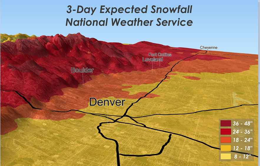
It is not too unusual for big snowstorms this time of year across the Rocky Mountain States, but this weekend event has the potential to be an historic blockbuster. The threat for significant snow during this long duration event will stretch from Colorado and Wyoming to the western sections of Nebraska and South Dakota. While these numbers are still subject to change, the potential exists for 1-3 feet of snow in the Denver-to-Cheyenne corridor and even more than that in the higher elevations to the west.

The weekend storm will be a long duration event in places like Denver, Colorado and Cheyenne, Wyoming with snowfall extending from Friday night into Sunday night. Map courtesy NOAA, tropicaltidbits.com
Details
A powerful wave of energy in the upper part of atmosphere will reach the Rocky Mountain States early this weekend and it will tend to slow down and deepen allowing for an extended period of moderate-to-heavy snowfall in Colorado/Wyoming and to western sections of the central Plains. Given the expected positioning of the upper-level trough, upslope flow is likely to intensify dramatically this weekend with strong easterly winds and warm air advection will also contribute to copious amounts of total precipitation amounts in the mountains and foothills – perhaps on the order of 1.50-3.00 inches of liquid equivalent for the immediate Denver metro region.

There is the potential that the weekend snowstorm in the Rocky Mountain States will rival some of the all-time great storms in places like Cheyenne, Wyoming.
With a very cold air mass in place, precipitation amounts on the order of an inch and a half to three inches could very well result to as much as 1-3 feet of snow in the Denver, Colorado metro region and in the corridor to the north to Cheyenne, Wyoming - and even higher amounts of up to 4 or 5 feet in the foothills and mountains to the west. The potential of significant snow this weekend extends from Colorado/Wyoming to western sections of South Dakota and Nebraska. In addition to the snow, winds will become quite a factor by later Saturday in the Rocky Mountains with gusts to 50 mph possible continuing right through the day on Sunday. Yet another strong trough of low pressure could move across this same part of the country early next week potentially resulting in additional significant snowfall.

These two plots show the total snow accumulation amounts for the upcoming long duration event in Denver, Colorado (left) and Cheyenne, Wyoming (right) based on the mean of all ensemble members of the 12Z GFS (Wed.) model run. The thick, black line (i.e., the mean value) depicts 30+ inches of snow for both places in what could be an absolute blockbuster storm in the Denver-to-Cheyenne corridor. Plots courtesy NOAA (GEFS)
In Denver, there have been only three times in recorded history with more than 2 feet of snow and this kind of extreme amount is a certainly on the table from what will be a long duration event. In Cheyenne, it has already been a notable winter season as they have already experienced their coldest day ever for so late in the season with -7 degrees (F) recorded as a maximum temperature on Valentine’s Day. The heaviest snowstorm on record in Cheyenne is 25.6” which took place in another long duration event from November 19-21, 1979 - the upcoming weekend storm could approach these kind of extreme amounts. In Fort Collins, Colorado, a storm with 24” of snow has only happened twice in over 130 years of records, and 30” was measured only once (32.2” on March 18-19, 2003).
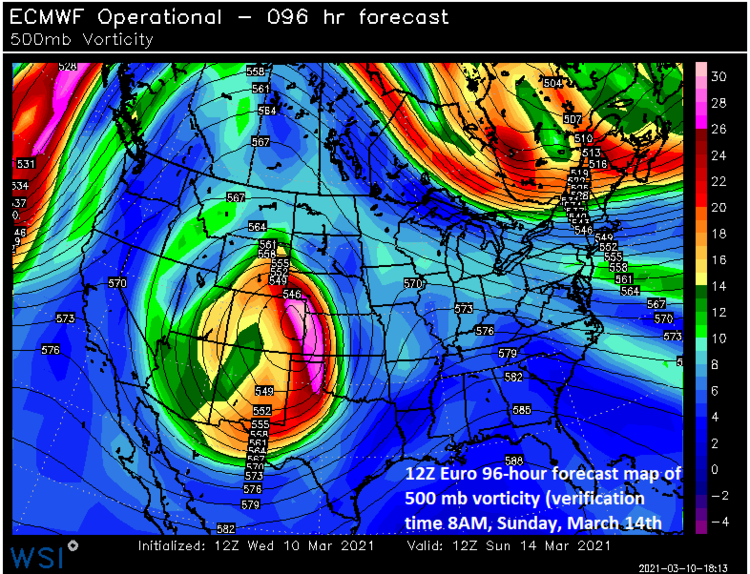
A powerful system in the upper atmosphere will contribute to a major weekend snow event in Colorado and Wyoming and extending to western sections of the central Plains. Map courtesy WSI, Inc., ECMWF
This long duration weekend event is certainly shaping up to be one of the all-time great snowstorms for northeastern/north-central Colorado and southeastern Wyoming.
Meteorologist Paul Dorian
Perspecta, Inc.
perspectaweather.com