
1:45 PM | **Upper-level pattern change to bring extreme heat to the western states and a refreshing air mass into the Northeast US...tropical activity soon to begin over the Gulf of Mexico**
Paul Dorian

A strong upper-level low is likely to drop southeastward next week into the Great Lakes, Mid-Atlantic and Northeast US at the same time strong high pressure ridging builds across the western states. Map courtesy NOAA, tropicaltidbits.com
Overview
Strong high pressure in the upper part of the atmosphere will build into the western US early next week at the same time a vigorous upper-level low drops southeastward from Canada into the Northeast US. As a result, some extreme heat - and potentially record-breaking heat - is likely to develop in the western US for the early and middle parts of next week at the same time refreshing cooler-than-normal air drops into the Great Lakes, Mid-Atlantic and Northeast US. Elsewhere, there are strong signs for some tropical activity later next week or weekend over the Gulf of Mexico which could be the first significant system of the 2021 Atlantic Basin season.

A refreshingly cool air mass is likely to drop southeastward next week into the Great Lakes, Mid-Atlantic and Northeast US at the same time extreme heat builds across the western states. Map courtesy NOAA, tropicaltidbits.com
Details
Death Valley, CA could reach 125 degrees by the middle of next week for afternoon highs and Phoenix, AZ could top out near 120 degrees. In fact, the extreme heat that will unfold next week is likely to be rather widespread across the western US from California-to-New Mexico and northward to near the US/Canadian border. This wave of extreme heat will be brought about by a shift to the west of an upper-level high pressure system that will intensify as it builds into the western states. The southwestern US will continue to see little to no rain as this heat builds next week – continuing to exacerbate drought conditions in that part of the country.
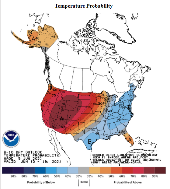
Odds are quite high next week for warmer-than-normal weather across the western US and cooler-than-normal in the eastern states. Map courtesy NOAA
Meanwhile, across the country in the northeastern quadrant, a vigorous upper-level low will drop southeastward from Canada by the middle of next week. This system will likely be centered over the interior portion of the Northeast US and the air mass associated with it is likely to be quite a bit below-normal for this time of year across the Great Lakes, Mid-Atlantic and Northeast US.

There are strong signs of tropical activity over the Gulf of Mexico next week or weekend which could be the first important system of the 2021 Atlantic Basin tropical season. This forecast map from the 12Z GFS features a tropical system over the western Gulf of Mexico during the third week of June. Map courtesy NOAA, tropicaltidbits.com
There are signs that this pattern featuring a split in the nation from extreme heat out west to much more comfortable conditions in the east may last into the end of next week. By that time, there may be another feature to watch and that is the strong possibility of a tropical system over the Gulf of Mexico which could be the first significant system of the 2021 Atlantic Basin tropical season.
Meteorologist Paul Dorian
Peraton
peratonweather.com
Follow us on Facebook, Twitter, YouTube
Video discussion: