7:15 AM | *The “Storm of the Century” March 12-14, 1993*
Paul Dorian
Composite satellite image of the 1993 superstorm (source: NOAA)
Overview
The winter of 1992-1993 was not bad at all in the Mid-Atlantic region in terms of cold and snow, but one storm at the end of the season will put that particular winter in the history books forever. One of the most intense storms ever observed in the eastern US took place from March 12-14, 1993 and it will be forever known as the “Storm of the Century”. This intense storm generated tremendous snowfall totals from Alabama through Maine, high winds all along the east coast, extreme coastal flooding along the Florida west coast and incredibly low barometric pressures across the Southeast and Mid-Atlantic regions. The aftermath of the “Storm of the Century” was unseasonably cold and broke records in many spots for the middle of March. To this day, the storm also known as the “Superstorm of 1993” ranks among the deadliest and most costly weather events in US history.
Mechanics behind the blizzard with three separate jet streaks playing a role (credit: AccuWeather, Inc., State College, Pa.)
Details
Low pressure developed on the day of March 12th along a stationary frontal system over the Texas Gulf coast. Meanwhile, temperatures over much of the eastern US began to drop as Arctic high pressure built into the Midwest and Great Plains. Upper-level conditions were very favorable for intensification of the low pressure system as multiple jet streaks (polar, Pacific, sub-tropical) were about to phase together at just the right time for explosive strengthening. By the early hours of March 13th, central pressure of the low pressure system dropped to about 990 millibars and it was just the beginning of a dramatic descent. The low pressure headed towards northwest Florida with a significant storm surge and a squall line developed along the cold front. Numerous tornadoes were reported across Florida and substantial severe thunderstorm damage was reported all the way south to Cuba.
By the time the low pressure system crossed southern Georgia, cold air was beginning to wrap into the system. Widespread heavy snow and blizzard conditions developed from Alabama and Georgia on March 13th and into the Carolinas and Virginia. In fact, all-time snowfall records were set from Birmingham and Chattanooga to Asheville, then spreading north into the central Appalachians.
By late in the day on March 13th, the central pressure of the low pressure system was lower than that observed with any winter storm in the interior Southeast US. In fact, all-time low pressure records were set in Columbia, Charlotte and Greensboro, even beating out pressures observed just a few years earlier during powerful Hurricane Hugo (Sept., 1989).
Surface map on the morning (12Z) of March 13th, 1993 (Source: NOAA)
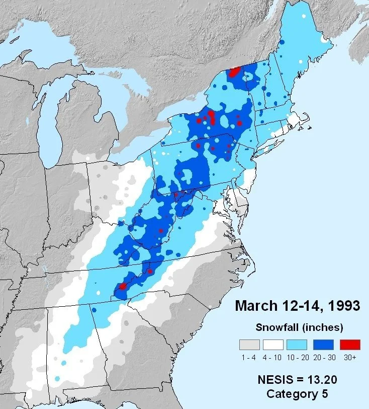
By the nighttime hours of the 13th, the low pressure system headed to a position over the Delmarva Peninsula. Heavy snow and blizzard conditions spread through interior sections of the Mid-Atlantic and Northeast US and fierce winds blew snow around into massive drifts. The big cities of DC, Philly, and NYC had travel issues and schools shut down for days as more than a foot of snow accumulated in parts of those metro regions before a changeover to sleet and rain near the end of the storm. Pressure dropped to 28.43 inches in Philadelphia during the storm and to 28.54 inches at Reagan National Airport (DCA). Hurricane-force winds pounded the coastal sections of the Mid-Atlantic and Northeast US. Some of the highest snowfall totals occurred at interior locations including 60 inches on Mount LeConte, TN, 42.9 inches in Syracuse, N.Y., 30.9 inches in Beckley, W.Va., and 25.3 inches in Pittsburgh, Pa.
Snowfall totals from the 1993 superstorm (Source: NOAA; Kocin and Uccellini)
Miscellaneous facts about the “Storm of the Century”
(credit Jesse Ferrell, AccuWeather):
- 65-Foot waves were reported off of Nova Scotia, Canada
- 28.38 inches pressure was measured at White Plains, NY (Cat 3 Hurricane Strength)
- Havana, Cuba was blacked out during the storm; $1 billion damage in the country
- 60,000 lightning strikes were measured during the storm
- Hurricane-force winds caused hurricane-like damage in Florida, along with 11 tornadoes
- For the first time, every major airport on the East Coast was closed at one time or another by the storm.
- 300 Deaths were blamed on the storm in the U.S.
- 130 Million People (Half the nation's population) affected by the storm
- A 12-foot storm surge attacked Florida's west coast
- Hundreds of roofs collapsed due to snow up and down the East Coast
- New York City set a new record low (6) for March on the day after the storm
- The volume of rain that fell was equivalent to 40 days of Mississippi River flow at New Orleans
- Over 10 million customers lost electrical power during the storm
- At least 18 homes fell into the sea on Long Island due to the pounding surf.
- Extremely cold weather followed including a record low of 2 degrees in Birmingham, AL
Meteorologist Paul Dorian
Arcfield
arcfieldweather.com
Follow us on Facebook, Twitter, YouTube


