
10:45 AM | *The Earth’s upper atmosphere is an interesting place these days…to be impacted by a “cannibal” coronal mass ejection in the near-term and there is an on-going stratospheric warming event*
Paul Dorian
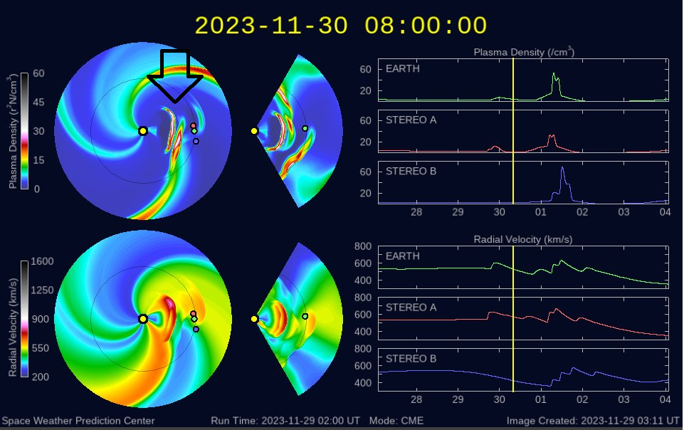
WSA-Enlil is a large-scale, physics-based prediction model of the heliosphere, used by NOAA’s Space Weather Forecast Office to provide 1-4 day advance warning of solar wind structures and Earth-directed coronal mass ejections (CMEs) that cause geomagnetic storms. Solar disturbances have long been known to disrupt communications, wreak havoc with geomagnetic systems, and to pose dangers for satellite operations. The Sun is represented as a yellow dot, the Earth by a green dot, and the two STEREO spacecraft by the red and blue dots. The top row represents the WSA-Enlil predicted solar wind density and the bottom row the predicted solar wind velocity. The debris locations associated with an initial CME (slower) and a follow-up CME (faster) is indicated by the arrow. Courtesy NOAA
Overview
The Earth’s upper atmosphere is an interesting place these days and will be impacted in the near-term by a so-called “cannibal” coronal mass ejection (CME). In addition, there is an on-going stratospheric warming event that can have an impact on winter weather conditions across parts of the nation later in the month of December and possibly well into January as well. The incoming CME can result in some communication problems on Friday, December 1st and it certainly can produce northern lights potentially visible all the way down into the middle latitudes. The unfolding stratospheric warming event can increase the chances for cold air outbreaks to make their way this winter season from the higher latitudes to the middle latitudes.
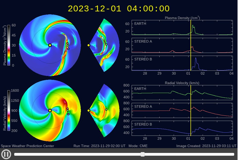
The “cannibal” CME is predicted by this model to hit Earth’s upper atmosphere on Friday, December 1st. Courtesy NOAA
“Cannibal” Coronal Mass Ejection and a potential strong geomagnetic storm
The sun has been quite active recently with numerous sunspot regions as it climbs towards a solar maximum phase for the current cycle, 25, and this max may take place as early as late 2024. As activity has increased, coronal mass ejections have become more commonplace and multiple such events have taken place in just the past several days. In this particular setup, particles from an initial coronal mass ejection are being “chased” by debris from a follow-up CME. Indeed, space weather prediction models suggest the second CME will catch up with the first and the combination of the two may contain intense, tangled magnetic fields that can spark auroras when they reach Earth.
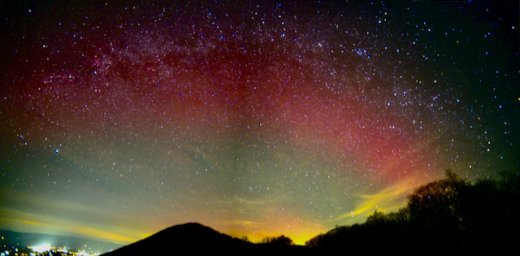
Greg Redfern photographed this deep-red arc example from the Shenandoah National Park in Virginia on November 5th, 2023…the last G3-class geomagnetic storm. Courtesy spaceweather.com
If this “cannibal” CME indeed reaches Earth on Friday, December 1st as predicted, it could result in geomagnetic storm levels of G3 (strong) that can disrupt communication, wreak havoc with geomagnetic systems, and even pose dangers for satellite operations. According to spaceweather.com, the last G3-class storm took place on November 5th and sparked not only bright auroras, but also deep-red “glowing” zones known as Stable Auroral Red (SAR) arcs. In the G3-class event earlier this month, these deep-red arcs were seen as far south as Texas.
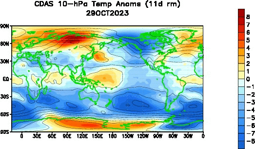
The temperature pattern across the globe in the lower stratosphere (10 millibars) during the past 30-days features significant warming (shown in orange) in the Northern Hemisphere polar region (60 degrees (N)- 90 degrees (N)). Courtesy NOAA
An unfolding Stratospheric Warming Event
During the winter months in the lower polar stratosphere, temperatures are typically lower than minus 70° Celsius (purple areas in temperature plot). The cold temperatures are combined with strong westerly winds that form the southern boundary of the stratospheric polar vortex. The polar vortex plays a major role in determining how much Arctic air spills southward toward the mid-latitudes. This dominant structure is sometimes disrupted in some winters or even reversed. Under these circumstances, the temperatures in the lower stratosphere can rise by more than 50°K in just a few days. This sets off a reversal in the west-to-east winds and the collapse of the polar vortex or a shifting of it from its usual position over the North Pole to another part of the polar region. In response to the stratospheric warming at the high latitudes, the troposphere in turn cools down dramatically and this cold air displacement is then transported from the tropospheric high latitudes to the tropospheric middle latitudes.

A “conventional-looking” polar vortex currently exists right near the North Pole as indicated here with this 10 millibar temperature analysis. Courtesy NOAA
The current temperature pattern at 10 millibars shows a “conventional-looking” polar vortex very close to the north pole (small circle at center of plots), but the forecast for a week from now features significantly warming in the polar region and a displacement of the vortex. The impact of a stratospheric warming event in the middle latitudes can take several weeks so this particular scenario could increase chances for cold air outbreaks in the central and eastern US during the second half of December and perhaps even well into the month of January.

The temperature forecast for one week from now features warming aloft near the north pole and a slight displacement of the polar vortex. This stratospheric warming event could set off a chain-reaction in the atmosphere that can increase the chance for cold air outbreaks in the central and eastern US later in December and perhaps well into January as well. Courtesy NOAA
We’ll continue to monitor the progress of the changing temperature pattern aloft in coming weeks. For a detailed video discussion on the stratospheric warming phenomenon, visit our “Meteorology 101” page and scroll down the page for the “Stratospheric Warming” video..
Meteorologist Paul Dorian
Arcfield
arcfieldweather.com
Follow us on Facebook, Twitter, YouTube
Video discussion: