
9:30 AM (Friday) | ****Hilary peaks overnight as a category 4 "major" hurricane...significant impacts coming to SoCal and other parts of SW US despite upcoming weakening phase****
Paul Dorian

Hilary is a “major” hurricane on Friday morning with a well-defined eye and it has begun a turn to much more of a northerly direction rather than the prior west-to-northwest movement. The expected track of Hilary will bring it into southern California by late Sunday night likely with “tropical storm” status as it’ll undergo weakening from this point to landfall. Images courtesy NOAA/NESDIS/STAR (GOES-West)
Overview
Hilary likely reached its peak in strength during the overnight hours as a category 4 “major” hurricane and it is about to enter into a weakening phase as it it crosses over colder waters of the eastern Pacific Ocean. Despite the upcoming weakening phase, the remnants of Hilary will have a significant impact on California, Nevada and western Arizona from this weekend into early next week. The widespread moisture field associated with Hilary is then likely to continue pushing northward ultimately reaching the states of Idaho, Oregon and Washington.

A “high” risk of excessive rainfall has been issued by NOAA’s Weather Prediction Center for portions of southern California as the expected path of Hilary will likely result in a movement of the remnants directly overhead. Map courtesy NOAA/WPC
Discussion
Hilary has reached category 4 “major” hurricane status and features maximum sustained winds of 145 mph on Friday morning which is about twice the intensity just 24 hours ago. The latest satellite imagery loop features a well-defined eye and the movement appears to be much more of a northerly direction as compared with west-to-northwest in prior observations. The turn to the north has been expected as the result of high pressure ridging that is pushing away to the east and an upper-level low that is approaching California from the west. By mid-day Sunday, the center of the remnants of Hilary will likely be skirting the west coast of the Baja peninsula with a “tropical storm” classification. By later Sunday, the center of the remnants of Hilary will likely push over southern California - likely classified as a tropical storm - and its expected northward movement will result in an eventual track right over the state of Nevada.

A compilation of GEFS ensemble members predict Hilary will head towards the west coast of northern Baja by later this weekend. Map courtesy NOAA
Upcoming Impacts
Despite the upcoming weakening phase of Hilary, this tropical cyclone will bring significant impacts to much of the Southwest US from later this weekend into early next week with the greatest concern in southern California where a direct “remnants-hit” is increasingly likely. Copious amounts of tropical moisture will flow northward into the SW US and excessive rainfall amounts of 6-12 inches are on the table from the northern Baja California peninsula to southern California. This kind of rainfall would produce substantial flash flooding conditions; especially, in the inland, higher elevation locations of southern California where upsloping winds will enhance precipitation amounts. One example of a place that will likely receive excessive (and unusual) rainfall amounts is Death Valley National Park where 3 or 4 inches are possible. While excessive rainfall and flooding are the biggest risks to the SW US from Hilary, damaging (easterly) wind gusts are possible given the likely northward movement through the southern part of the Golden State.

The track of Hurricane Kathleen in September 1976 may be the closest historical comparison to the expected path of Hurricane Hilary. Map courtesy Wikipedia, Weather Bell Analytics (Joe Bastardi, Twitter)
Historical Comparisons
In the overnight hours, Hurricane Hilary intensified into category 4 (“major”) status. In a very similar position during September of 1997 (and also during a strong El Nino episode), Hurricane Linda strengthened all the way to category 5 status. After that, Hurricane Linda turned well to the northwest of the Baja California peninsula and did not significantly impact the state of California. Hurricane Hilary probably failed to reach category 5 status last night as it interacted with some dry air in the mid-levels of the atmosphere.
In terms of landfalling hurricanes in California, there haven’t been any as far back as we have records with perhaps the closest coming in 1858 when the “San Diego” storm missed by only a few miles. In terms of landfalling tropical storms in California, according to some reports (and I haven’t been able to confirm this), there have been three tropical systems in the past century - “Long Beach” in 1939, Kathleen in 1976, and Nora in 1997 - that actually reached California with a “tropical storm” designation - Hurricane Hilary has a chance to become the 4th.
Perhaps the one storm of those three that may be the closest analogy to Hurricane Hilary in terms of its track is Hurricane Kathleen which impacted California in September 1976. The possible track of Hilary to a position first over the northern Baja peninsula and then over the southern part of California closely resembles the track that Hurricane Kathleen actually followed in September 1976. One final note on Hurricane Kathleen, it took place just a few months prior to one of the coldest winters ever for the eastern US…the winter of 1976-1977. In fact, the month of January in 1977 turned out to be one of the coldest months ever recorded in the continental US.
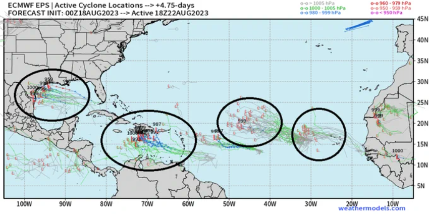
While attention on the tropics is currently focused on the eastern Pacific, the Atlantic Basin is coming to life in a big way and several systems will have to be closely monitored in coming days. Map courtesy ECMWF, weathermodels.com (Dr. Ryan Maue, Twitter)
A Final Note
One final word with respect to the overall tropical scene, the Atlantic Ocean has (finally) become quite active with as many as four systems to monitor in coming days. In fact, a Gulf of Mexico system could indeed evolve into a tropical storm by sometime later next week with a potential impact in Texas…stay tuned on all of this activity.
Meteorologist Paul Dorian
Arcfield
arcfieldweather.com
Follow us on Facebook, Twitter, YouTube
Video discussion from Thursday AM: