
10:00 AM | **Active pattern for Pacific NW…a very wet Florida…an unseasonably cool Mid-Atlantic region**
Paul Dorian
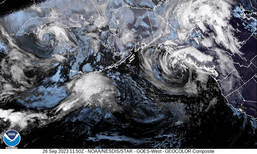
An active jet stream over the northern Pacific Ocean will bring multiple systems into the Pacific NW in coming days. Images courtesy NOAA/GOES-West
Overview
There is no tropical activity of any immediate concern across the nation, but the overall weather pattern is having a pretty big impact on three different sections of the US. An active jet stream across the northern Pacific is bringing multiple storms to the Pacific NW that will generate lots of rain for lower elevations and some early season snowfall for the higher elevation locations. A stalled-out frontal boundary zone will combine with an abundance of low-level moisture to bring significant rainfall amounts to Florida in coming days. Meanwhile, in the Mid-Atlantic region, it’s the same old song with damp, breezy and unusually cool conditions that began during the weekend with the approach and passage of Tropical Storm Ophelia.

Its that time of year where snow can begin to accumulate across the higher elevations of the northwestern US and indeed, a stormy pattern over the next ten days will bring some decent snowfall across SW Canada, Washington and Montana. Map courtesy NOAA, tropicaltidbits.com
Pacific NW
A powerhouse storm system off the west coast of Canada has already produced some rainfall in the Pacific NW and more will fall into the day on Wednesday. In some of the higher elevation locations of southwestern Canada and the Pacific NW, it will be cold enough for some early season snowfall. Looking upstream, another system is pushing along in the jet stream now nearing the Aleutian Islands of Alaska and it is likely to impact this same part of the nation later in the week. Some of that moisture will then works its way into the interior western US with additional rain in low-lying areas and more snowfall in the mountains (e.g., Montana, Wyoming). The rain that is coming to the Pacific NW is actually quite welcome as much of this area featured very dry conditions during the summer season. In addition to the rain, the weather in the Pacific NW has been cooler-than-normal in recent days and that pattern will continue for the next few days.

Two hot spots for precipitation across the nation during the next ten days will be the Pacific NW and the state of Florida. Multiple storms will impact the Pacific NW in coming days (and snow in higher elevations) and a stalled-out frontal boundary zone will be the culprit to very wet weather across the Sunshine State. Map courtesy NOAA, tropicaltidbits.com
Florida
It is not unusual for the state of Florida to receive soaking rainfall this time of year, but that is often the result of organized tropical storm systems. In this particular weather pattern, there is no real tropical storm or hurricane threat for Florida in the next several days; however, soaking rain will indeed fall as the result of other factors including a stalled- out frontal boundary zone and lots of low-level moisture. An upper-level ridge of high pressure over the Bahamas is producing southwesterly flow aloft and a couple of waves aloft will push northeastward across Florida during the next few days. At the surface, a southeasterly flow on the southwest flank of the Bahamas ridge will pump in very high precipitable water amounts for the latter part of September opening the door for soaking rainfall amounts of at least a few inches through the week.
This overall pattern will become more unstable in nature as well over the next few days raising the possibility of severe thunderstorm activity each of the remaining days of the work week. The best chance for severe thunderstorms over the Florida Peninsula will be during the more typical afternoon and evening hours when daytime heating reaches its highest levels. By the weekend, an upper-level ridge of high pressure will intensify over the central US and, in turn, surface high pressure will amplify over the eastern states. The end result in Florida will be somewhat similar to the next few days i.e., quite a moist flow of air and, in this case, a freshening onshore flow likely continuing the chance for rain through the weekend.

Temperatures have been well below normal in the Mid-Atlantic region thanks to a persistent onshore flow of air (NE winds). This unseasonably cool weather will hang on in this part of the nation through the remainder of the work week. Map courtesy NOAA, tropicaltidbits.com
Mid-Atlantic region
The high temperature this afternoon in both Philly and DC will not be all that far from the 60 degree mark which is well below the normal on September 26th of the mid or upper 70’s. The unseasonably cool weather began late last week and continued through the weekend with the approach and passage of Tropical Storm Ophelia which helped to set up an onshore flow of air that continues to this day. The onshore flow continues now as the result of strong high pressure that is located over the southeastern part of Canada. This high will be combining with an approaching upper-level trough of low pressure to keep the cool weather in place through the remainder of the week and there will continue to be breezy and damp conditions at times. Ultimately, the high pressure system over southeastern Canada will push down into the Mid-Atlantic region and bring about drier weather conditions and this improvement in the weather pattern should take place over the upcoming weekend.
Meteorologist Paul Dorian
Arcfield
arcfieldweather.com
Follow us on Facebook, Twitter, YouTube
Video discussion: