7:15 AM | *America’s Deadliest Natural Disaster…the Galveston Hurricane of 1900...the efforts of meteorologist Isaac Cline*
Paul Dorian
Surface weather analysis on September 8, 1900 featuring the Galveston hurricane just before landfall. Map courtesy US Weather Bureau (now the National Weather Service)
Overview
At the end of the 19th century, America was beaming with confidence and feeling bigger and stronger than ever before. The city of Galveston, Texas was booming with a population of 37,000 residents on the east end of Galveston Island which runs about thirty miles in length and anywhere from one and a half to three miles in width. Its position on the harbor of Galveston Bay along the Gulf of Mexico made it the center of trade and the biggest city in Texas in the year 1900. A quarter of a century earlier, a nearby town was destroyed by a powerful hurricane and this object lesson was heeded by many Galveston residents and talks of a seawall to protect the city were quite prevalent. However, no seawall was built and sand dunes along the shore were actually cut down to fill low areas in the city, removing what little barrier there was to the Gulf of Mexico. This proved to be a fatal mistake for the city of Galveston in what nobody could foresee happening to this magical place that seemed destined to become the New York of the Gulf of Mexico.
Background
In August of 1900, there was a prolonged heat wave that gripped much of the nation and killed dozens of people in some of the biggest cities like New York and Chicago. Other manifestations of the abnormally warm climate that year included the melting of Bering Glacier in the state of Alaska. Galveston itself experienced some tremendous rainfall intensity that summer and, by late August, the local residents couldn’t help but to have an uneasy feeling as they knew the heart of the hurricane season had arrived and there was not nearly the weather observation network that we have today with satellites and radar. In fact, ship reports were the only reliable tool for observing hurricanes at sea, but these were of somewhat limited warning value as they had no way of telegraphing weather observations ashore.
The storm begins
The first formal observation for a developing new eastern Atlantic Ocean storm occurred on August 27th when a ship recorded an area of “unsettled weather” about 1000 miles east of the Windward Islands. This storm is believed to have begun as a “Cape Verde-type” hurricane – a tropical wave moving off the western coast of Africa. By September 1st, the US Weather Bureau observers were reporting on a “storm of moderate intensity” southeast of Cuba. The storm made landfall on southwest Cuba, but some of the reports that surfaced from Cuba were simply not believed as there was a distrust of Cuban weather forecasters. By September 5th, the system emerged into the Florida Straits as a tropical storm or weak hurricane.
A difficult prediction and the heroic efforts of Meteorologist Issac Cline
By the time the storm reached a position just to the northwest of Key West, Florida on September 6th, many US Weather Bureau forecasters were convinced it would track to the northeast. However, once the system moved out over the open waters of the Gulf of Mexico, it began to strengthen and head westward – on a collision course with the Texas coast. The Galveston Weather Station Chief, Issac Cline, was becoming increasingly suspicious of the overall weather situation as he observed what was unfolding. This was in an era in which there were no satellites to help meteorologists track tropical systems nor any computer forecast models to rely on. By the afternoon of the 7th, he noticed the large swells on the Gulf of Mexico coming towards Galveston Island from the southeast and the clouds at all altitudes began moving in from the northeast – both observations consistent with a hurricane approaching from the east. It was at this time that Cline and the Galveston Weather Bureau office ordered its double square flags to be flown indicating a hurricane warning was in effect.
Isaac M. Cline is most famous for his actions as Meteorologist-in-Charge of Galveston, Texas, during the Great Hurricane of 1900. The story of the hurricane and Cline’s efforts were captured in a book entitled “Isaac’s Storm” (Larson, E. (1999), New York, N.Y.: Crown Publishing Group)
Devastation hits on September 8th
Early on the morning of Saturday, September 8th, Cline harnessed his horse to a cart, drove to the beach, and warned every one of the impending storm advising them to get to higher ground immediately. At the time, the highest point in the city was only 8.7 feet above sea level (source CBS19, Tyler, Texas). By early afternoon on September 8th, the Bureau office was recording hurricane-force winds. In the early part of the night of September 8th - a terrifying night that reshaped the Gulf of Mexico forever - the wind direction shifted to the east, and then to the southeast as the eye began to pass over the island just to the west of the city. The hurricane brought winds that evening estimated to be near 145 mph at landfall making it a Category 4 on today’s rating scale – stronger than Hurricane Katrina (2005) - at the time of its landfall. It also brought a storm surge of over 15 feet that inundated most of Galveston Island and the city of Galveston. During the storm, Cline and his brother Joseph continued to send updated reports to headquarters until the last of the telegraph lines went down.
The deadliest natural disaster ever in the US
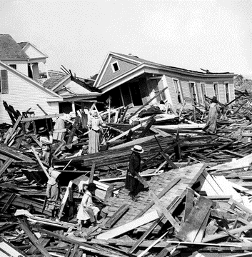
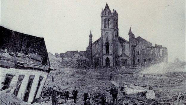
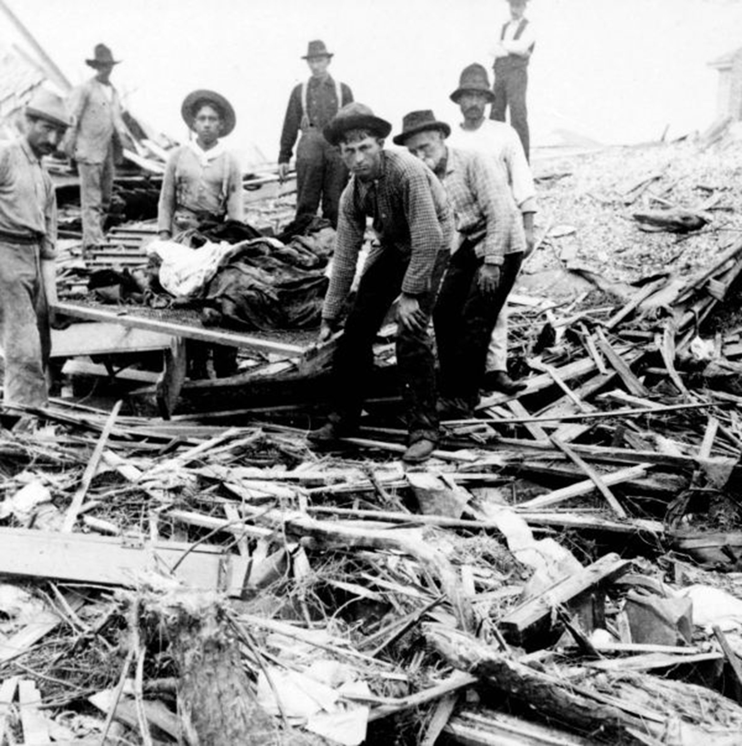
By the next morning, skies had cleared and a 20 mph breeze greeted the Galveston survivors, there were 3600 homes destroyed leaving about a quarter of the population homeless, and it was quite obvious that there was a tremendous loss of life. One of the structures destroyed was Cline’s own house, where his wife, three daughters, brother, and about 50 neighbors took refuge from the storm. Cline and his brother managed to save his three daughters, but his wife was among the thousands who died that night. The Galveston Hurricane of 1900 is estimated to have killed as many as 12,000 individuals, but the number most often cited in official reports is 8000 – the true number will never be known. Despite the horrendous loss of life, many people were saved by Cline's actions that day.
The Galveston Hurricane of 1900 is the deadliest natural disaster to ever strike the US. By contrast, the second deadliest storm to strike the US, the 1928 Okeechobee hurricane, caused more than 2500 deaths and the deadliest storm of recent times, Hurricane Katrina of 2005, claimed the lives of approximately 1800 people. The storm continued on its trek producing lots of heavy rain and strong winds along the way, first tracking into Oklahoma, then the Great Lakes, and ultimately to near Halifax, Nova Scotia. As far away as New York City there were winds estimated as high as 65 mph - some four days after the devastation occurred in Galveston.
This map shows the approximate path and intensity level of the 1900 Galveston hurricane. Map courtesy NOAA
The rebuilding of Galveston
Galveston never regained its former status as a major commercial center as development shifted north to Houston, which was enjoying the benefits of an oil boom. The citizens of Galveston decided to rebuild and in a remarkable feat of civil engineering raised the grade of the entire city and built a seawall to help protect it from future storms.
First built following the 1900 storm, the seawall at Galveston now spans more than ten miles providing protection to the heart of the city. Photograph courtesy NOAA
Dredged sand was used to raise the city of Galveston by as much as 17 feet above its previous elevation. A 17-foot seawall was built beginning in 1902 and initially spanned nearly 50 blocks providing protection for heart of the city. In 1915, a storm similar in strength and track to the 1900 hurricane struck Galveston. This storm brought a 12-foot storm surge which tested the new seawall. Although nearly 50 people died on Galveston Island during the storm in 1915 with the majority in unprotected portions, this was a great reduction from the thousands who died in 1900 during the worst natural disaster America has ever faced. Additional sections have been added to the seawall over the years and it now spans more than 10 miles; however, some two-thirds of the island remains in harm’s way.
The post-hurricane life of Isaac Cline
In August of 1901, Cline and his children moved to New Orleans, where he would assume the duties of forecaster-in-charge of the recently created Gulf District. His forecasting responsibility was extended beyond Texas and Oklahoma, to include the states of Louisiana, Arkansas, Mississippi, Alabama, and northwestern Florida. Now situated in coastal Louisiana, along the banks of the Mississippi River, he was in a prime location to further his research into tropical cyclones and to demonstrate the efficacy of his flood-forecasting capabilities.
Between 1900 and 1924, Cline meticulously charted meteorological data observed during 16 cyclones affecting the Gulf and Atlantic coasts. He was personally involved with 10 of those storms and his work dramatically advanced tropical cyclone forecasting methodology. Prior to his work, cyclone studies were based primarily on broad synoptic charts with little support from observation data. In contrast, Cline's method determined the storm's probable path by observing minimum air pressure and wind shifts recorded at stations ahead of and to the sides of the cyclone. He then plotted the track on a map indicating hourly positions, wind and cloud directions, wind speeds, and precipitation.
Cline published his research on tropical storms in a book called Tropical Cyclones in 1926. In a review published four years later in the Quarterly Journal of the Royal Meteorological Society, it was said that: "This book constitutes a notable advance in the collection and representation of precise data with regard to tropical cyclones of the North Atlantic Ocean, observed at coastal and inland stations of the American continent." Widely recognized as a landmark achievement in weather research, his book soon became a "must read" text for aspiring meteorologists throughout the world.
Meteorologist Paul Dorian
Arcfield
arcfieldweather.com
Follow us on Facebook, Twitter, YouTube


