
11:30 AM - ****Hurricane Milton has intensified rapidly and is on the doorstep of “category 5” designation...headed for a possible late Wednesday landfall right near Tampa Bay****
Paul Dorian

Hurricane Milton is on the verge of category 5 classification and is in an environment of highly favorable conditions over the southwestern Gulf of Mexico. Images courtesy NOAA/GOES-East
Overview
Hurricane Milton has intensified rapidly during the past 24 hours over the southwestern Gulf of Mexico and is now classified as a strong category 4 “major” hurricane...just on the doorstep of a category 5 designation. Given the very favorable environmental conditions, Hurricane Milton is likely to reach category 5 status later today as it heads slowly to the east-southeast. Hurricane Milton is expected to turn to the northeast later tomorrow which would bring the system to Florida’s Gulf coast region by later Wednesday...likely right near or just to the north of Tampa Bay. There can be some weakening of Hurricane Milton in the hours before landfall due to some “late in the game” dry air intrusion; however, landfall as a “major” would still be quite possible during the PM hours on Wednesday. With a possible landfall near or just to the north of Tampa Bay, storm surge in the bay region would be significant...perhaps as high 8-12 feet. After landfall, Hurricane Milton is likely to cross over the Florida Peninsula as a hurricane, and then exit off the east coast on Thursday to the open waters of the southwestern Atlantic.
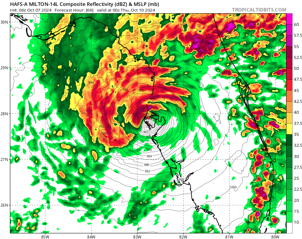
NOAA’s hurricane model known as the “HAFS” places landfall near Tampa Bay late Wednesday which would likely result in a significant storm surge in the bay region of as much as 12 feet. Map courtesy NOAA, tropicaltidbits.com
Details
Hurricane Milton has intensified rapidly during the past 24 hours and is now classified as a “major” category 4 storm with the likelihood of attaining category 5 status in the very near future. Hurricane Milton is currently traveling quite slowly over the very warm waters of the southwestern Gulf of Mexico with a forward speed of 9 mph in and east-to-southeast direction. This current track will put the storm near or just to the north of the Yucatan Peninsula by later today and early tonight and then Hurricane Milton should turn to a more northeasterly direction on Tuesday putting in on track to reach the west coast of Florida by later Wednesday.
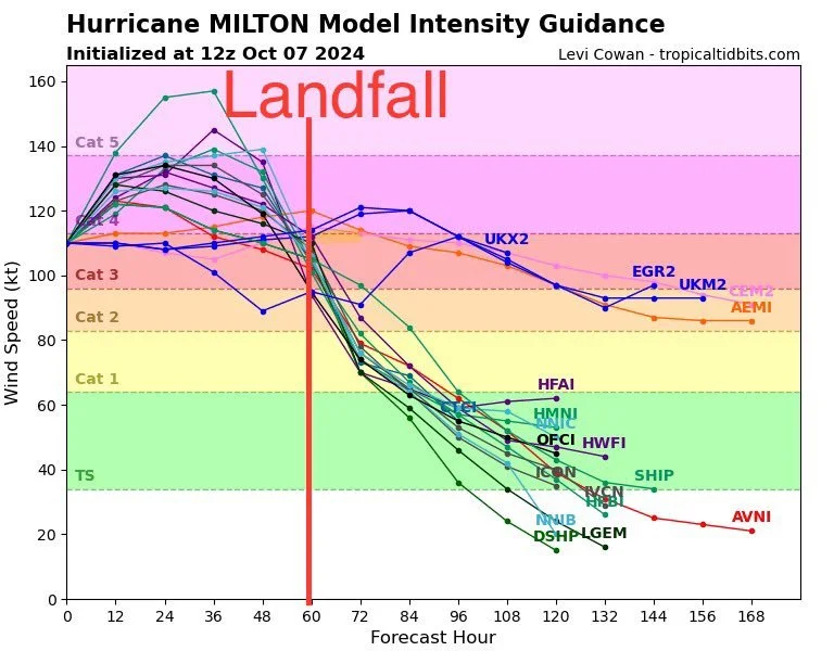
Hurricane Milton is likely to reach category 5 status in the very near term and it can weaken some just before landfall due to some “last minute” dry air intrusion. Map courtesy tropicaltidbits.com
Current indications are that Hurricane Milton may make landfall near or just to the north of Tampa Bay later Wednesday. This would put much of the Tampa Bay region on the right side of the landfalling hurricane which tends to feature the most significant storm surge due to the “additive” effects of the storms forward speed and the powerful surface winds that blow counterclockwise around low pressure systems and, in this case, would push water into Tampa Bay from the Gulf. As a result, the possibility exists for a significant storm surge during this storm of as much as 12 feet in and around the Tampa Bay region.
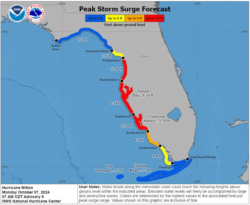
The peak storm surge typically takes place near and to the right of the landfalling hurricane location which potentially places Tampa Bay in the main threat zone of storm surge as high as 12 feet. Map courtesy NOAA/NHC
There is the chance that Hurricane Milton has its highest intensity of category 5 status out over the open waters of the Gulf of Mexico where environmental conditions are very favorable (warm water, low wind shear, high moisture). However, in the hours just before landfall, there are some indications that some dry air may entrain into the system which could cause some weakening of the hurricane early Wednesday. Even with some “last minute” weakening of Hurricane Milton, it can still make landfall as a “major” and then cross over the state as a hurricane producing significant storm surge along the coast and hurricane-force winds and flooding rainfall throughout much of the Florida Peninsula.
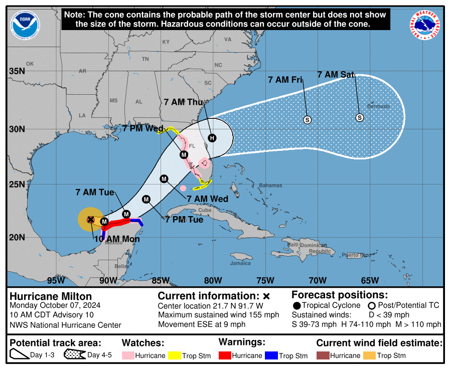
The latest storm track by NOAA’s National Hurricane Center places landfall along Florida’s west-central Gulf coast later Wednesday. Map courtesy NOAA/NHC
Meteorologist Paul Dorian
Arcfield
arcfieldweather.com
Follow us on Facebook, Twitter, YouTube
Video discussion: