11:45 AM (Wednesday) - ****Major Hurricane Milton to make landfall near Tampa Bay around midnight...some weakening today****
Paul Dorian

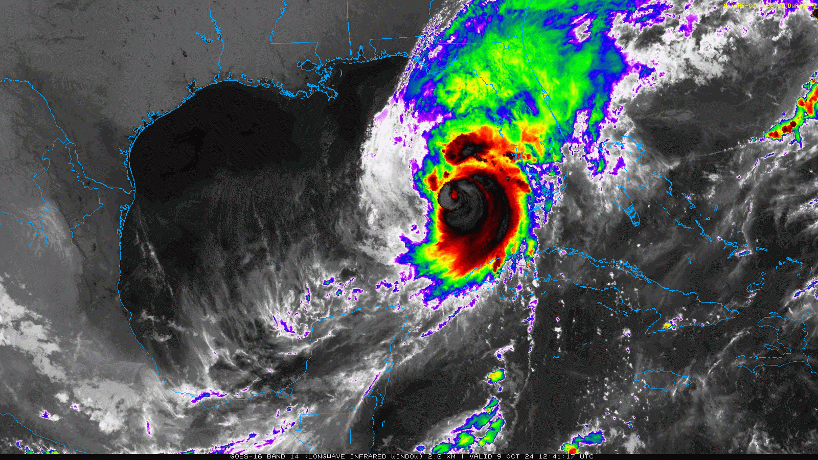
Major Hurricane Milton is closing in on the west-central Gulf coastal region of Florida with a likely landfall shortly after midnight somewhere near Tampa Bay. Images courtesy NOAA, College of DuPage
Overview
Hurricane Milton is a high-end category 4 storm system as of mid-morning as it closes in on the west-central Gulf coast of Florida. Some weakening is quite likely today as Hurricane Milton encounters increased vertical wind shear over the eastern Gulf of Mexico and some dry air intrusion on its western side. However, Hurricane Milton should make landfall later tonight somewhere near Tampa Bay as a “major” hurricane with a significant storm surge expected as high as 10-15 feet in some areas. After landfall, Milton will cross the state as a hurricane and then emerge later tomorrow out over the open waters of the southwestern Atlantic Ocean.

Peak storm surge associated with Major Hurricane Milton is likely to be as high as 10-15 feet later tonight/early Thursday just to the south of the landfalling location. Map courtesy NOAA/NHC
Details
Hurricane Milton was classified as a category 5 storm (157 mph winds or greater) earlier today; however, it has weakened a tad in recent hours now being designated as a very strong category 4 system (130 mph - 156 mph winds) with maximum sustained winds of 155 mph. I believe there will be some additional weakening today of Hurricane Milton as it encounters increased vertical wind shear over the eastern part of the Gulf of Mexico and there can be some dry air intrusion on its western side. The latest satellite imagery loop suggests there is some shearing already impacting the storm as it has a “lopsided” look to it rather than yesterday’s “fully symmetrical” appearance.

Milton will cross over the central part of Florida later tonight and early Thursday still classified as a hurricane bringing hurricane-force winds and intense rainfall amounts of a foot or more along its path. Map courtesy NOAA/NHC
Hurricane Milton has accelerated in recent hours now moving along at 16 mph in a northeasterly direction which should make for a landfall around midnight in the Tampa Bay region. With the expected slight weakening expected today, the hurricane may end up being a “low-end category 4” or “high-end category 3” storm at the time of landfall later tonight in the west-central Gulf coastal region of Florida. As Hurricane Milton undergoes some slight weakening today, its overall size may actually become larger and its wind field should broaden as opposed to being concentrated in a smaller area. This broadening of the wind field, in turn, raises the risk of damaging winds over a wider area of the Florida Peninsula from later today through early Thursday. Overall conditions across Florida will deteriorate this afternoon with heavy rain bands and increasingly strong winds. In addition, as is typical with tropical systems the threat of tornadoes will increase on the south and east side of the storm’s track (i.e., in its warm sector) and this may result in numerous tornadoes later today and tonight across much of the southern half of Florida.

This is the latest official storm track by NOAA’s National Hurricane Center bringing Milton into west-central Florida as a major hurricane. Map courtesy NOAA/NHC
After landfall, Milton will cross over the central part of the state and likely remain classified as a hurricane to the east coast of Florida. This path would bring hurricane-force winds and intense rainfall to the interior and eastern sections of central Florida in the overnight hours and early Thursday morning (e.g., from Orlando to Titusville). Once Milton exits Florida’s east coast later tomorrow, it is likely to drop to tropical storm status over the western Atlantic Ocean and then it may have some impact on the island of Bermuda this weekend.
In terms of storm surge, the peak generally occurs just to the right of the landfalling location where there are “additive” effects of the storms forward motion and the powerful surface winds that blow counterclockwise around low pressure systems. If the landfall is just to the north of Tampa Bay, then the peak storm surge could be in the immediate Bay region and as high as 10-15 feet as low-level winds would tend to push water into the bay from the Gulf. If the landfall takes place just to the south of Tampa, then the peak storm surge of as much as 10-15 feet would likely take places down the coast a bit from Tampa perhaps in the zone from Anna Marie Island to Boca Grande. The trend during the past few hours favors the idea of a landfalling hurricane directly over Tampa Bay or just to the south of there, but all sections of the west-central Gulf coast are likely to experience significant storm surge from Anclote River to the north and Bonita Beach to the south.
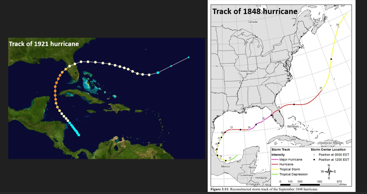
The tracks are shown here of two hurricanes in the past that had direct hits on the Tampa Bay region of Florida’s Gulf coast; October 1921 (left), September 1848 (right).
From a historical point of view, Hurricane Milton is in rare company when it comes to storm tracks that take a system from the southwestern Gulf of Mexico to Florida’s west-central coast...not unprecedented, but it doesn’t happen too often. As far as direct hits go in Tampa with “major” hurricanes, those occurrences are rather infrequent as well. One such storm took place in 1921 with a track that took it from the Caribbean Sea to the zone between western Cuba and Yucatan Peninsula, and then a turn to the northeast brought it right into Tampa. Another landfalling “major” hurricane that had a direct hit on Tampa took place back in 1848 with a track that mimics Milton...taking it from the southwestern Gulf of Mexico to the eastern Gulf.
Meteorologist Paul Dorian
Arcfield
arcfieldweather.com
Follow us on Facebook, Twitter, YouTube
Video discussion: