
1:45 PM | **Cold California storm system to produce tremendous snowfall amounts in the Sierra Nevada Mountains**
Paul Dorian
How would you like to have this forecast for your area? (Forecast courtesy NOAA/National Weather Service)
Overview
A very cold low pressure system that is currently rotating around the Gulf of Alaska is already impacting the region from northern California to Washington and it has the rest of California in its sights. This cold storm system promises to be long-lasting and it is very likely to produce tremendous snowfall amounts in the higher elevations of the Sierra Nevada Mountains with as much as 11 or 12 feet on the table. The air mass sliding into the western US will become increasingly colder-than-normal over the next few days and this will allow snow to fall at relatively low elevations in the state of California.

A very cold storm system is now rotating around in the Gulf of Alaska (see “twirl” in clouds) and it will make a move to the south in coming days and impact California this weekend. Images courtesy NOAA/GOES-West
Details
Strong, cold surface low pressure is currently rotating around the Gulf of Alaska and it will begin a push to the south during the next 24 hours or so. This storm is supported aloft by an upper-level trough that will deepen over the next couple of days as it digs southward through the eastern Pacific Ocean. The upper-level low will become anchored near Vancouver Island by later tomorrow night and Saturday, and a strong short-wave will rotate through its southern side into the western US during the weekend.

A powerful jet streak aloft will contribute to the instability across California, Washington and Oregon during the next few days as a cold storm system pushes towards Vancouver Island. This forecast map features a strong jet streak (indicated by purple) over the northern half of California by early Saturday morning. Map courtesy NOAA, tropicaltidbits.com
While there have been numerous storm systems in recent weeks that have impacted the state of California with rain and snow, this one is liable to beat all of those with respect to snowfall amounts in the Sierra Nevada Mountains. This upcoming cold storm system may very well produce snowfall amounts on the order of 11 or 12 feet by the latter part of the weekend in the higher elevations of eastern California. The Tahoe Basin is likely to see 4-8 feet of snowfall at elevations of 7000 feet and higher, and 2-4 feet of snow on towns in the Lake Tahoe area. Winds will also become a big factor with ridge-top gusts of over 100 mph possible in the Sierra Mountains and 50 mph possible this weekend in low elevation locations such as the Sacramento Valley. In addition, accumulating snow is very likely this weekend across the interior western US extending from Idaho/Nevada to the Colorado Rockies.
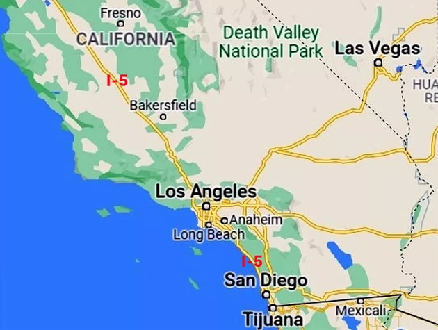
This will be an unusually cold storm system affecting California this weekend and snow levels may drop to 4000 feet or so which could result in some problems along the higher portions of I-5. map courtesy U.S. Fish and Wildlife Service, Google Maps
As precipitation pushes farther to the south and east across California during the next couple of days, the air mass will become increasingly colder-than-normal. As a result, this cold storm system will end up producing snow at unusually low elevations of 4000 feet or so which could cause some problems on, for example, the higher portions of Interstate 5.

Snowfall will be quite intense in coming days across the Sierra Nevada Mountains with as much as 11 or 12 feet possible from this upcoming cold storm system. In addition. accumulating snow is likely across the interior western US from Idaho/Nevada to the Colorado Rockies. Map courtesy NOAA, tropicaltidbits.com
In terms of rainfall, this storm is already producing some significant amounts in the Pacific Northwest with flood watches currently active in places such as Seattle, Washington, and a couple of inches of rain is likely this weekend in, for example, the LA metro region. However, the biggest story coming out of California in coming days with this cold strong storm system is not likely to be the rain, but rather the massive snowfall that is expected to pile up in the Sierras.
Meteorologist Paul Dorian
Arcfield
arcfieldweather.com
Follow us on Facebook, Twitter, YouTube
Video discussion: