
*Sea surface temperatures drop markedly during past year across the all-important tropical regions*
Paul Dorian

Water temperatures have dropped off markedly during the past year or so in tropical regions around the world. Sea surface temperature anomalies of a year ago (left plot) have in most tropical regions transitioned from above-normal (shown in orange) to nearly neutral conditions of today (right plot). Maps courtesy Canadian Met Centre
Overview
While global sea surface temperatures continue to run at above-normal levels, there has been a rather dramatic cooling trend across tropical regions all around the world. During the past year or so, water temperatures in the Indian Ocean have dropped to nearly neutral levels around India and well above-normal levels immediately east of Africa have moderated to only slightly above-normal conditions. In the central part of the tropical Pacific Ocean, relatively neutral water temperatures have replaced the El Nino conditions of a year ago when water temperatures were as much as two degrees higher than normal. Perhaps the most dramatic change in water temperatures has taken place in the tropical Atlantic Ocean where much warmer-than-normal conditions of a year ago are virtually normal as we approach the end of April and there is even a pocket of colder-than-normal water just off Africa’s west coast. The tropics are a critically important part of the world with respect to the total energy budget and cooling trends can certainly have an inhibiting impact on the upcoming tropical season.
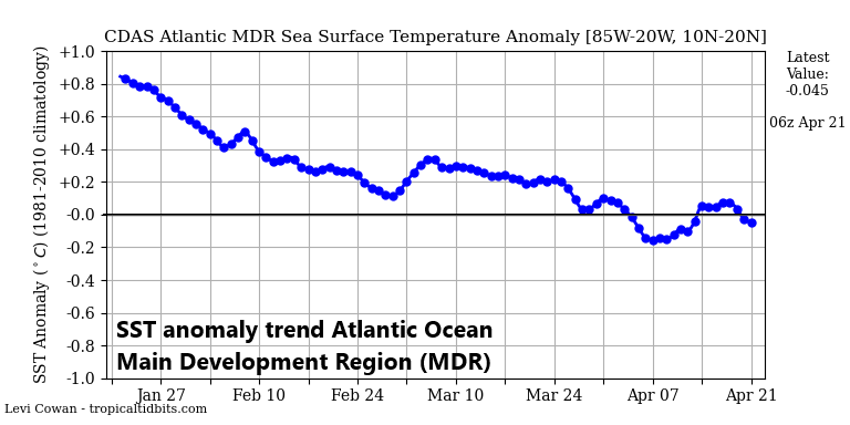
The “Main Development Region (MDR)” of the Atlantic Ocean has been in a long-term downward trend that began early in 2025. Water temperatures are now right near the neutral line as we approach the summer tropical season on the Atlantic Basin. Map courtesy NOAA, tropicaltidbits.com
Details
Water temperatures across the world’s tropical regions have generally trended downward during the past year or so and, in some cases, there has been quite a dramatic turnaround. The theories on the tropical cool down range from fluctuations due to natural oceanic cycles to changes in underwater volcanic activity (credit Meteorologist Joe Bastardi of Weather Bell Analytics on this theory) and this can include the possibility of waning effects from the 2022 Hunga-Tonga eruption which was an extremely large volcanic event in the South Pacific.

The last 3 or 4 weeks has featured a sharp cool down in water temperatures of the eastern equatorial Pacific Ocean (upper, right) in the area just off the west coast of South America. Map courtesy NOAA, tropicaltidbits.com
Whatever the cause, water temperatures have trended down in the tropical part of the Indian Ocean from well above-normal levels just to the east of Africa to only slightly above-normal and nearly neutral conditions exist in the nearby region surrounding India. Meanwhile, the central part of the tropical Pacific Ocean has cooled off quite a bit during the past 12 months or so with an El Nino event a year ago transitioning to neutral conditions today as we close in on the end of April. Meanwhile, the tropical Atlantic Ocean has changed rather dramatically during the past year or so with a widespread area of much warmer-than-normal water now nearly neutral.

While this map just shows a short-term (7-day) trend in seas surface temperature anomalies, it has been a rather sharp cool down in the eastern Pacific Ocean region (boxed area) during the past week. Map courtesy NOAA, tropicaltidbits.com
Water temperature trends in the tropics are especially important this time of year as we approach the tropical season in the Indian, Pacific, and Atlantic Oceans. Warm ocean water is crucial for tropical storm and hurricane activity because it provides the heat and moisture necessary for storms to form and intensify. For a tropical cyclone to develop, the ocean surface temperatures need to be at least 80 degrees (F) according to many studies, and the warmer the water, the more moisture is in the air.

Warm ocean water of at least 80 degrees (F) is generally agreed upon as the threshold for the formation of tropical activity. (Credit weather.gov for the graphical representation of processes involved with tropical storm formation)
Cooling trends in water temperatures as we approach the tropical season can certainly have suppressing effects on storm formation; especially, if in “breeding grounds” regions such as is indeed the case currently across the “Main Development Region” of the Atlantic Ocean where temperatures have dropped since early this year. In fact, a pocket of colder-than-normal water has formed just off the west coast of Africa which can inhibit the formation and/or intensification of tropical wave activity that typically pushes westward from Africa into the tropical Atlantic. These water temperature trends were important factors in our “2025 Tropical Season Outlook” issued earlier this month and will be closely monitored in coming weeks.
Meteorologist Paul Dorian
Arcfield
arcfieldweather.com