
Tuesday PM - *Atlantic Basin tropical season has been quiet so far, but a ramp up in activity is coming in August*
Paul Dorian
Tropical activity has picked up dramatically in recent days across both the eastern and western Pacific Ocean. One of the catalysts for this uptick in activity is the positioning of the MJO which currently favorable in the Pacific. As the MJO slides steadily eastward in coming days, look for activity to pick up across the Atlantic Basin. Map courtesy University of Wisconsin/CIMSS, NOAA
Overview
The Atlantic Basin tropical season typically reaches a peak around the middle of September and the preceding month of August usually features a steady ramp up in overall activity. Indeed, adhering to the climatological theme, it appears that tropical activity is about to pick up in the Atlantic Basin after we flip the calendar from July to August, and it could feature multiple systems. A teleconnection index known as the Madden-Julian Oscillation or MJO is providing support to this idea and suggests the time period from around August 5th to the 20th could be one to watch.
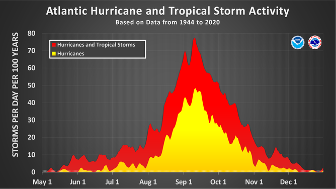
The Atlantic Basin tropical season reaches a climatological peak in mid-September and tends to ramp up steadily during the preceding month of August. Plot courtesy NOAA
Details
Tropical activity has been below-normal so far this season in the Atlantic Basin as well as across the Pacific and Indian Oceans. There is plenty of time left, however, for this to change significantly and activity has already picked up noticeably across both the eastern and western sections of the Pacific Ocean – aided in large part by the current positioning of the Madden-Julian Oscillation or MJO.

So far this tropical season has been below-normal in the North Atlantic with respect to the Accumulated Cyclone Energy (right column) which is calculated using both the magnitude and longevity of tropical systems. In addition, activity has been below-normal across the Pacific and Indian Oceans to this point; however, there is plenty of time left in the season for things to change significantly. Table courtesy Colorado State University, NOAA
The MJO is an oceanic-atmospheric phenomenon that is tracked closely by meteorologists as it can have important effects on weather patterns across the globe. Unlike El Nino or La Nina which are stationary features in the equatorial Pacific Ocean, the MJO is an eastward moving disturbance of clouds, rainfall, winds and pressures that traverse the planet in the tropics and returns to its initial starting point in 30 to 60 days, on average. The MJO was first discovered in the early 1970s by Dr. Roland Madden and Dr. Paul Julian when they were studying tropical wind and pressure patterns.

The Madden-Julian Oscillation or MJO is expected to push into Phases 8, 1 and 2 in August in this is typically correlated with an uptick in activity across the Atlantic Basin. Map courtesy ECMWF, NOAA
The MJO consists of two parts or phases with one being the enhanced rainfall (convective) phase and the other being the suppressed rainfall phase. The location of the convective phases is often grouped into geographically based stages that are numbered 1-8 by scientists. The MJO creates favorable conditions for tropical cyclone development, and it is likely playing an important role in the dramatic uptick in activity across the Pacific Ocean which includes Hurricane Iona...the strongest July hurricane since 2020.
The last thirty days have generally featured unfavorable conditions for tropical activity to develop in the Atlantic Basin with respect to the positioning of the MJO. However, as it progresses steadily eastward along the tropics during the next several days, much more favorable conditions are likely to develop in the Atlantic Basin; especially, during the period from around August 5th to the 20th. And given the evolution of the overall weather pattern to more favorable (i.e., Phases 8, 1 and 2), it is possible that we’ll have to deal with multiple systems in the Atlantic Basin during the month of August...stay tuned.
Meteorologist Paul Dorian
Arcfield
arcfieldweather.com
Follow us on Facebook, Twitter, YouTube
Video discussion: