
*El Nino conditions to return to the tropical Pacific Ocean by the summer (tropical) season with implications in the Atlantic Basin*
Paul Dorian
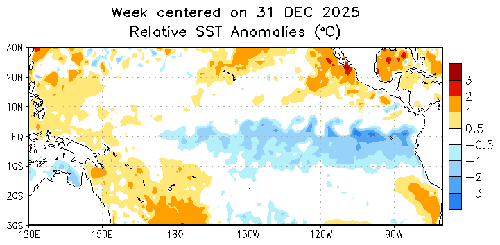
This loop of sea surface temperature anomalies runs from 31 December 2025 to 18 March 2026, and it reflects La Nina conditions across the equatorial part of the Pacific Ocean with colder-than-normal water (shown in blue). However, the last few frames indicate that the colder-than-normal region tends to be shrinking in size with warmer-than-normal water encircling it (shown in orange). This is part of the process that will likely result in ENSO-neutral conditions during the next several weeks and then El Nino (warmer-than-normal) conditions by the early summer across the tropical Pacific Ocean. Map courtesy NOAA/CPC [Note - “Nino 3.4” region is 5 °N-5°S, 120°W-170°W.]
Overview
Below-normal sea surface temperatures continue this month across much of the equatorial part of the Pacific Ocean, but there are signs that this La Nina episode is about to enter “ENSO-neutral” status, and then likely flip to El Nino conditions by the early part of the summer (tropical) season. A change from La Nina to El Nino across the equatorial Pacific Ocean can have big implications for the upcoming Atlantic Basin tropical season. Indeed, warmer-than-normal water associated with an El Nino episode in the tropical Pacific is often an inhibiting factor for tropical activity in the Atlantic Basin. This is due to increased wind shear in the atmosphere; especially over the Caribbean Sea during typical El Nino summer seasons, and this inhibits the development and intensification of tropical storms. A second potential inhibiting factor for tropical activity in the Atlantic Basin this summer is the chance that colder-than-normal water will develop across much of the tropical Atlantic Ocean according to some longer-range forecast models.
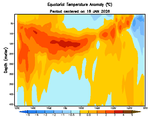
Sub-surface water temperature anomalies (°C) down to a depth of 450 meters are shown here from the equatorial part of the Pacific Ocean in the period from 18 January 2025 to 19 March 2026. Warmer-than-normal water (shown in orange) is now lurking just beneath the surface (top) across much of the tropical Pacific and the cold water (shown in blue) at and just below the surface level has tended to shrink in extent in recent days. Map courtesy NOAA/CPC, International Research Institute [Note – “Nino 3.4” region is 120°W-170°W.]
Details
A transition from La Nina to “ENSO-neutral” is likely during the next several weeks and odds are increasing for a full-blown El Nino episode by the time we get to the summer season in the Northern Hemisphere which coincides with the first part of the Atlantic Basin tropical season. La Nina conditions with colder-than-normal water have generally dominated the scene in the equatorial Pacific Ocean throughout the past couple of years, and 5 of the 6 winters this decade have featured similar colder-than-normal sea surface temperatures. The one exception to the dominance of La Nina this decade has been the emergence of a weak-to-moderate El Nino that took place during the second half of 2023 and first half of 2024.
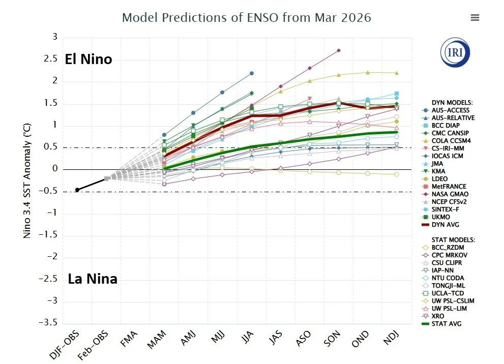
Forecasts of sea surface temperature (SST) anomalies are shown for the “Nino 3.4” region (5 °N-5°S, 120°W-170°W) of the tropical Pacific by a compilation of computer forecast models with general agreement on El Nino conditions after brief period of “ENSO-neutral”. The computer models encompass two types – statistical and dynamic – with the average of each highlighted (red for dynamic, green for statistical). Courtesy NOAA, ECMWF, Canadian Met Centre, International Research Institute
While sea surface temperatures are currently at below-normal levels in the tropical Pacific Ocean, there are changes lurking just beneath the surface…literally. Water temperatures from the surface level to about 50 meters beneath remain below-normal as we approach the latter part of March; however, the colder-than-normal region appears to be shrinking in recent weeks as warmer-than-normal water has gradually risen closer to the top and, in some areas, the sub-surface water is considerably warmer-than-normal. The increasing odds of El Nino are supported by the large amount of heat observed in the sub-surface ocean.
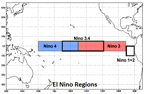
The El Nino region of the Pacific Ocean is sub-divided by meteorologists into sub-sections as outlined on this map with “Nino 3.4” region (5 °N-5°S, 120°W-170°W, boxed region in middle) in the central part of the equatorial Pacific Ocean and “Nino 1+2” (boxed region at right) positioned near the west coast of South America.
In addition to oceanic and atmospheric observational reasons to support the idea of a change in the near-term with respect to La Nina, there are modeling reasons as well. Numerous computer forecast models predict a transition from La Nina to “ENSO-neutral” during the spring season and then to El Nino conditions by the summer. Specifically, temperatures in the “El Nino 3.4” region (central part of the equatorial Pacific Ocean) are predicted to rise in most computer forecast models from the current nearly half a degree below-normal levels to near neutral during the spring season, and then to 1.0°C or so higher-than-normal by the early part of the summer.
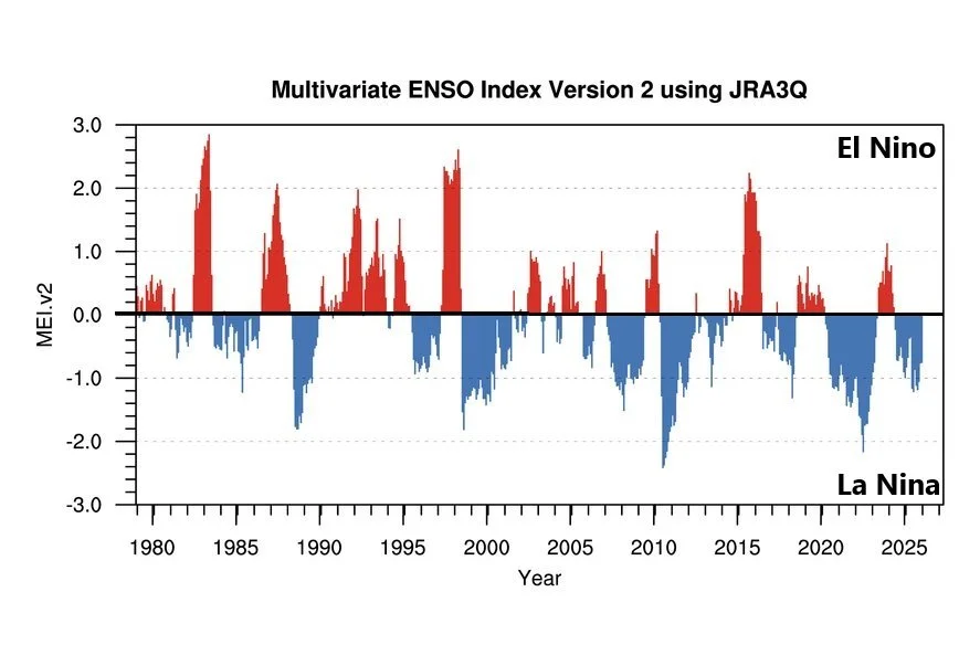
The Multivariate ENSO Index (MEI), which combines both oceanic and atmospheric variables, facilitates in a single index assessment of ENSO. It provides real-time indications of ENSO intensity, and through historical analysis, it provides a context for meaningful comparative study of evolving conditions (El Nino in red, La Nina in blue). The strongest El Nino events since 1980 took place during 1982-1983, 1997-1998 and 2015-2016. Plot courtesy NOAA/PSL
In terms of impact on weather, La Nina conditions during the just-ending 2025-2026 winter season likely has been a contributing factor to drier-than-normal weather across many parts of the western US (e.g., Arizona, Colorado) and a change to El Nino raises hope that precipitation will increase in these areas many of which are designated as drought-stricken. The picture is somewhat mixed across the nation with regards to impact by El Nino on summer weather; however, if it were to last into the winter of 2026-2027 then the impacts could become more significant. Indeed, El Nino winters often result in higher precipitation amounts across the western and southern states with an increased influence by moisture-laden Pacific Ocean storm systems...too early to say if El Nino will last into next winter season.
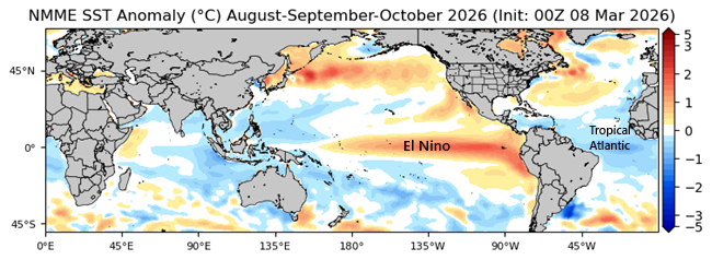
This forecast map of sea surface temperature anomalies for the 3-month period of August-September-October features warmer-than-normal conditions (El Nino) across the equatorial Pacific Ocean and below-normal water temperatures across portions of the tropical Atlantic Ocean. The forecast map is generated the North American Multi-Model Ensemble (NMME) which is a seasonal forecasting system that consists of multiple coupled models from North American modeling centers. Source
In terms of El Nino’s potential impact on the upcoming tropical season, warmer-than-normal water in the equatorial Pacific Ocean is often associated with increased wind shear in the Atlantic Basin, especially across the Caribbean Sea. Increased wind shear (shear defined as change of wind speed and direction with height) is usually an inhibiting factor in the development and/or intensification of tropical storm systems as it can interfere with central core circulation.
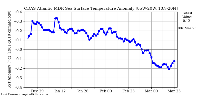
Water temperatures in the Atlantic Ocean’s Main Development Region (MDR) have generally trended downward in recent weeks and have slipped into below-normal territory. We’ll monitor this to see if the overall trend continues as we get closer to the summer (tropical) season. Map courtesy NOAA, tropicaltidbits.com
In addition to the inhibiting aspect for tropical activity helped along by El Nino, there are indications that the summer season may feature normal to below-normal water temperatures across the tropical Atlantic Ocean which is less favorable for tropical storm development and intensification. One final note on the potential impact of an El Nino, oceanic cycles are critical in terms of global temperature patterns: especially when dealing with the world’s largest (Pacific) ocean. There has indeed been a spike in global temperatures during some El Nino events; especially, those that reach very strong levels such as 1997-1998 and 2015-2016.
Meteorologist Paul Dorian
Arcfield
arcfieldweather.com
Follow us on Facebook, Twitter, YouTube
Video discussion: