
**Mid-week action from Texas to the Great Lakes with severe storm threat down south and ice/snow threat up north**
Paul Dorian
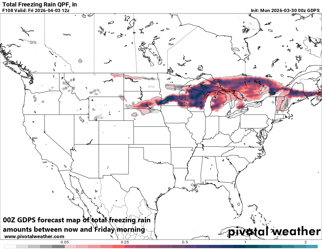
A significant icing event is on the table for later this week in the region from the Northern Plains to the Great Lakes with cold, Canadian air dropping south and east from central Canada at the same time warm, humid air pushes northward from the Gulf region. Map courtesy Canadian Met Centre, Pivotal Weather
Overview
Strong upper-level ridging that was parked over the Four Corner states in recent days has shifted to the east and this re-positioning will allow warm, moist air from the Gulf region to flow northward into the nation’s mid-section. One result of this changing weather pattern will be a much-increased chance of significant precipitation all the from Texas to the Great Lakes, and this can include strong-to-severe thunderstorms at mid-week. Farther north, there will be another influx of cold, Canadian air and this can lead to accumulating snow and perhaps significant icing across portions of the Northern Plains and Great Lakes later in the week.
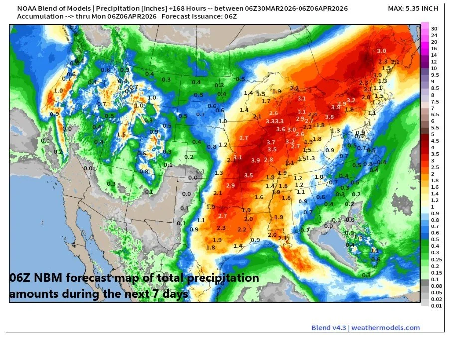
Precipitation amounts will be quite high during the next 7 days or so in the region from Texas to the Great Lakes. In many of these areas, any significant rainfall will be welcomed news as it has been quite dry across this section of the nation. Map courtesy NOAA, weathermodels.com
Details
Last week featured record high temperatures across much of the western US with intense high pressure ridging parked over the Four Corner states and in some cases, it was the warmest ever during the month of March (e.g., Denver, CO reached 87 degrees). The intense ridging aloft has since shifted to the east and temperatures will soar on Tuesday and Wednesday as a result in the Mid-Atlantic region with 80+ degrees on table.
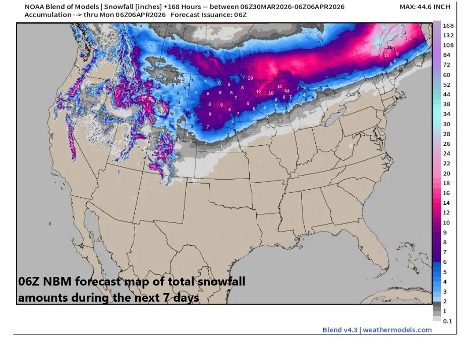
Snowfall can be substantial later this week from the Dakotas to the northern Great Lakes with several inches on the table in many of these areas. Map courtesy NOAA, weathermodels.com
Another change because of the re-positioning of the strong upper-level ridge will be an influx of warm, humid air into the nation’s mid-section and precipitation amounts are likely to be quite high during the next several days all the way from Texas to the Great Lakes...and this is welcomed in most areas. The influx of warm, humid air can contribute to a severe weather threat at mid-week in the southern and central Plains as energy aloft moves overhead. Specifically, there can be a line of strong-to-severe thunderstorms by later Wednesday night in the zone from Texas-to-Nebraska and this threat can extend northward into Iowa as well.
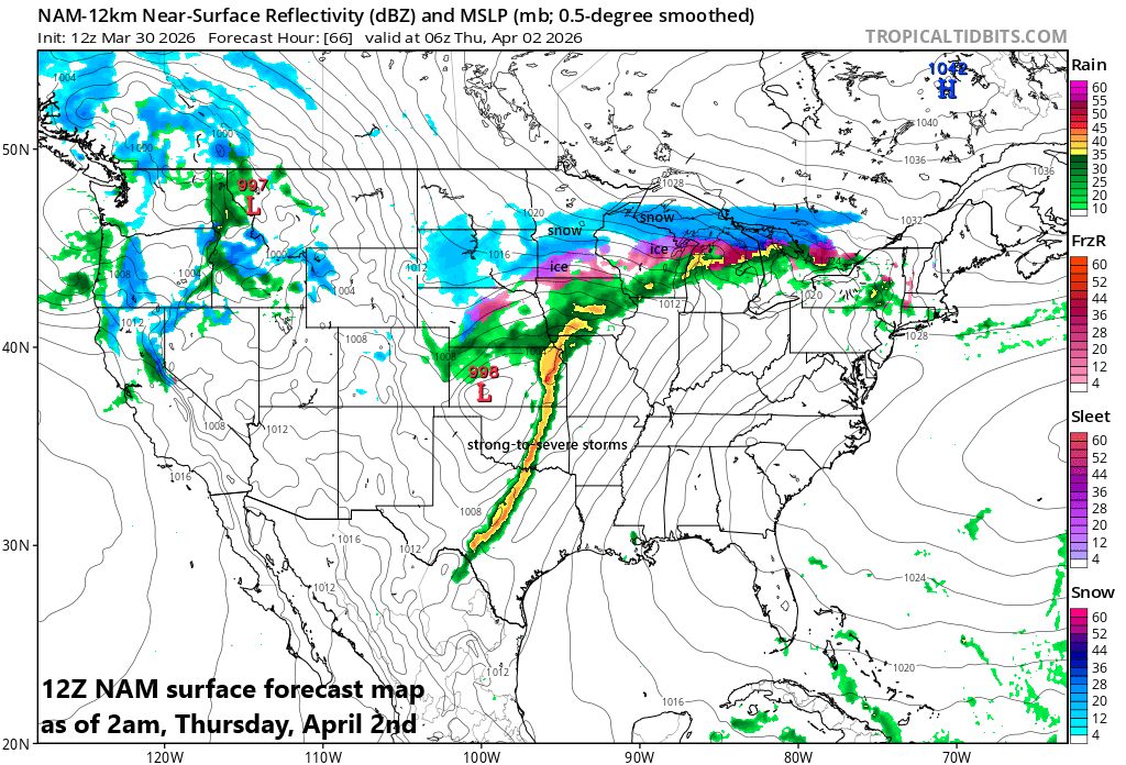
Lots of “colors” on the forecast weather map for Wednesday night which indicates the chance of strong-to-severe thunderstorm activity in the southern and central Plains and snow and ice up north across the Northern Plains and Great Lakes region. Map courtesy NOAA, tropicaltidbits.com
Farther north, there will be another influx of cold, Canadian air that feeds into the overall active weather pattern. As such, the region from the Northern Plains to the Great Lakes can experience accumulating snow by late Wednesday/Wednesday night and significant icing is on the table in this same part of the nation. The icing can be significant in places like Wisconsin, southern Minnesota and Upper Michigan and several inches of snow can fall from the Dakotas to the northern Great Lakes region. This combination of warm, humid air to the south and east and incoming colder air from the north and west will likely lead to multiple chances of rain across much of the eastern US later in the week and during the upcoming holiday weekend.
Meteorologist Paul Dorian
Arcfield
arcfieldweather.com
Follow us on Facebook, Twitter, YouTube
Video discussion: