Contact Us

Use the form on the right to contact us.

You can edit the text in this area, and change where the contact form on the right submits to, by entering edit mode using the modes on the bottom right. 


123 Street Avenue, City Town, 99999

(123) 555-6789

email@address.com


You can set your address, phone number, email and site description in the settings tab.
Link to read me page with more information.

backlit-stratus-clouds-2013-04-05.jpg

Blog

Weather forecasting and analysis, space and historic events, climate information

Filtering by Category: DC

7:00 AM | Mild into tomorrow, but Arctic cold arrives on Thursday

Paul Dorian

6-Day Forecast

Today

Becoming partly sunny after early clouds, quite mild, highs in the mid 60’s

Tonight

Mostly cloudy, mild, chance for some drizzle and patchy fog likely after midnight, lows near 50 degrees

Wednesday

Becoming partly sunny, breezy, still on the mild side, maybe a shower or two early, near 60

Wednesday Night

Mostly clear, breezy, turning colder, low 30’s

Thursday

Partly sunny, breezy, noticeably colder, mid 40’s; snow showers possible at night

Friday

Partly sunny, cold, chance for snow showers early, low 40’s

Saturday

Mostly sunny, cold, low 40’s

Sunday

Mostly cloudy, still cold, chance for rain or snow, mid 40’s
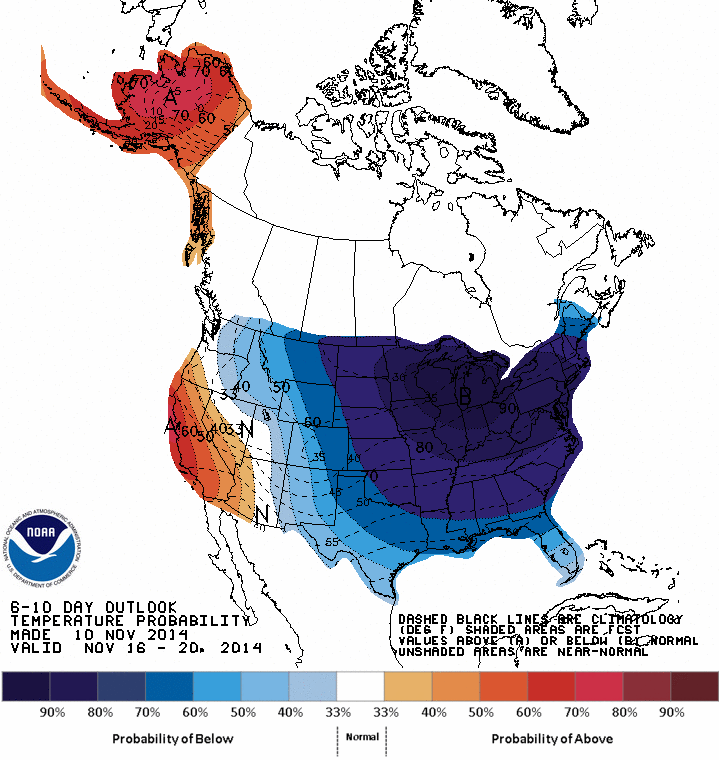
Discussion

Temperatures will climb into the 60’s today and will remain on the mild side on Wednesday before big changes take place on Thursday. An Arctic frontal system will slide through the region later tomorrow and temperatures on Thursday should hold in the 40’s. There can be some snow shower activity Thursday night into early Friday, but nothing significant, and the bigger weather story will be the influx of Arctic air. Once established, it appears as if this cold weather pattern will stick around for awhile in the Mid-Atlantic region and another Arctic blast – perhaps even colder than this initial outbreak - is destined to reach the US by the early part of next week.

Video

httpv://youtu.be/JZm2xPM98hY

3:45 PM | The Arctic invasion has arrived across the Rockies and Northern Plains

Paul Dorian

6-10

Discussion

Denver, Colorado enjoyed temperatures in the 70’s on Sunday and now they are in the 20’s with a screaming northerly wind and snowflakes in the air. Temperatures around Denver will likely bottom out tomorrow night near zero in a dramatic change since yesterday. Montana, Wyoming, and the Dakotas have suffered similar plunging temperatures today as the coldest air of the season so far makes serious in roads across the northern US. Accumulating snow is also accompanying the arrival of this Arctic air mass with the heaviest accumulations likely across central Minnesota and northern Wisconsin over the next 12-24 hours. Minneapolis, MN, for example, could end up with a foot of snow by early tomorrow from this first nasty round of winter’s wrath.

As the Arctic front pushes eastward it will lose some of its punch so that temperature departures from normal around here late this week will be only some 10-20 degrees below normal compared to the 30 to 40 degrees in parts of the Rockies and Northern Plains. The Arctic air will arrive around here on Thursday and high temperatures will generally hold in the 40’s as we close out the work week.

Looking ahead, all indications are that this cold pattern will stick around for awhile and reload this weekend and into next week. In fact, there are signs for another widespread Arctic outbreak next week across the eastern 2/3 of the nation that is likely to be colder than this current outbreak. There are also early signs for a storm to pull out of the southern states later next week and, if so, it’ll encounter lots of cold air as it progresses to the north and east. Stay tuned on that potential threat.

One of the drivers of this cold upper-level pattern is a massive developing ridge in the jet stream over the west coast of North America that is in part being pumped up by the remnants of this weekend’s monster storm over the Bering Strait in the Northern Pacific. Once this ridge fully develops over the next couple of days, it appears it will be in no hurry to leave keeping this cold pattern in place around here into at least Thanksgiving Week. Underneath this massive upper-level ridge will be a powerful surface high pressure system by mid-week over the northern Rockies with central pressures as high as 1050 millibars (31.01 inches). NOAA’s 6-10 day temperature outlook (above) for the period November 16th to 20th (next Sunday through Thursday) depicts the impressive extent of the high probability of colder-than-normal temperatures (blues, purples) extending across much of the nation.

7:00 AM | *Cold pattern sets up on Thursday and gets locked in*

Paul Dorian

6-Day Forecast

Today

Mostly sunny, nice, highs in the low 60’s

Tonight

Partly cloudy, cool, lows in the low 40’s

Tuesday

Mostly sunny, even milder, mid 60’s

Tuesday Night

Mostly cloudy, cool, maybe a shower or two late, mid-to-upper 40’s

Wednesday

Partly sunny, breezy, still mild, maybe a shower or two, low-to-mid 60’s

Thursday

Partly sunny, breezy, noticeably colder, mid-to-upper 40’s; chance for snow showers at night

Friday

Partly sunny, cold, chance for snow showers early, low 40’s

Saturday

Mostly sunny, still cold, low 40’s

Discussion

Temperatures will modify nicely today following a chilly weekend and should reach the 60 degree mark this afternoon and then climb well up into the 60's on Tuesday afternoon. Wednesday will stay on the mild side; however, an Arctic front will slide through the region and this will generate big changes for the region beginning on Thursday.

Arctic air is plunging today into the northern US from the hinterlands of northern Canada and accumulating snow will accompany this drastic change to cold in many areas from the Rockies to the Great Lakes. The heaviest accumulations over the next day or two will occur across central Minnesota and northern Wisconsin where 6-12 inches can fall as the Arctic air floods into that part of the country. The most dramatic change to cold will likely take place in Denver, Colorado where Sunday temperatures climbed into the 70's, but lows by late tomorrow night will drop to near zero accompanied by some snow. Temperatures here on Thursday will hold in the 40's and there can be some snow shower activity at night into early Friday, but the bigger story will be the influx of the Arctic air. We'll stay cold through the weekend and into early next week at which time another Arctic air mass will be heading in our direction as this cold weather pattern looks like it will stick around for awhile.

Video

httpv://youtu.be/0I9TtGPK_O0

11:30 AM | *Major cold wave next week and perhaps even the first threat of snow for the interior Mid-Atlantic*

Paul Dorian

Fri_night_fcst
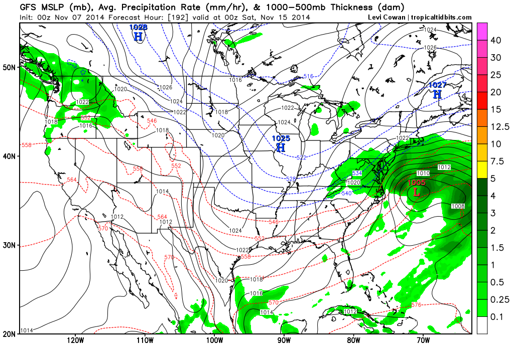
[00Z GFS surface forecast map for next Friday night; courtesy "tropicaltidbits.com"]

Discussion

The weather pattern across North America is about to undergo some significant changes over the next several days led in part by the development of a superstorm near the Bering Strait and this will play a role in multiple Arctic air outbreaks into the central and eastern US during the remainder of November. The remains of Typhoon Nuri are moving away from Japan today and into the Northern Pacific Ocean and will undergo explosive intensification over the next 12 hours as it closes in on the Bering Strait region between western Alaska and Russia. In fact, this storm may deepen enough by early tomorrow to rival all-time atmospheric low pressure records in that part of the world - perhaps as low as 925 millibars (27.28 inches!!!).

The development of a deep upper-level trough of low pressure in this part of the Northern Pacific associated with this unfolding superstorm will have ripple effects to the overall pattern downstream in coming days. To begin with, upper-level ridging will form along the west coast of North America in the next few days and then upper-level troughing will develop across the central and eastern US later next week. This type of pattern will allow for the movement of Arctic air from northern Canada into the northern US by the middle of next week. Indeed, one major Arctic air outbreak will plunge into the northern US by around Tuesday of next week and then this cold air mass will spread to the Mid-Atlantic coastline at mid-week. Shortly after the cold air establishes itself in the central and eastern US, the upper-level trof in that region will likely begin to deepen and the result could very well be the formation of a storm near the Mid-Atlantic coastline. With cold air in place and the potential development of a storm, this could turn out to be the first snow threat of the season in parts of the interior Mid-Atlantic region in the late Thursday/Friday time frame of next week. Stay tuned – the fun season is just getting underway.

Fri_night_fcst_temp_anon 
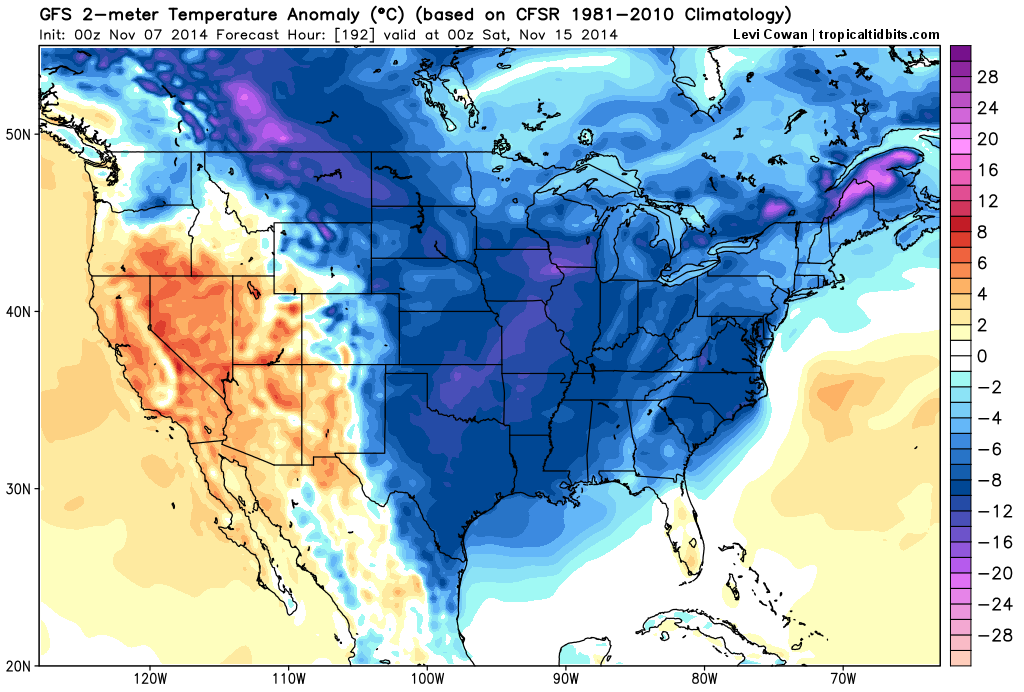
[00Z GFS 2-meter temperature anomaly forecast map for next Friday night showing widespread colder-than-normal air in the eastern 2/3 of the nation; courtesy "tropicaltidbits.com"]

7:00 AM | Colder air pushes in today on stiff NW winds and it stays chilly this weekend...temperatures drop to freezing or below for the first time late tonight in many suburban locations

Paul Dorian

6-Day Forecast

Today

Partly sunny, becoming windy, colder, chance for a lingering shower or two, highs in the low-to-mid 50’s

Tonight

Freeze warning…mostly clear, diminishing winds, cold, lows by morning near 30 degrees

Saturday

Mostly sunny, chilly, low 50's

Saturday Night

Mostly cloudy, chilly, maybe a shower or two late, near 40

Sunday

Partly sunny, chilly, maybe a shower, low-to-mid 50's

Monday

Mostly sunny, cool, mid-to-upper 50’s

Tuesday

Mostly sunny, not as chilly, near 60

Wednesday

Mostly cloudy, breezy, chilly, showers possible, upper 40’s

Discussion

Following last night’s cold frontal passage, colder air will pour into the Mid-Atlantic region today on stiff NW winds and it’ll stay quite cool through the upcoming weekend. A reinforcing cool air mass will arrive on Sunday keeping us on the cool side at the beginning of next week. Following that, a major cold shot will plunge from Canada into the mid-section of the nation early next week and then spread to the east coast by mid-week resulting in a very cold second half of the week. There is also the chance for a storm to form late next week near the coastline and the result would be a threat for rain and/or snow in the Mid-Atlantic region.

Video

httpv://youtu.be/tNMPV6CqBjM

7:00 AM | Occasional rain today as cold front approaches from the west...cooler weather moves in on Friday and lasts through the weekend

Paul Dorian

6-Day Forecast

Today

Cloudy and cooler today with occasional rain, highs near 60 degrees

Tonight

Evening showers likely; otherwise, remaining mostly cloudy, turning cooler late, lows by morning in the low-to-mid 40’s

Friday

Partly sunny, windy, colder, chance for a lingering shower or two, low-to-mid 50’s

Friday Night

Freeze warning...mostly clear, cold, lows near the freezing mark

Saturday

Mostly sunny, chilly, near 50; chance for a shower late at night

Sunday

Partly sunny, breezy, chilly, chance for a shower or two, low 50’s

Monday

Mostly sunny, chilly, low-to-mid 50's

Tuesday

Partly sunny, not as cool, near 60

Discussion

The combination of a warm front approaching from the south and a cold front approaching from the west will produce occasional rainfall in this area through early tonight. Following the cold frontal passage, colder air will move into the Mid-Atlantic region tomorrow on stiff NW winds and it’ll stay quite cool through the upcoming weekend. A reinforcing cool air mass will arrive on Sunday keeping us on the cool side during the early part of next week. Following that, a major cold shot that plunges from Canada into the mid-section of the nation early next week will likely reach the Mid-Atlantic region on Wednesday.

Video

httpv://youtu.be/eU_ODPh563s

7:00 AM | Occasional rain tomorrow to be followed by more chilly air for the end of the week and weekend

Paul Dorian

6-Day Forecast

Today

Mostly cloudy, still quite mild, highs in the mid-to-upper 60’s

Tonight

Mostly cloudy, mild, good chance for showers late, lows by morning in the lower 50’s

Thursday

Cloudy, a bit cooler with occasional rain, low 60’s

Thursday Night

Cloudy with lingering evening showers possible, cooler late, low-to-mid 40’s

Friday

Partly sunny, windy, colder, chance for a lingering shower or two, low-to-mid 50's

Saturday

Mostly sunny, chilly, near 50

Sunday

Mostly cloudy, chilly, chance for a few showers, low 50's

Monday

Partly sunny, breezy, chilly, near 50

Discussion

High pressure pushed off the east coast yesterday and this allowed milder air to push in from the southwest, but the warm up will not last much longer. After temperatures return to the 60’s this afternoon, a downward trend will begin on Thursday as low pressure develops in the Mid-Atlantic region. This storm will generate occasional rain in the area on Thursday and then another chilly air mass will follow on its heels at the end of the work week. That renewed chill on Friday will be accompanied by stiff NW winds and it’ll stay chilly right through the upcoming weekend. In fact, a reinforcing shot of cold air for this time of year will arrive on Sunday – not allowing for any significant warm up in between these back-to-back colder-than-normal air masses.

Video

httpv://youtu.be/KxZmfDB62e8

7:00 AM | Noticeable warm up for today and Wednesday...soaking rain on Thursday

Paul Dorian

6-Day Forecast

Today

Mostly sunny, pleasantly warm, highs in the mid-to-upper 60’s (normal high is now 63 degrees at DCA)

Tonight

Becoming mostly cloudy, mild, lows by morning in the lower 50’s

Wednesday

Mostly cloudy, still comfortably warm, mid-to-upper 60’s

Wednesday Night

Mostly cloudy, mild, chance for showers late, low-to-mid 50’s

Thursday

Cloudy, a bit cooler with periods of rain, maybe a thunderstorm, some of the rain can be heavy at times, low 60's

Friday

Partly sunny, windy, colder, chance for a lingering shower or two, near 50

Saturday

Partly sunny, chilly, near 50

Sunday

Mostly cloudy, chilly, maybe a few showers, near 50

Discussion

High pressure pushes off the east coast today and this will allow for the return of the milder air into the Mid-Atlantic region for the next couple of days. Temperatures today and Wednesday will climb well up into the 60’s in much of the I-95 corridor, but then it’ll turn slightly cooler on Thursday as low pressure forms in the Mid-Atlantic region. This low will likely generate a soaking rain event in the region from DC-to-Philly-to-NYC on Thursday before colder air returns behind it at the end of the week. While there can be a lingering shower or two on Friday, the more noticeable weather story as we close out the work week will be the strong NW winds and the renewed chill in the area. That late week chill will persist through the upcoming weekend and there will be a reinforcing shot of cold air by the early part of next week. In fact, November is looking more and more like it'll turn out to be a chilly month for this part of the country with wave after wave of cold air for this time of year.

Video

httpv://youtu.be/5qyWryqDXbM

7:00 AM | A nice rebound in temperatures right into mid-week...some rain likely on Thursday

Paul Dorian

6-Day Forecast

Today

After a cold start, it’ll turn milder today compared to yesterday with mostly sunny skies, highs in the upper 50’s

Tonight

Partly cloudy, cool, lows by morning in the low-to-mid 40’s

Tuesday

Mostly sunny, even milder, mid-to-upper 60’s

Tuesday Night

Mostly cloudy, mild, low 50’s

Wednesday

Partly sunny, mild, mid 60’s

Thursday

Cloudy, not quite as mild with rain likely, near 60

Friday

Partly sunny, breezy, cooler, chance for showers, low 50’s

Saturday

Partly sunny, chilly, near 50

Discussion

After starting off at some of the coldest temperatures seen so far this season, a warm up will begin this afternoon and by tomorrow afternoon highs should once again surpass the 65 degree mark. High pressure pushes off the east coast early this week and that will allow for the return of the milder air following our abnormally cold weekend in the Mid-Atlantic region. Later in the week, low pressure will form near the coastline and it will likely generate some rain in the region on Thursday. That storm system will be followed by another chilly air mass in time for the upcoming weekend.

Video

httpv://youtu.be/eQjGlG1mUfM

7:00 AM | Cold air blasts into the region this weekend as powerful storm forms off coast

Paul Dorian

6-Day Forecast

Today

Considerable clouds today, cool, highs in the upper 50’s

Tonight

Mostly cloudy, cool, chance for rain showers late, lows by morning in the upper 40’s

Saturday

Cloudy, becoming windy and unseasonably chilly, rain showers at times, maybe even a period of steadier rain, near 50 degrees

Saturday Night

Cloudy, windy, cold, chance for a few rain showers, maybe even a few snowflakes mixed in at times, lows towards morning in the mid 30’s

Sunday

Mostly sunny, windy, unseasonably cold, mid-to-upper 40’s

Monday

After an early start near the freezing mark, it'll be mostly sunny and stay quite chilly, but a bit milder than Sunday, mid 50’s

Tuesday

Partly sunny, milder, low 60's

Wednesday

Mostly cloudy, mild, low-to-mid 60’s

Discussion

A deep upper-level trough of low pressure will set up early this weekend in the Northeast US and the end result will be the development of a strong storm off the Mid-Atlantic coastline. Winds will increase noticeably around here tomorrow night and Sunday as the storm intensifies off the Mid-Atlantic coastline and then begins to move to the northeast. Rain showers will accompany the storm at times in this region from late tonight through Saturday evening and there could even be a period of steadier rain during the mid-day hours on Saturday. Also, it may get just cold enough tomorrow night for a few snowflakes to mix in as cold air floods into the region from the north. Sunday will feature the return of some sunshine to the Mid-Atlantic region, but the cold and wind will continue as high temperatures are generally held in the well-below normal 40’s. The best chance for a freeze around here from this upcoming cold blast will come "late Sunday night/early Monday morning" with lows expected at or just below the freezing mark in many locations and the period of "late Saturday night/early Sunday morning" won't be far behind with lows likely in the low-to-mid 30's. There will be a warm up in the Mid-Atlantic region by the middle of next week after the abnormally cold weekend.

Elsewhere, significant accumulations of snow are possible this weekend in mountainous regions to our southwest such as in eastern West Virginia, southwestern Virginia and western North Carolina. Also, accumulating snow can fall later in the weekend across portions of Maine as the powerful storm exits off to the north and east. This weekend cold blast could end up setting records in parts of the Southeast US from the Carolinas-to-Florida as the upper-level low digs way down the coast and the cold air follows.

One final note - it is time once again to turn back the clocks this weekend.

Video

httpv://youtu.be/keQEMNupfuE