Contact Us

Use the form on the right to contact us.

You can edit the text in this area, and change where the contact form on the right submits to, by entering edit mode using the modes on the bottom right. 


123 Street Avenue, City Town, 99999

(123) 555-6789

email@address.com


You can set your address, phone number, email and site description in the settings tab.
Link to read me page with more information.

backlit-stratus-clouds-2013-04-05.jpg

Blog

Weather forecasting and analysis, space and historic events, climate information

Filtering by Category: DC

7:00 AM | *Record lows this morning throughout the eastern and southern US; continued very cold this afternoon, but not nearly as windy as yesterday; much milder on Sunday and Monday, but also rainy at times*

Paul Dorian

record_lows

6-Day Forecast

Today

Mostly sunny today, but there will be an increase in clouds later this afternoon, continued very cold for this time of year, but not nearly as windy as yesterday, highs in the low-to-mid 30’s

Tonight

Becoming mostly cloudy, cold, but not nearly as extreme as last night, lows in the mid-to-upper 20’s

Thursday

Mostly sunny, not as harsh, becoming breezy, low-to-mid 40’s

Thursday Night

Mostly clear, breezy, quite cold, low 20’s

Friday

Mostly sunny, breezy, colder, mid-to-upper 30’s

Saturday

Mostly sunny, cold, low 40’s

Sunday

Mostly cloudy, noticeably milder, PM rain likely, low-to-mid 50’s

Monday

Mostly cloudy, quite mild, occasional showers, low-to-mid 60’s

Discussion

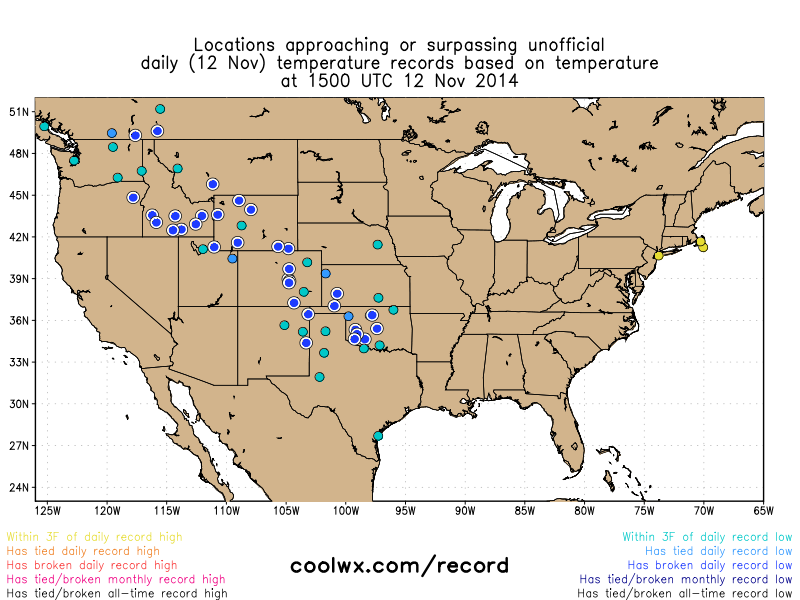
More than 170 records were broken this morning across the eastern and southern part of the country including many in the I-95 corridor region from DC-to-Philly-to-NYC. For example, low temperature records were broken today at the following airports: BWI (19°F), IAD (13°F), JFK (23°F), LGA (23°F) and PHL (20°F-tie). The map above shows the widespread extent of this record-breaking cold in the eastern and southern US with numerous record lows (blue/white circles) and even a few monthly low temperature records (black circles) [map courtesy coolwx.com].

Temperatures today will struggle to pass the freezing mark – way below normal for this time of year - but the wind will be noticeably less intense than yesterday. Temperatures should climb into the 40's on Thursday ahead of a reinforcing shot of Arctic air that will arrive tomorrow night and keep highs confined to the 30's once again on Friday as we close out the work week. Looking ahead, after a cold day to start the weekend, noticeably milder weather is in store in the region on Sunday and Monday, but this warm up will be accompanied by some rainfall.

Video

httpv://youtu.be/RPnsDQQCjfs

7:00 AM | *Painful cold today along with strong "slap-in-the-face" NW winds*

Paul Dorian

record_lows
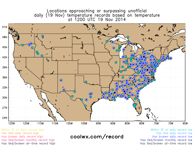
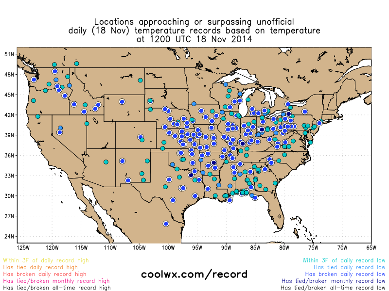
[Record or near record lows this morning virtually from coast-to-coast; map courtesy coolwx.com]

6-Day Forecast

Today

Mostly sunny, windy, painfully cold for mid-November, highs this afternoon will struggle to reach the 30 degree mark and wind chills will be noticeably lower at times

Tonight

Mostly clear, brutal cold for this time of year, lows in the mid-to-upper teens

Wednesday

Mostly sunny, still very cold, but not as windy, low 30’s

Wednesday Night

Mostly cloudy, quite cold, upper 20’s

Thursday

Mostly sunny, breezy, cold, low-to-mid 40’s

Friday

Partly sunny, breezy, colder, upper 30's

Saturday

Mostly sunny, cold, low 40’s

Sunday

Mostly cloudy, milder, chance for rain, low-to-mid 50’s

Discussion

Today will flat out be one of the coldest November days ever experienced in the Mid-Atlantic region and across much of the nation. This amazing Arctic outbreak is causing record or near record low temperatures this morning (blue circles) virtually from coast-to-coast with some cities experiencing their coldest temperature ever in the month of November (black circles) [above map courtesy coolwx.com]. Another outbreak of Arctic air has indeed arrived in the Mid-Atlantic region following yesterday’s storm system and evening cold frontal passage. Temperatures this afternoon will struggle to pass the 30 degree mark and then should plunge into the teens during the overnight hours – way below normal for mid-November. In addition, strong NW winds will make it feel even colder at times today with wind gusts up to 30 mph or so. The very cold conditions will continue tomorrow, but it won’t be as windy as today and then there will be a bit of moderation in temperatures on Thursday only to be followed by reinforcing cold air to end the week. Looking ahead, noticeable milder conditions are likely late this weekend and early next week, but the warmer weather will be accompanied by some rainfall.

Video

httpv://youtu.be/h6avANezMcU

12:00 PM | **Heavy rainfall today and then an historic cold blast with an amazing current nationwide snow cover extent**

Paul Dorian

snowpack[Current snow cover extent in the US is 50.4%; courtesy NOAA]

Discussion

Today's heavy rainfall The evening rush hour up and down the I-95 corridor from DC-to-Philly-to-NYC will likely be quite a mess with heavy rainfall likely through much of the afternoon and early evening hours in many of these locations. All of this rainfall comes ahead of an Arctic blast that’ll arrive in the overnight hours and it will turn out to be an historic cold blast in many areas of the eastern half of the nation over the next couple of days.

Historic Arctic blast In this part of the country, several records are in jeopardy during this upcoming cold snap that will feature the coldest air seen around here since February. What is coming our way? It is currently 12 degrees in Minneapolis, Minnesota with winds gusting to 26 mph - and its only mid-November. The most likely time for record-challenging cold around here is likely to come on Wednesday as temperatures should bottom out in the teens in the overnight hours leading into the early morning. The record low at Philly Airport (PHL), for example, on Wednesday, November 19th is 20 degrees set in 1936 and this one is in jeopardy. Dulles (IAD), VA has a chance to break the record for its coldest low and high temperature on both Tuesday and Wednesday. BWI Airport in Maryland has a good chance to have its coldest November 18 on record (Tuesday), as well as its coldest low and high temperature on November 19 (Wednesday). Amazingly, the high temperature expected tomorrow in DC (maybe only as high as freezing) is 10 degrees colder than the average high temperature in mid-January. State College, PA will be lucky to see their high temperature reach the lower 20's on Tuesday and their record low maximum is 27 degrees set in 1903.

This historic Arctic outbreak will not only affect the Mid-Atlantic region, but will extend from the northern Plains to the Deep South over the next few days. In fact, record lows will be challenged on multiple occasions through midweek from eastern Texas to the Carolinas with lows near freezing along much of the Gulf Coast. Parts of northern Florida may even have their first freeze of the season as lows dip down into the 20s in cities such as Jacksonville and Tallahassee.

Amazing current US snow cover Not surprisingly, the snow cover across the country has expanded significantly during the past 7 days or so. In fact, the current snow cover extent across the nation is around 50.4% which is the most we’ve seen (by a long shot) in the first half of November since 2003, when the National Snow Analysis archive begins. Only the year 2012 comes close to this year’s 50.4 percent coverage — on Nov. 12, 2012, 31.5 percent of the lower 48 was covered in snow. The normal snow cover extent nationwide at Christmas-time is around 33%. By the way, ice is already starting to appear on Lake Superior and it should expand significantly over the next few days. Last winter's relentless cold caused some record ice cover amounts in all five of the Great Lakes.

Looking ahead Milder weather is in sight for the eastern half of the nation. It looks like it’ll turn milder late this weekend and early next week; however, that warm up is likely to be accompanied by some more rainfall.

sat [Clouds associated with the Arctic front extend from the Gulf of Mexico to New England; courtesy NOAA]

7:00 AM | *Painful cold on Tuesday after a nasty, wet start to the week*

Paul Dorian

6-Day Forecast

Today

Periods of rain today and milder, highs not far from 50 degrees

Tonight

Rain ending early then becoming partly cloudy and quite breezy, turning sharply colder by morning with lows in the mid-to-upper 20’s

Tuesday

Mostly sunny, windy, painfully cold for this time of year, highs not far from 30 degrees

Tuesday Night

Mostly clear, brutal cold for mid-November, mid-to-upper teens

Wednesday

Mostly sunny, continued very cold for this time of year, but not nearly as windy, low-to-mid 30’s

Thursday

Mostly sunny, not as cold, mid 40’s

Friday

Partly sunny, breezy, cold, low 40’s

Saturday

Mostly cloudy, low-to-mid 40’s

Discussion

A storm is moving out of the Deep South this morning and is headed towards the Northeast US. It’ll bring us periods of rain today as we start the new work week with the steadiest and heaviest rain likely to fall from late morning through the afternoon when there can be some ponding on roadways. At the same time, Arctic air will be plunging into the Upper Midwest from southern Canada and this air mass will follow the storm here on Tuesday riding in on stiff NW winds. Temperatures tomorrow will struggle to pass the 30 degree mark in the DC metro region - way below normal for this time of year - and the wind chills will indeed make it a painful day for any outdoor activities. The very cold conditions will continue on Wednesday with high temperatures confined to the low-to-mid 30's and then we'll see a bit of a rebound on Thursday, but it'll still be well below normal for this time of year. Some noticeable moderation in temperatures will take place later this weekend and into the early part of Thanksgiving week, but it may be accompanied by more rainfall.

12:40 PM | An even colder Arctic air outbreak next week and an update on the Sunday night/Monday storm

Paul Dorian

temp_anom_tues_AM
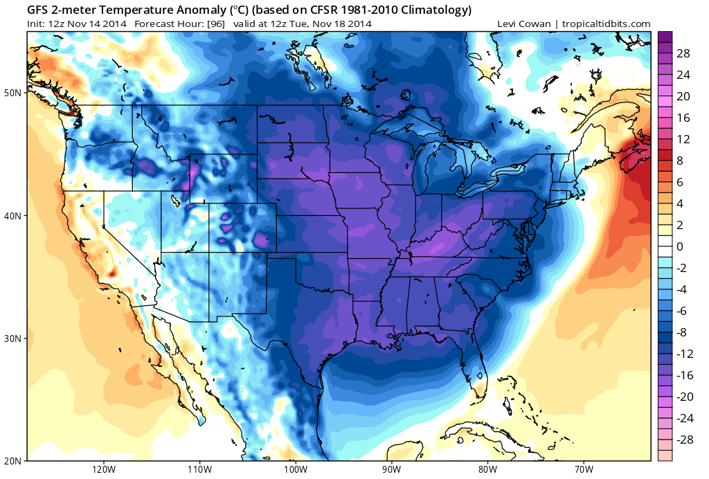
[Forecasted surface temperature anomalies for next Tuesday; map courtesy tropicaltidbits.com]

Discussion

It’ll remain cold this weekend and well below normal for this time of year, but an even colder air mass is destined to reach the Mid-Atlantic region on Tuesday. That next Arctic blast arrives on Tuesday with strong NW winds following a storm system that will impact our area to begin the new week. Temperatures on Tuesday and Wednesday are likely to hold in the 30’s for highs around here despite the return of some sunshine on each of those days. The 12Z GFS 2-meter temperature anomaly forecast chart for next Tuesday morning depicts the widespread below-normal cold throughout much of the nation (blues, purples; map courtesy tropicaltidbits.com). It’ll stay cold on Thursday as well, but moderation in temperatures is likely at the end of next week and into the beginning of Thanksgiving week.

As far as the Sunday night/Monday storm is concerned, odds favor rain during the bulk of this next event in the immediate I-95 corridor; however, it could be just cold enough at the onset early Sunday night for a mixture of rain, sleet and/or snow to occur for a brief time and there is a chance that the storm ends as a brief period of snow late Monday. No matter what type of precipitation actually falls on Sunday night and Monday - and primarily rain is expected - the coldest air of the season so far is sure to follow for Tuesday and Wednesday.

7:00 AM | Stays cold right through the weekend

Paul Dorian

6-Day Forecast

Today

Mostly sunny, breezy, cold, highs in the low 40’s

Tonight

Mostly clear, quite cold, lows in the middle 20’s

Saturday

Mostly sunny, continued cold, low 40’s

Saturday Night

Mostly clear, quite cold, mid-to-upper 20’s

Sunday

Becoming cloudy, cold, chance for rain at night possibly mixed with snow initially, mid 40’s

Monday

Cloudy, cold, periods of rain possibly mixing with or changing to snow near the end, low-to-mid 40’s

Tuesday

Partly sunny, windy, very cold for this time of year, upper 30’s

Wednesday

Mostly sunny, very cold for this time of year, upper 30’s

Discussion

Low pressure will push away from the coast this morning and sunshine will return to the region; however, it’ll remain colder-than-normal for this time of year. The cold weather pattern will continue right through the weekend and then we’ll have to deal with moisture coming out of the Deep South towards the Northeast US to start the new week. Odds favor rain late Sunday night and Monday in the immediate I-95 corridor, but it is a close call and it could turn out to be just cold enough for some type of a mixture in the northern and western suburbs initially and near the end of the storm. No matter what happens with this next storm at the beginning of next week, another blast of Arctic air will arrive on Tuesday following the storm and this next shot will be even colder than this week’s initial outbreak. Moderation in temperatures is likely by the end of next week.

12:10 PM | *First snow of the season*

Paul Dorian

sfc_map-06Z[GFS computer model surface forecast map for 1AM with snow (blue) in the immediate I-95 corridor and rain (green) closer to the coast; map courtesy tropicaltidbits.com]

Discussion

Low pressure will quickly ride up the east coast tonight along the Arctic frontal boundary zone that slipped through our region yesterday. An area of moisture associated with this developing low pressure system will push precipitation into the I-95 corridor at the end of the day and it will continue until after midnight. Initially, it’ll likely be a little too warm in the lower levels of the atmosphere for snow, but later this evening the precipitation should fall as all snow. A coating to an inch of snow is likely by late tonight across the northern and western suburbs along the I-95 corridor and even the big cities from DC-to-Philly-to-NYC can wake up to a touch of snow on grassy and other untreated surfaces. Watch for slick spots on the roads late tonight; especially, in the northern and western suburbs as temperatures should dip into the upper 20’s in some areas following the precipitation event.

The cold pattern that begins today will last through the weekend and right through next week. We’ll likely have to deal with another storm in the Mid-Atlantic region early next week. Odds favor rain in the immediate I-95 corridor for this next event late Sunday night and Monday, but it is a close call and it could be just cold enough for some type of mixture around here. No matter what happens with this next storm system at the beginning of next week, a new batch of Arctic air will flood into the Mid-Atlantic region on Tuesday following the storm and this next air mass will actually be colder than this week’s initial blast.

One final note: the early season cold has been quite incredible across the Rockies during the past few days with some temperatures 45 degrees below normal for this time of year. Casper, Wyoming reached -27°F early yesterday – their coldest temperature ever for November and we’re not even at the halfway point yet for the month. Denver, Colorado bottomed out at -14°F early today after being in the 70’s on Sunday – their 2nd coldest temperature ever in November. Finally, the average temperature earlier today across the continental US was 23.9°F which was the coldest reading since 1986 this early in the season.

7:00 AM | Noticeably colder today and the cold will not fold anytime soon; snow shower threat later tonight and possibly even the first coating of snow in suburban locations

Paul Dorian

6-Day Forecast

Today

Some sun followed by increasing clouds, noticeably colder than yesterday, chance for a rain shower late in the day, highs in the mid 40’s

Tonight

Cloudy, cold, rain showers early and snow showers late, a coating of snow is even possible in some of the northern and western suburbs, lows near 30 degrees

Friday

Becoming mostly sunny, breezy, cold, low 40’s

Friday Night

Mostly clear, quite cold, mid 20’s

Saturday

Mostly sunny, cold, low-to-mid 40’s

Sunday

Becoming mostly cloudy, cold, chance for rain at night possibly mixed with snow initially, mid 40’s

Monday

Cloudy, cold, rain likely, mid 40’s

Tuesday

Partly sunny, windy, very cold for this time of year, mid-to-upper 30's

Discussion

Let's begin with this...the first coating of snow is possible later tonight in some of the northern and western suburbs as low pressure moves up along the east coast at the same time even colder air filters into the region. An Arctic front slid through the region on Wednesday without much fanfare, but it has set in motion an overall weather pattern change that will likely keep the Mid-Atlantic region on the “colder–than-normal” side through next week and perhaps beyond. Temperatures today will hold in the 40’s and then an area of moisture associated with developing low pressure will ride along the coastline producing some rain early tonight and then snow later tonight in the northern and western suburbs. High temperatures tomorrow and for each weekend day will also hold in the 40’s and there is another Arctic air outbreak destined to reach this area next Tuesday - and it looks even colder than this initial shot of cold air. Before that next batch of Arctic air arrives, there is likely to be a storm that moves from the Gulf of Mexico into the Northeast US – odds favor rain in the immediate I-95 corridor for Sunday night and Monday, but we’ll monitor it closely over the next few days as it might just be cold enough at the start for a brief mixture.

Video

httpv://youtu.be/gKYfoOxDRV8

11:45 AM | Winds of change...colder air now moving in...snow shower threat later tomorrow night/early Friday

Paul Dorian

record_lows

Discussion

An Arctic front has slipped through the region and the winds throughout most of the Mid-Atlantic region have now shifted to a northwesterly direction (latest National Weather Service observations: http://www.wrh.noaa.gov/mesowest/gmap.php?zoom=7&extents=37.422526,-79.650879,42.472097,-70.532227&density=1/). This subtle change to the winds in speed and direction will not cause a dramatic temperature change around here as did the same frontal passage earlier in the week across the Rockies and Northern Plains, but it will set off a chain of events that will lead to a sustained “colder-than-normal” weather pattern here in the Mid-Atlantic region. Temperatures tonight will drop well down into the 30’s across the region and, as a second push of Arctic air arrives on Thursday, be held primarily in the 40’s for highs tomorrow afternoon. Once this cold pattern sets up, it’ll be tough to dislodge and it looks like it’ll stick around through much of the remainder of November.

As far as snow chances are concerned, the first threat for snow shower activity around here will come later tomorrow night into early Friday as an area of moisture rides up the coastline at the same time even colder air pushes in from the northwest. Another and more important storm is possible early next week as an area of deep moisture will likely move to the northeast from the Gulf of Mexico. Odds favor rain in the I-95 corridor, but this situation will be closely monitored over the next few days. Another Arctic blast will follow this next storm in the Tuesday/Wednesday time frame and this next shot will likely be even colder than this initial cold air outbreak.

Elsewhere, temperatures this morning were pretty incredible from the Pacific Northwest to the southern reaches of Texas with widespread record or near record lows (blue circled areas on plot; courtesy coolwx.com). Temperature departures from normal in parts of the Northern Rockies earlier today were in excess of 40 degrees. Perhaps the most impressive temperature reading was in Casper, Wyoming where an all-time November low temperature record was set at -26°F shattering the old record of -20°F set in 1947 (and we’re not even at the midway point for November).

7:00 AM | Arctic front slides through today...colder air arrives tonight and Thursday and then sticks around...comet landing update

Paul Dorian

6-Day Forecast

Today

Early morning low clouds, fog and drizzle will gradually give way to partly sunny skies, becoming breezy later today, but still on the mild side, highs near 60 degrees

Tonight

Mostly clear, quite breezy and turning noticeably colder, lows in the low-to-mid 30’s

Thursday

Mostly cloudy, breezy, cold, mid-to-upper 40’s

Thursday Night

Mostly cloudy, cold, chance for snow showers, near 30

Friday

Becoming mostly sunny after a possible early snow shower, cold, low 40’s

Saturday

Mostly sunny, cold, low 40’s

Sunday

Mostly cloudy, cold, chance for rain or snow at night, low-to-mid 40’s

Monday

Mostly cloudy, cold, chance for rain or snow, low 40’s

Discussion

An Arctic front will slide through the area today and this will set the wheels in motion for a rather sustained pattern change to “colder-than-normal” in the Mid-Atlantic region as we move through the rest of November. A cooling breeze will pick up later today out the northwest and continue through the night and this will begin to usher in the Arctic air mass that first invaded the Rockies and Central Plains earlier in the week. A secondary push of colder air will arrive on Thursday and this will help to confine temperatures tomorrow to the 40's and an area of moisture associated with this second front will ride up the coast tomorrow night and possibly generate some snow shower activity in the I-95 corridor. Highs on Friday and on both weekend days will remain at below normal levels generally in the 40's and then attention will turn towards the southern states as a storm could pull out of the Gulf of Mexico region early next week and bring rain or snow to the Mid-Atlantic region.

Elsewhere in the universe, the Philae lander separated from the mother ship Rosetta around 3:30 a.m. ET to begin its 7-hour descent to the comet known as 67P. Philae, which has spent 10 years fixed to the side of Rosetta during the journey across the solar system, cannot be steered. Once it was released, it was on its own. Mission controllers now face the long wait for Philae to reach the surface. The comet is so far away that a confirmation signal relayed from Rosetta, which remains in orbit around the comet, will take nearly half an hour to reach Earth. Scientists should have word around 11 a.m. ET. For more information on this story visit our "Space Events" page on the weather web site at http://vencoreweather.com/2014/11/10/1045-am-spacecraft-to-land-on-comet-early-wednesday-after-10-year-flight/.

Video

httpv://youtu.be/DViEhk4_VvE