Contact Us

Use the form on the right to contact us.

You can edit the text in this area, and change where the contact form on the right submits to, by entering edit mode using the modes on the bottom right. 


123 Street Avenue, City Town, 99999

(123) 555-6789

email@address.com


You can set your address, phone number, email and site description in the settings tab.
Link to read me page with more information.

backlit-stratus-clouds-2013-04-05.jpg

Blog

Weather forecasting and analysis, space and historic events, climate information

Filtering by Category: DC

7:00 AM | *Powerful nor'easter slowly relaxes its grip on the area*

Paul Dorian

6-Day Forecast

Today

Occasional snow winds down this morning; remaining mostly cloudy, windy, cold, highs in the low-to-mid 30’s

Tonight

Mostly cloudy, very cold, upper teens by morning

Wednesday

Mainly sunny, cold, low 30’s

Wednesday Night

Partly cloudy, very cold, middle teens for lows

Thursday

Becoming cloudy, cold, snow late in the day or at night, mid 30’s

Friday

Becoming partly sunny, breezy, cold, mid 30’s

Saturday

Mostly sunny, quite cold, near 30 degrees

Sunday

Mostly cloudy, quite cold, chance for snow, upper 20’s

Discussion

A powerful nor’easter is still wreaking havoc this morning with much of the Northeast US as it churns off the New England coastline. The worst of its impact now is occurring across Long Island (18" already at Islip) and New England where blizzard warnings remain in effect. Later today, the coastal low pressure system will begin to weaken as it heads towards the Canadian Maritimes. High pressure arrives here on Wednesday and then a clipper low is expected to throw some snow our way by Thursday night.

Video

httpv://youtu.be/SVg49BJ-Htg

1:30 PM | **Snow to become more widespread and pick up in intensity later this afternoon...worst impact from nor'easter tonight into Tuesday **

Paul Dorian

sat[Latest satellite image of developing coastal storm]

Discussion

This two-part event is now about to enter its second phase in which the rapidly intensifying nor’easter off the Mid-Atlantic coastline will take control. The combination of the relatively warm western Atlantic Ocean waters, strong upper level energy, and an influx of brutally cold Arctic air from the northwest will cause this coastal low to explode off the coast from later today into Tuesday. In general, snow will gradually become more widespread and pick up in intensity later this afternoon; however, banding will also be a feature in which periodic brief heavier snow bursts will take place in scattered locations. The main effects from the nor’easter will be felt later tonight continuing into Tuesday when heavy snow will occur along with some blowing and drifting. In some parts of the Northeast US; especially, in the region between New York City and Boston, “thunder snow” may also take place with enhanced snowfall for a brief period of time. The snow will be of the dry, fluffy variety - not like the wet snow that fell last Friday night.

Snow accumulations are likely to range quite a bit across the Philly metro region with the greatest amounts to the north and east and the least amounts to the southwest. For example, the western part of Chester County could end up with 3-6 inches range by later tomorrow whereas Bucks County and interior South Jersey just to the east of Philly wind up with 6-12 inches, even more that that possible in coastal New Jersey. In the DC metro region, there will also be variable amounts of snowfall ranging from two to as many as 4 or 5 inches by early tomorrow. Meanwhile, in the region between New York City and Boston, this could turn into one of the all-time great nor’easters with 1-2+ feet of snow, 50 mph winds and some serious blowing and drifting. The storm winds down later tomorrow from southwest-to-northeast - early afternoon in DC, late afternoon in Philly, early tomorrow night in NYC. Next snow threat arrives by Thursday night...frigid cold next week.

6:00 AM | ****Major nor'easter produces some accumulating snow around here, but dramatically worse to our northeast****

Paul Dorian

6-Day Forecast

Today

Snow or a mix of rain and snow will change to snow early today, snow will become steadier and heavier as the day progresses, breezy, cold, highs in the middle 30’s early

Tonight

Periods of snow, windy, very cold, blowing and drifting will occur, lows in the lower 20’s

Tuesday

Periods of snow early, windy, quite cold, total snow accumulations of 3-6 inches likely with the lesser amounts to the west (e.g., Virginia suburbs west of DC) and the higher amounts on the north and east side (e.g., PG, Montgomery Counties), upper 20’s

Tuesday Night

Partly cloudy, brutal cold, middle teens

Wednesday

Partly sunny, very cold, upper 20’s

Thursday

Becoming cloudy, cold, snow in the afternoon and at night, mid 30’s

Friday

Mostly cloudy, cold, maybe some lingering snow early, mid-to-upper 30’s

Saturday

Partly sunny, cold, mid 30’s

Discussion

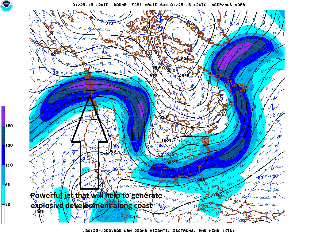
The potential exists for one of the all-time great nor'easters tonight and Tuesday in the region from New York City/New Jersey-to-Boston. This will be a two-part event with the first part lasting into early afternoon associated with a “clipper” type of system. Snow this morning will be sporadic and can even be mixed with rain for a bit longer, temperatures are generally still above freezing limiting accumulations to small amounts. Then, once this system reaches the western Atlantic Ocean later today, the combination of the relatively warm ocean water, a powerful upper-level jet streak and an influx of brutally cold Arctic air from the northwest will cause it to explode off of the Northeast US coastline. As the mid-day and afternoon progress, the snow will become steadier and heavier with the brunt of the storm occurring here from later today into early Tuesday. There will be some blowing and drifting of snow later tonight and on Tuesday as winds crank up out of the northeast. The snow later during the brunt of the storm will be of the dry, fluffy variety.

The worst impact of the storm will be in northern and eastern sections of the DC metro region. Snowfall accumulations by the time the storm winds down late tomorrow could range somewhat widely across the area with western sections such as near Dulles Airport experiencing only a few inches inches and areas to the north and east (Montgomery, PG Counties) experiencing as much as 6 inches or so. One last point, the overall weather pattern looks absolutely frigid for the foreseeable future – perhaps right through February -and there will be multiple snow threats with the next one arriving late Thursday into Friday. The cold shot that arrives in about a week could bring record-breaking cold into the Northeast US as we begin the month of February.

Video

httpv://youtu.be/8gdXdUWptjI

10:00 AM | *****Major disruptive snowstorm potential from Philly-to-Boston later Monday into Tuesday; DC area in the game as well and gets accumulating snow*****

Paul Dorian

wv-l

Discussion

Overview The potential exists for one of the great all-time nor'easters in the region from New York City/New Jersey-to-Boston. If you have some bare ground on your lawn, you may want to take a good look at it now as it will likely not be visible after today for many, many weeks. There will be accumulating snow over the next 48 hours in the Mid-Atlantic region and it will be subtantial in many areas. In addition, there will be multiple bitter cold Arctic air outbreaks during the next few weeks which will make sure that the snow sticks around for a long, long time. This will be a two-part event with the first part associated with a "clipper" from later tonight into tomorrow afternoon and in this time period any snow that falls can be mixed with rain primarily south of the PA/MD border. Then, energy from this system will feed into a coastal low which will develop explosively later tomorrow and tomorrow night as it heads to the northeast from the Carolina coastline producing snow (no more mixing issues) in the I-95 corridor.

“Clipper” type system Sunday night into Monday afternoon An Arctic front slides through the region today setting the stage for the development of a major coastal storm during the next 48 hours. A “clipper” type of system now over the Mississippi Valley (water vapor image) is moving east-to-southeast today and it will reach the coastal waters of the western Atlantic Ocean by later Monday. Snow will move into the I-95 corridor region tonight, perhaps mixed with rain south of the PA/MD border. Precipitation will become all snow by tomorrow morning and continue into the afternoon. By this time, there can be a few inches of snow in the DC and Philly metro regions with lesser amounts to the north near New York City. The main action, however, begins late tomorrow and early tomorrow night; especially, from Philly and points to the north and east.

Explosive nor’easter Monday night into Tuesday Once this system reaches the western Atlantic Ocean later tomorrow, the combination of the relatively warm ocean water, a powerful upper-level jet streak (below), and an influx of brutally cold Arctic air from the northwest will cause it to explode off of the Northeast US coastline from later Monday into Tuesday. As a result, snow will intensify by tomorrow night in the I-95 corridor region from Philly northeastward and perhaps even all the way down to the DC metro region. This snow will be of the dry, fluffy variety - not like the wet snow that fell Friday night. This could turn into an all-out blizzard by tomorrow night and Tuesday from Philly northeastward with heavy snow, strong winds and bitter cold. Blizzard conditions are likely in coastal areas from New Jersey northeastward to the New England coastline.

By the time Tuesday morning rolls around, there can be up to 6 inches or more of new snow in DC, a foot or more in Philly region, and 20-30 inches likely from NYC-to-Boston where it looks likely that this storm will be talked about for a long time. One last point, the overall weather pattern looks absolutely frigid for the foreseeable future – perhaps right through February - and there will be multiple snow threats with the next one arriving late Thursday into Friday. The cold shot early next week as we begin the month February could be record-breaking in the Northeast US.

250mb_jet_streak

11:45 AM | **Snow tomorrow night and Monday from a system that will then explode off the Northeast US coastline…more accumulating snow possible here Monday night/Tuesday along with brutal cold air…as far as the longer-term is concerned – buckle up for that as well!**

Paul Dorian

Discussion

Sunday night/Monday As today’s coastal storm affects wind down along the I-95 corridor, another storm is already taking shape upstream. A “clipper” type of system is dropping southeastward today into the Northern Plains and it will reach the coastal waters of the western Atlantic Ocean by later Monday. Snow will move into the I-95 corridor region tomorrow night and continue on Monday with a big impact likely on the Monday morning commute along with possible school closings. This snow will be of the dry, fluffy variety - not like the wet snow that fell last night. Preliminary snowfall estimates by later Monday afternoon are as follows: DC region 3-6 inches, Philly region 3-6 inches, NYC region 2-4 inches.

Monday night/Tuesday Once this system reaches the western Atlantic Ocean later Monday, the combination of the relatively warm ocean water and an influx of brutally cold Arctic air from the northwest will cause it to explode off the Northeast US coastline from late Monday into Tuesday. As a result, more accumulating snow could fall in the I-95 corridor on Monday night and Tuesday and it could be substantial. New England is quite likely to get walloped by an all-out wind-blown blizzard on Monday night and Tuesday and the I-95 corridor region from DC-to-Philly-to-NYC is going to be a close call. Brutal cold air reaches our region Monday night and it’ll last for much of the week. In fact, the overall weather pattern looks absolutely frigid for the foreseeable future – perhaps right through February -and there will be multiple snow threats.

10:00 AM | ****Unfolding weather pattern to bring significant snow and brutal cold to the Mid-Atlantic region during the next few weeks and perhaps right through the month of February****

Paul Dorian

Discussion

Overview Some winters in the Mid-Atlantic region never bring significant snow. Some winters never feature the brutal cold that winter can offer. It is quite likely that we’ll get to experience both significant snow and brutal cold here in the Mid-Atlantic region during the next few weeks and that type of pattern with snow and cold could actually last right through the month of February. There will be numerous snow threats along the way beginning with the one from this evening into Saturday and then a second from Sunday night into Monday. In addition, brutal cold air outbreaks are likely to make numerous visits here as well during the next couple of weeks with the first one to arrive by Tuesday of next week. In fact, low temperatures by Wednesday morning could be sub-zero in many parts of the Northeast US and single digits in the I-95 corridor region from DC-to-Philly-to-NYC.

An especially interesting and scary-looking time period will be as we end January and begin February. Not only are there signs for a major coastal storm around February 1st (Super Bowl Sunday) or so, but brutal cold is likely to follow during the first few days of February that could bring temperatures to near zero again in many places across the Northeast US (see forecast map below for 2-meter temperature anomalies in the 5-day period from 2/2 to 2/7).

Feb_cold 
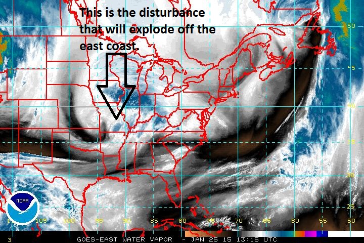
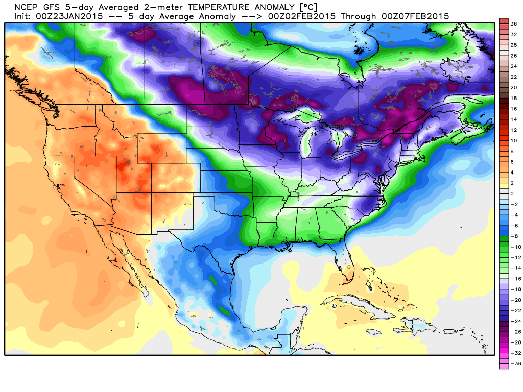
[GFS 2-meter temperature anomaly forecast map for 5-day period of 2/2-2/7; map courtesy Weather Bell Analytics at weatherbell.com]

Temperatures and the connection to the 500 millibar height anomaly pattern One week ago we discussed the likelihood for strong ridging to develop along the west coast of North America as we progress into the latter part of January. Indeed, the forecast map (below) from yesterday’s 12Z GFS Ensemble run for February 1st continues to insist on strong ridging (oranges) along the west coasts of Canada and the US and this type of upper air pattern usually leads to multiple Arctic air mass incursions into the northern US from northern Canada. In fact, this forecast map suggests that the upper-level winds at 500 millibars – which tend to follow the height anomaly lines - could actually bring air directly from the North Pole into the northeastern US by the beginning of February.

f228 
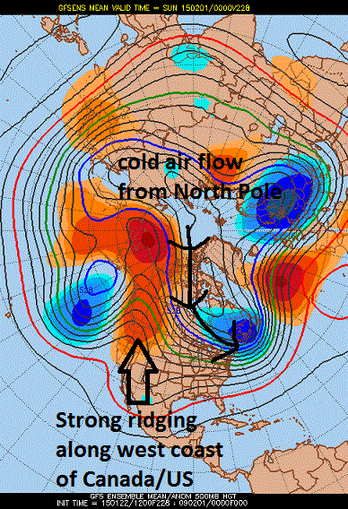
[GFS Ensemble height anomaly forecast map for February 1st; courtesy Penn State eWall]

Short-term snow threats Tonight/Saturday Precipitation from an intensifying coastal storm should reach the DC metro region early this evening (5pm or so), the Philly region between 9pm – 11pm, and NYC between 1 and 3am. The main thumping of snow from this system will be on its front end before a changeover takes place to freezing rain and sleet and perhaps even to plain rain from the cities to the coast. This event is likely to end in the DC metro region by early tomorrow afternoon, late afternoon in Philly and early evening in NYC. Snow and ice accumulation estimates are as follows:

1-3 inches in the northern and western suburbs of the District; lesser amounts in DC and points south and east 3-6 inches in the Philly and NYC metro regions and in their northern and western suburbs; lesser amounts to the south and east

Sunday night/Monday Another system will drop southeastward across the Great Lakes region late Sunday in much the same manner as some of the recent “clippers”. This system, however, has more potential than those as it will intensify in the Mid-Atlantic region on Monday, tap into some coastal moisture, and will have a cold air mass in place as it arrives. As a result, snow is likely to be the dominate precipitation type with this system on Sunday night and Monday and anywhere from several inches of snow are possible from DC-to-Philly-to-NYC. There is quite likely to be a significant disruption with the Monday morning commute due to the snowfall.

Buckle up, it’s going to be a wild ride.

Video

httpv://youtu.be/clS8roYhJ8k

6:00 AM | **Winter storm arrives early this evening...another storm generates accumulating snow here Sunday night into Monday**

Paul Dorian

6-Day Forecast

Today

Increasing clouds, cold, snow or snow and sleet arrives at the end of the day, highs near 40 degrees

Tonight

Cloudy, cold, snow or snow and sleet early this evening likely mixing with freezing rain late, lows in the lower 30’s

Saturday

Mixed precipitation changes to plain rain except possibly in the far northern and western suburbs where freezing can still occur, cold, total snow and ice accumulations in the 1-3 inch range are likely in the northern and western suburbs of the District, lesser amounts in the District and points south and east, upper 30’s

Saturday Night

Becoming partly cloudy, cold, mid-to-upper 20’s

Sunday

Partly sunny, cold, mid-to-upper 30’s; snow likely at night

Monday

Mostly cloudy, snow likely, cold, mid 30’s

Tuesday

Mostly sunny, very cold, upper 20’s

Wednesday

Partly sunny, very cold, upper 20’s

Discussion

A significant coastal storm will move from the Virginia coastline early tomorrow to just east of the Massachusetts coastline by Saturday night and the result will be some accumulating snow and ice in the I-95 corridor. This storm will undergo rapid intensification between tonight and tomorrow night as it treks northeastward just off the east coast. One important limiting factor for significant snow from this storm in the Mid-Atlantic region is the fact that there will be no Arctic air mass in place ahead of the system and no strong high pressure system will be located to the north during the event acting as an all-important cold air source. Nonetheless, despite a likely mixture of precipitation during this event, total snow and ice accumulations in the 1-3 inch range are likely in the northern and western suburbs of the District given the expected storm track and rapid intensification which can "generate" its own cold air. The main thumping of snow from this storm will come on its front end later this evening.

Another system will drop southeastward across the Great Lakes region late Sunday in much the same manner as some of the recent “clippers”. This system, however, has more potential that those recent ones as it will intensify in the Mid-Atlantic region on Monday, tap into some Atlantic Ocean moisture, and will have a cold air mass in place as it arrives. As a result, snow is likely to be the dominate precipitation type with this system on Sunday night and Monday and several inches of snow accumulation is possible from DC-to-Philly-to-NYC. There is the strong likelihood that the Monday morning commute will be significantly disrupted by this early week snow event. Brutal cold air follows this second system and lows by Wednesday morning will likely reach the single digits.

Video

httpv://youtu.be/clS8roYhJ8k

1:10 PM | **Two upcoming shots at accumulating snow...Friday night/Saturday; Sunday night/Monday**

Paul Dorian

gfs_mslp_pcpn_frzn_us_8[12z GFS forecast map for early Saturday; courtesy tropicaltidbits.com]

Discussion

Overview A significant coastal storm will move from the Carolina coastline early Saturday to just off the New England coastline by Saturday night and the result should be some accumulating snow in much of the I-95 corridor. This storm will undergo rapid intensification as it treks northeastward during the day Saturday. One important limiting factor for significant snow from this storm in the Mid-Atlantic region is the fact that there will be no Arctic air mass in place ahead of the system and no strong high pressure system will be located to the north during the event acting as an all-important cold air source. Nonetheless, despite a likely mixture of precipitation during this event, snow accumulations are still possible in the DC-to-Philly-to-NYC corridor given the expected storm track and rapid intensification which can "generate" its own cold air.

Another system will drop southeastward across the Great Lakes region late Sunday in much the same manner as some of the recent “clippers”. This system, however, has more potential as it will intensify in the Mid-Atlantic region on Monday and it will have a cold air mass in place as it approaches. As a result, snow is likely to be the dominate precipitation type with this system on Sunday night and Monday and accumulations are likely.

Round One Precipitation from the early weekend coastal storm should reach the DC metro region between 7 and 11pm on Friday night, Philly region between 9pm - 1am (Sat), and NYC between 3 and 6am early Saturday morning. Precipitation is likely to fall as snow at the onset and accumulations are quite likely by Saturday morning in the DC and Philly metro regions. The snow is likely to then change to rain or a mix of rain, sleet and snow on Saturday before possibly changing back to all snow later in the day. This event is likely to end in the DC metro region by early-to-mid Saturday afternoon, late afternoon-to-early evening in Philly and later in the evening in the NYC metro region. Preliminary snow accumulation estimates (still subject to change) are as follows:

1-3 inches in DC and in its N and W suburbs 3-6 inches in Philly and NYC and in their N and W suburbs Lesser amounts to the south and east of these big cities

Round Two The second storm will likely produce accumulating snow later Sunday night into Monday and it is likely to have an impact on the Monday morning commute.

7:00 AM | *"Clipper" is gone...attention now turns to an east coast early weekend storm*

Paul Dorian

6-Day Forecast

Today

Becoming partly sunny, cold, highs near 40 degrees

Tonight

Partly cloudy, cold, lows in the mid 20’s

Friday

Mostly sunny, cold, near 40 degrees

Friday Night

Increasing clouds, cold, snow after midnight, mid-to-upper 20’s

Saturday

Snow changing to rain or a mixed bag and then possibly changing back to all snow, upper 30’s

Sunday

Mostly sunny, breezy, cold, near 40 degrees

Monday

Mostly cloudy, cold, more snow likely, upper 30’s

Tuesday

Partly sunny, quite cold, low 30’s

Discussion

Now that the relatively weak “clipper” system has moved away from the Mid-Atlantic region, attention will turn to the next event and this could be a significant east coast storm. After a couple of quiet days to end the work week, copious amounts of moisture will ride up the coast late Friday night and Saturday and this should lead to accumulating snowfall in much of the I-95 corridor. While there will be no Arctic air in place ahead of the storm - usually a pre-requisite for significant snow in the I-95 corridor - there will be incredible intensification of the surface low pressure system and this process can actually “generate” its own cold air. For an idea as to how rapidly this storm may intensify and how deep it may become as it treks from the Mid-Atlantic to New England coastline, here are the 24-hour central pressure readings as predicted by yesterday's European computer forecast model between late Friday and late Saturday: 1003 mb --> 996 mb --> 984 mb --> 969 mb --> 959 mb (44 millibars in 24 hours; 959 millibars equals 28.30 inches). Stay tuned, there are still a couple of days to go before the event and the positioning of the "rain/snow" line is certainly not set in stone which is critical to snowfall totals.

2:40 PM | **An update on the "clipper" snow and the major east coast early weekend storm threat**

Paul Dorian

Discussion

An all-out major snowstorm is still on the table in the I-95 corridor from DC-to-Boston for late Friday night and Saturday and this will not be the only serious snow threat that we’ll encounter over the next couple of weeks. In fact, there appear to be multiple snow threats coming during the next couple of weeks and also some serious cold air outbreaks. The early weekend storm will be the type that can produce a foot or more of snow in parts of the I-95 corridor, but there are still some questions that remain at this point and it is still a few days away. For an idea as to how rapidly this storm may intensify and how deep it may become as it treks from the Mid-Atlantic to New England coastline, here are the 24 hour central pressure changes as predicted by the latest European computer model forecast: 1003 mb --> 996 mb --> 984 mb --> 969 mb --> 959 mb (44 millibars in 24 hours; 959 millibars equals 28.30 inches).

In the meantime, today’s “clipper” system has produced on average a 1-3 inch snowfall across DC and its northern and western suburbs. The snow there will taper off later this afternoon from southwest-to-northeast. In Philly, the snow which had been inhibited in its advance by low-level dry air, will intensify somewhat going into the late afternoon and it should continue through much of the evening producing on average a coating to a couple of inches. The NYC metro region will be on the northern fringes of this “clipper” system with little in the way of snow accumulation. One final note, after the snow "lightens" up this evening in the I-95 corridor and the "dynamic cooling" ends in the atmosphere, there is liable to be a period of freezing drizzle which could make roadways quite slick. Quiet weather will close out the work week on Thursday and Friday, but then attention will turn to the east coast for what could turn out to be quite a blockbuster nor’easter.