Contact Us

Use the form on the right to contact us.

You can edit the text in this area, and change where the contact form on the right submits to, by entering edit mode using the modes on the bottom right. 


123 Street Avenue, City Town, 99999

(123) 555-6789

email@address.com


You can set your address, phone number, email and site description in the settings tab.
Link to read me page with more information.

backlit-stratus-clouds-2013-04-05.jpg

Blog

Weather forecasting and analysis, space and historic events, climate information

Filtering by Category: DC

7:00 AM | Temperatures climb through the 40's this afternoon, but Arctic cold returns tomorrow

Paul Dorian

6-Day Forecast

Today

Becoming partly sunny and noticeably milder, highs should reach the upper 40’s

Tonight

Mostly cloudy, turning colder, chance for snow showers late, lows in the upper 20's by morning

Thursday

Snow showers possible early then becoming partly sunny and windy, temepratures hold steady near 30 degrees early then drop during the afternoon hours

Thursday Night

Windy and brutally cold with partial clearing, lows not far from 10 degrees

Friday

Mostly sunny, cold, low 30’s

Saturday

Mostly cloudy, milder, mid 40’s

Sunday

Mostly cloudy, cold, chance for snow, sleet and/or rain, upper 30’s

Monday

Mostly cloudy, colder, chance for snow, low-to-mid 30’s

Discussion

Temperatures will moderate today – perhaps even flirting with the 50 degree mark in the metro region – but another Arctic invasion is ready to pounce on the northeastern US. A strong Arctic front will arrive early tomorrow and it should produce snow showers in the area late tonight and early Thursday. More bone-chilling cold will follow with strong winds later tomorrow into Friday before moderation takes place to begin the weekend. That moderation on Saturday will be short-lived; however, as another cold shot will arrive later in the weekend leading to a period of inclement weather. A mixed bag of precipitation is possible around here on Sunday and then, as it turns gradually colder on Monday, snow very well could become the main precipitation type early next week as low pressure tries to form near the Mid-Atlantic coastline.

Video

httpv://youtu.be/AUZS20v35Vc

7:00 AM | Much colder air today and another Arctic shot later this week could be accompanied by snow showers

Paul Dorian

6-Day Forecast

Today

Partly sunny, breezy, quite cold, highs in the low 30’s

Tonight

Mostly cloudy, quite cold, lows in the low 20’s

Wednesday

Partly sunny, milder, mid 40’s

Wednesday Night

Mostly cloudy, cold, snow showers possible late, upper 20’s

Thursday

Mostly cloudy, colder, snow showers possible early, low 30’s

Friday

Mostly sunny, very cold, upper 20’s

Saturday

Partly sunny, milder, low-to-mid 40's

Sunday

Mostly cloudy, colder, chance for snow or rain, mid 30’s

Discussion

Arctic air plunged into the Mid-Atlantic region late yesterday and temperatures today will be confined to well below normal levels for this time of year. After noticeable modification in temperatures on Wednesday, another Arctic cold front will arrive late Wednesday night/early Thursday and it is likely to be accompanied by some snow shower activity. Brutal cold Arctic air will follow that system for Thursday night and Friday along with bone-chilling winds.

Looking ahead, after a milder day on Saturday, signs point to another possible snow and/or rain event in the DC metro region in the Sunday/Monday time frame of next week. Elsewhere, yesterday's storm produced the 5th largest snowfall ever in Chicago, the 3rd largest in Detroit, and let's just say Boston is off the charts. Another foot of snow in the Boston area on Monday pushed some accumulation totals to nearly 50 inches in less than a week (throw in a Super Bowl championship and it makes for an interesting week).

7:00 AM | **Winds increase dramatically during the mid-day and afternoon hours with gusts to 50 mph possible later today and again tonight...temperatures will drop this afternoon and then plunge overnight**

Paul Dorian

6-Day Forecast

Today

Some light rain or drizzle this morning along with areas of fog, winds pick up dramatically this afternoon and temperatures will begin a downward trend, highs by mid-day reach 40 degrees, but drop this afternoon

Tonight

Very windy, becoming brutally cold with partial clearing, lows by morning near 15 degrees

Tuesday

Mostly sunny, breezy, very cold, near 30 degrees

Tuesday Night

Mostly cloudy, very cold, low 20’s

Wednesday

Mostly cloudy, milder, highs near 45 degrees

Thursday

Mostly cloudy, colder, chance for snow showers, near 30 degrees

Friday

Mostly sunny, quite cold, upper 20’s

Saturday

Partly sunny, not as cold, mid-to-upper 30’s

Discussion

Low pressure is reforming off of the Mid-Atlantic coastline this morning and the northward advance of the warming has grinded to a halt. In fact, this afternoon will feature a pickup in the winds and temperatures will begin a downward trend as colder air pushes to the south from the north. Winds could actually gust to 45 or 50 mph later today and tonight as the departing storm intensifies off the northeast coastline. Low temperatures by early tomorrow are likely to be in the neighborhood of 15 degrees or so in much of the region. After a cold Tuesday, it’ll turn milder on Wednesday before another cold shot arrives in time for Thursday and Friday.

Video

httpv://youtu.be/9MXFxTENwb8

11:00 AM | **Main action of the upcoming winter storm holds off until after dark...snow, sleet, freezing rain, and plain rain coming to the Mid-Atlantic region with amounts dependent on location**

Paul Dorian

wv-l[GOES water vapor image with lots of moisture headed our way from the Midwest/Central Plains]

Discussion

Overview A ton of moisture is headed to the Mid-Atlantic region and with temperatures near or below the freezing mark in many areas there can be a significant buildup of ice later tonight after some initial snowfall at the onset. The low pressure center will move from southern Indiana today to southwestern Pennsylvania by tomorrow morning at which time it will then tend to reform off of the New Jersey coastline. Warmer air at many levels of the atmosphere will advance northward into southern and central Pennsylvania during this storm, but eventually this northward movement will grind to a halt due to a developing blocking pattern over Greenland and the NW Atlantic Ocean and that is where a battle will take place.

North of the PA/MD border There is the chance for some snow later this afternoon in SE PA, NJ and NYC, but the main action begins later this evening. Given the current storm track, warmer air at upper levels of the atmosphere will advance as far north as central Pennsylvania and this will allow for any initial snow to mix with or change over to sleet and freezing rain later tonight where a buildup of ice can occur in the overnight hours. By tomorrow morning, temperatures could edge above freezing in southern sections of the Philly metro region, but they’ll be hard-pressed to rise above the freezing mark in the northern half of the region and in areas north and east of there (e.g., Lehigh Valley, NYC). An influx of colder air on the back end of the storm could bring a changeover of the precipitation back to all snow later Monday.

South of the PA/MD border While there can be snow later today in areas near the DC metro region, the main action begins later this evening with some snow at the onset or a mix of snow, sleet and freezing rain. As warmer air advances northward later tonight, temperatures will rise above freezing and the precipitation will change to plain rain except for perhaps some sections near the PA/MD border where icing may linger for a little longer. As a result, the region extending from DC to southern New Jersey will likely see minimal accumulations of snow and ice, but there can be some slippery spots during the first part of the storm late today or during the evening hours. Winds will pick up quite a bit later Monday as the storm pulls away to the northeast and intensifies.

Current estimates for this complicated forecast are as follows (storm timetable from late today to late Monday):

DC metro region: a coating to 2 inches of snow and ice; snow changes to sleet, freezing rain and then to plain rain by Monday morning

Southern New Jersey: a coating to 2 inches of snow and ice; snow changes to sleet, freezing rain and then to plain rain by Monday morning

Southern half of Philly metro region (includes Philly, Delaware County, Chester County, Lower Montgomery County, Lower Bucks County): 1-3 inches of snow and ice; snow changes to sleet and freezing rain, possibly even to plain rain for by early Monday; there can be some buildup of ice in the overnight hours, precipitation could then change back to all snow later Monday with back end snow accumulations possible

Northern half of Philly metro region (includes Upper Montgomery County, Upper Bucks County): 3-5 inches of snow and ice; snow changes to sleet and freezing rain with a significant buildup of ice possible in the overnight hours; temperatures will be hard-pressed to rise above the freezing mark by early tomorrow morning; precipitation could then change back to all snow later Monday with back end snow accumulations possible

NYC metro region: 4-8 inches of snow and ice; snow changes to sleet and freezing rain, some buildup of ice, temperatures will be hard-pressed to rise above freezing; precipitation could end as all snow on Monday with back end snow accumulations possible

N and W suburbs of NYC: 6-10 inches of snow and ice; snow mixes with sleet, some buildup of ice possible, should end as all snow on Monday with back end snow accumulations possible

No matter what happens with this storm regarding snowfall amounts, bitter cold air will follow the storm and then there will be another Arctic blast at the end of the week.

1:30 PM | **Ice is becoming a potential big issue for SE PA during the upcoming major winter storm; not much ice/snow south of PA/MD border from DC to southern NJ, but slippery spots still likely**

Paul Dorian

Discussion

A ton of moisture is moving eastward today from the central Plains into the Midwest causing significant snowfall along the way from Kansas/Nebraska to Indiana. This moisture will continue to stream eastward tonight should reach the Mid-Atlantic region late tomorrow afternoon or early evening in the form of snow. The low pressure system associated with this moisture is likely to move into southwestern PA on Sunday and then to pass over the PA/MD border and reform near the mouth of the Delaware Bay by Monday morning. This storm track is a bit farther north than previous estimates and should result in less snow and more ice across SE PA with a possible sharp gradient of snowfall accumulations in the suburbs of Philly from north-to-south. There can be a significant buildup of ice in portions of SE PA Sunday night into Monday.

Given the current projected storm track, warmer air in upper levels of the atmosphere will likely cause a changeover from the initial period of snow to sleet and freezing rain in areas north of the PA/MD border. It will be hard-pressed for temperatures to get above freezing in the region from the Philly suburbs to NYC during this storm; hence, a lot of frozen precipitation is on the way for those areas. In general, for areas north of the PA/MD border, this event will feature light snow at the onset late tomorrow afternoon, then a period of heavier snow perhaps mixed with sleet tomorrow evening then a period of sleet and freezing rain late tomorrow night and Monday morning then it all could change back to snow later Monday with accumulations possible on the back end of the storm. The Monday morning and Monday evening commutes will likely be seriously impacted by the weather in the Philly and NYC metro regions.

In general, for areas south of the PA/MD border, this event will feature light snow at the onset late tomorrow afternoon, then a brief period of heavier snow mixed with sleet tomorrow evening then a transition from snow/sleet to freezing rain to then to plain rain for later tomorrow night and early Monday. Then it could all change back to snow later Monday on the back end of the storm. Despite the fact that there will likely not be significant snow and/or ice south of the PA/MD border, slippery spots can still develop given the cold ground temperatures.

Current estimates for this complicated and tricky forecast are as follows (storm timetable from late Sunday afternoon or early evening to late Monday):

DC metro region: a coating to 2 inches of snow and ice; snow changes to sleet, freezing rain and then to plain rain before a possible winding down as snow later Monday

Southern New Jersey: a coating to 2 inches of snow and ice; snow changes to sleet, freezing rain and then to plain rain before a possible winding down as snow later Monday

City of Philly: 1-3 inches of snow and ice; snow changes to sleet and freezing rain, possibly some plain rain for awhile, there can be a serious buildup of ice, it could then change back to all snow later Monday with back end snow accumulations possible

N and W suburbs of Philly: 3-6 inches of snow and ice; snow changes to sleet and freezing rain with a significant buildup of ice possible, could then change back to all snow later Monday with back end snow accumulations possible; highest amounts in this snowfall range across western Chester County, Upper Bucks County and Upper Montgomery County

NYC metro region: 4-8 inches of snow and ice; snow changes to sleet and possibly freezing rain, some buildup of ice possible, could end as all snow on Monday with back end snow accumulations possible

N and W suburbs of NYC: 6-10 inches of snow and ice; snow mixes with sleet, some buildup of ice possible, could end as all snow on Monday with back end snow accumulations possible

No matter what happens with this storm regarding snowfall amounts, bitter cold air will follow for much of next week. In fact, there could be record-challenging cold in the Northeast US on Tuesday (with fresh snow cover), Friday and Saturday mornings with one Arctic blast immediately following the storm and then another one late next week.

Stay tuned, a slight shift in the storm track can still make a big difference.

12:50 PM | **Significant snowfall threat continues north of the PA/MD border for late Sunday into Monday...mixed bag possible to the south of there**

Paul Dorian

GFS_snowfall
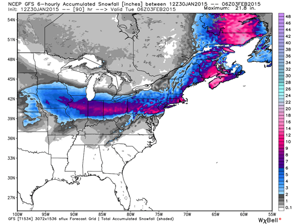
[12Z GFS total snowfall map for the upcoming storm; courtesy Weather Bell Analytics]

Discussion

Copious amounts of moisture will head out of the southwestern states on Saturday and into the central Plains and then continue right towards the Mid-Atlantic region later this weekend. Significant snow is occurring today in the southwest US (e.g., New Mexico) and it’ll move into the region between Kansas and Indiana by tomorrow afternoon. By Sunday, this moisture will begin streaming into the Mid-Atlantic region with cold air place and snow is likely break out during the late afternoon or early evening hours. The low pressure system associated with this moisture is likely to move in a general west-to-east fashion across West Virginia into Virginia and then to the Delmarva Peninsula coastal region by Monday morning. It is unlikely that this track shifts any farther to the north from here given the developing blocking pattern in the upper atmosphere over eastern Canada and southern Greenland. In fact, there is the chance this storm track shifts slightly to the south by the time the event rolls around which would likely increase the chances for more snow south of the PA/MD border. With the current projected storm track, warmer air in lower levels of the atmosphere may cause a changeover from snow to sleet and freezing rain, and perhaps even to plain rain in the region south of the PA/MD border from near DC to southern New Jersey. This would reduce potential snowfall accumulations significantly in that area; however, there still could be up to a few inches at the onset of the storm and then perhaps some more at the end sometime later Monday.

North of the PA/MD border; however, where much of the precipitation is likely to be in the form of snow along with sleet mixed at times, there can be substantial snowfall accumulation amounts. Given the current projected storm track, a general 6-12 inch snowfall is possible from Chicago to Pittsburgh to Philly to NYC and then to Boston. There are still a couple of days to go; however, and a slight shift in the storm track would make a huge difference. No matter what happens with this early week storm regarding snowfall, bitter cold air is likely to follow for much of next week. In fact, there could be record-challenging cold in the Northeast US on Tuesday, Friday and Saturday mornings with one Arctic blast immediately following the storm and then another one late next week. The map above shows the 12Z GFS predicted snowfall amounts for this upcoming storm with a big drop off south of the PA/MD border and the surface forecast map (below) is for Monday morning and depicts the position of the surface low right near the DC metro region (both maps courtesy Weather Bell Analyltics at weatherbell.com].

Stay tuned, and only 20 days until pitchers and catchers report.

gfs_fcst_map_mon_am [12Z GFS surface forecast map for Monday morning; courtesy Weather Bell Analytics]

7:00 AM | **Powerful winds develop later today and continue tonight with possible 50 mph wind gusts...significant snow threat Sunday afternoon into Monday, but mixing is still on the table**

Paul Dorian

6-Day Forecast

Today

Dramatically increasing winds today with gusts to 50 mph late in the day, partly sunny skies, cold, snow showers possible, temperatures have already peaked for the day in the middle 30's and should drop during the afternoon, wind chills lowering during the afternoon hours

Tonight

Still windy and becoming frigid with brutally cold wind chill, mostly clear skies, lows by morning in the low-to-mid teens

Saturday

Mostly sunny, windy, cold, upper 20’s for highs, much lower wind chills

Saturday Night

Partly cloudy, much calmer winds, very cold, low 20’s

Sunday

The potential exists for a significant snow event Sunday afternoon into Monday…becoming cloudy, cold, snow likely later in the day and at night, there is the chance for somw mixing with rain or sleet, mid 30’s

Monday

Snow possible early; otherwise, mostly cloudy, windy, cold, mid-to-upper 20’s; brutal cold at night

Tuesday

Mostly sunny, very cold, mid 20’s

Wednesday

Partly sunny, not as cold, mid 30's

Discussion

The big story today will be the increasing winds which could gust to 50 mph by the end of the day and into tonight. The clipper system responsible for yesterday's sleet/rain mix around here will intensify rapidly today on its way to northern New England where more significant snow can fall. This storm intensification will dramatically stiffen the pressure gradient leading to strengthening winds here later today and tonight primarily out of the northwest. Arctic air will plunge into the region today riding in on those strong NW winds with snow showers possible and it'll be frigid tonight and Saturday with brutally cold wind chill values.

On Saturday, copious amounts of moisture will head out of the southwestern states and into the central Plains and then continue right towards the Mid-Atlantic region later this weekend. Significant snow is occurring today in the southwest US (e.g., New Mexico) and it’ll move into the region between Kansas and Indiana on Saturday. By Sunday, this moisture will begin streaming into the Mid-Atlantic region and snow is likely break out around here during the afternoon hours. Quite cold air will be in place in the Mid-Atlantic region with anchoring high pressure systems situated to the north and northwest. This storm has the potential to produce several inches of snow in the entire I-95 corridor region from Sunday afternoon into Monday, but that is still a couple days away and – as we experienced earlier this week – a slight shift in the storm track can have significant impact on the outcome. The storm may push just far enough to the north late this weekend to allow for the possibility of mixing in southern sections of the Mid-Atlantic (e.g. DC metro region) and this would have a big impact on potential snow accumulations. No matter what happens with this early week storm, bitter cold air is likely to follow for much of next week.

Video

httpv://youtu.be/nc8M87WGLxA

12:00 PM | **Clipper/front impacts the region later today, early tonight...significant snow threat later Sunday into Monday**

Paul Dorian

ecmwf_apcp_f96_us[12Z Euro 96-hour forecast for Monday morning; map courtesy WSI]

Discussion

Overview There are two systems that are likely to spread wintry precipitation into the I-95 corridor over the next few days. The first system will be limited in moisture; however, it still can produce some slippery spots later today and early tonight. The second system will have lots of moisture to work with, lots of cold air in place as it arrives, and it has the potential to produce several inches of snow around here from late Sunday into Monday.

Late today, tonight – the clipper system and its associated cold front The first system is a clipper type of low pressure that is currently located over the eastern Great Lakes and it will drag a cold front across the region in the overnight hours. This system will not produce much precipitation in the I-95 corridor, but there can be enough for some slippery spots given the cold ground conditions.

In DC, the timing is not good as the precipitation is likely to arrive by 3PM or so and primarily be in the form of sleet although freezing rain and snow can be mixed in. This evening’s commute in the DC metro region is likely to see slippery spots on the roadways associated with this upcoming wintry mix. North of the PA/MD border, precipitation should primarily be in the form of snow; however, even that far north, there can be some sleet mixed in at times. The snow or snow/sleet mix should arrive in Philly by 5pm or so, and then in NYC around 8pm or so. The latter stages of the evening commute in Philly can certainly be affected by the weather, but the NYC rush hour should expire before precipitation arrives up there. Snow accumulations in Philly and NYC can end up in the “coating to an inch or two” range by later tonight.

This clipper system will then intensify rapidly late tonight and it will have a much bigger impact on northern New England. Areas north of the Massachusetts Turnpike (e.g., New Hampshire and Maine) will likely get hit by several inches of accumulating snow and strong winds – something they really don’t need. Winds will get quite strong around here tomorrow and tomorrow night resulting in very low wind chill values and the actual air temperatures could drop into the single digits in some areas late tomorrow night. Saturday stays on the frigid side around here with highs confined to 20’s at best.

Late Sunday into Monday - a significant snow threat for the I-95 corridor Over the weekend, copious amounts of moisture will head out of the southwestern states and into the central Plains and then right towards the Mid-Atlantic region. Significant snow is likely first in New Mexico (tonight, Friday) and then from Kansas to Illinois on Saturday. By Sunday, this moisture will begin streaming into the Mid-Atlantic region and snow is likely to be the result. Quite cold air will be in place in the Mid-Atlantic with anchoring high pressure systems situated to the north and northwest. This storm has the potential to produce several inches of snow late Sunday into Monday in the entire I-95 corridor region from DC-to-Philly-to-NYC and also throughout much of the region between I-80 and I-70. It is still a few days away; however, and - as we experienced earlier this week - a slight shift in the pattern can have significant impact on the outcome. No matter what happens with this early week storm, bitter cold air is likely to follow for much of next week.

Video

httpv://youtu.be/z3EdU4CVB0E

7:00 AM | Clipper low and an Arctic front affect the region later today into tonight...more important system possible later Sunday into Monday

Paul Dorian

6-Day Forecast

Today

Becoming mainly cloudy, breezy, cold, chance for a wintry mix of sleet and rain late in the day, highs in the mid-to-upper 30’s

Tonight

A light wintry mix of sleet and rain early, cold, lows by morning in the upper 20’s

Friday

Partly sunny, very windy, cold, chance for a few snow showers, low 30’s

Friday Night

Very cold with mostly clear skies, blustery, low-to-mid teens for lows

Saturday

Mostly sunny, breezy, very cold, mid-to-upper 20’s

Sunday

Mostly cloudy, cold, chance for some snow late, possibly mixed with sleet and/or rain, mid 30’s

Monday

Snow or mixed precipitation possible early, windy, cold, temperatures hold in the 20's

Tuesday

Mostly sunny, very cold, mid 20’s

Discussion

A clipper low pressure system with Arctic air behind it will drop southeastward today across the eastern Great Lakes and produce a wintry mix of sleet and rain later today into early Friday and this could cause slippery spots on the roadways. Strong winds on Friday behind the system will usher in a very cold air mass and temperatures should plunge to the lower teens late tomorrow night. After a very cold Saturday, clouds will increase on Sunday as an area of low pressure approaches from the southwest. As a result, snow is possible later Sunday into Monday, possibly mixed with rain or sleet at times, but there is the potential for several inches of snow accumulation. Brutal cold air will affect the region during much of next week.

Video

httpv://youtu.be/z3EdU4CVB0E

7:00 AM | Clipper low moves to our north tomorrow night...another system arrives later Sunday/Monday

Paul Dorian

6-Day Forecast

Today

Mostly sunny, breezy, cold, highs in the low 30’s

Tonight

Mostly clear, very cold, lows by morning in the upper teens

Thursday

Becoming mainly cloudy, cold, chance for snow and/or rain late, mid 30’s

Thursday Night

Occasional snow and/or rain likely, cold, upper 20’s

Friday

Partly sunny, windy, cold, maybe a snow shower, low 30’s, bitter cold at night with lows not far from 10 degrees

Saturday

Partly sunny, very cold, mid-to-upper 20’s

Sunday

Mostly cloudy, quite cold, chance for snow, sleet, freezing rain or plain rain, mid 30’s

Monday

A wintry mix possible early, windy, cold, low 30's

Discussion

The powerful nor’easter is gone and high pressure will take control today generating plenty of sunshine in the Mid-Atlantic region. A clipper low pressure system will drop southeastward on Thursday through the Great Lakes region and should produce a nuisance event around here on late tomorrow into early Friday with snow and/or rain likely. Very cold air will follow to close out the work week with low temperatures on Friday night likely plunging to near 10 degrees. Another system will threaten the region with snow or a wintry mix late Sunday into Monday and that system will have lots of moisture to work with. Given the very cold air mass in place ahead of it on Friday night and Saturday, this system could become a real mess around here. More brutal cold air will follow the "Super Bowl system" for Monday night and Tuesday of next week.

Some notes about the northeastern blizzard: -biggest snowstorm ever for Worcester, MA (34.5", records back to 1905) -biggest January snowstorm ever for Boston, MA (24.6") and 6th biggest ever -4th biggest snowstorm ever in Portland, ME (23.8") -3 feet was officially recorded in Hudson, Auburn, Lunenburg (all in Massachusetts)