Contact Us

Use the form on the right to contact us.

You can edit the text in this area, and change where the contact form on the right submits to, by entering edit mode using the modes on the bottom right. 


123 Street Avenue, City Town, 99999

(123) 555-6789

email@address.com


You can set your address, phone number, email and site description in the settings tab.
Link to read me page with more information.

backlit-stratus-clouds-2013-04-05.jpg

Blog

Weather forecasting and analysis, space and historic events, climate information

Filtering by Category: DC

7:00 AM | *An unsettled and steamy week with heavy rain and localized flooding possible*

Paul Dorian

6-Day DC Forecast

Today

Partly sunny, hot, more humid, chance for showers and thunderstorms late in the day, some of the rain can be heavy at times, highs in the lower 90's

Tonight

Mostly cloudy, mild, muggy, chance for showers and thunderstorms and some of the rain can be heavy at times, lows in the lower 70’s

Tuesday

Partly sunny, hot, humid, chance for showers and thunderstorms and some of the rain can be heavy at times, low 90's

Tuesday Night

Chance for showers and thunderstorms; otherwise, mostly cloudy, mild, muggy, low 70’s

Wednesday

Partly sunny, very warm, showers and thunderstorms likely to return at night, upper 80's

Thursday

Mostly cloudy, very warm, humid, chance for showers and thunderstorms and some of the rain can be heavy at times, near 90 degrees

Friday

Partly sunny, very warm, humid, chance for showers and thunderstorms late, near 90 degrees

Saturday

Partly sunny, very warm, humid, chance for showers and thunderstorms, near 90 degrees

Discussion

Much of this week will be unsettled as multiple disturbances push along a frontal boundary zone that will hang around the Mid-Atlantic region. As a result, numerous rounds of showers and thunderstorms are possible during the week with heavy rain and localized flooding possible in any given location. It'll be steamy as well this week with most days at or above the 90 degree mark for high temperatures along with rather uncomfortable humidity levels.

3:00 PM | Isolated-to-scattered strong thunderstorms firing up

Paul Dorian

ne3comp
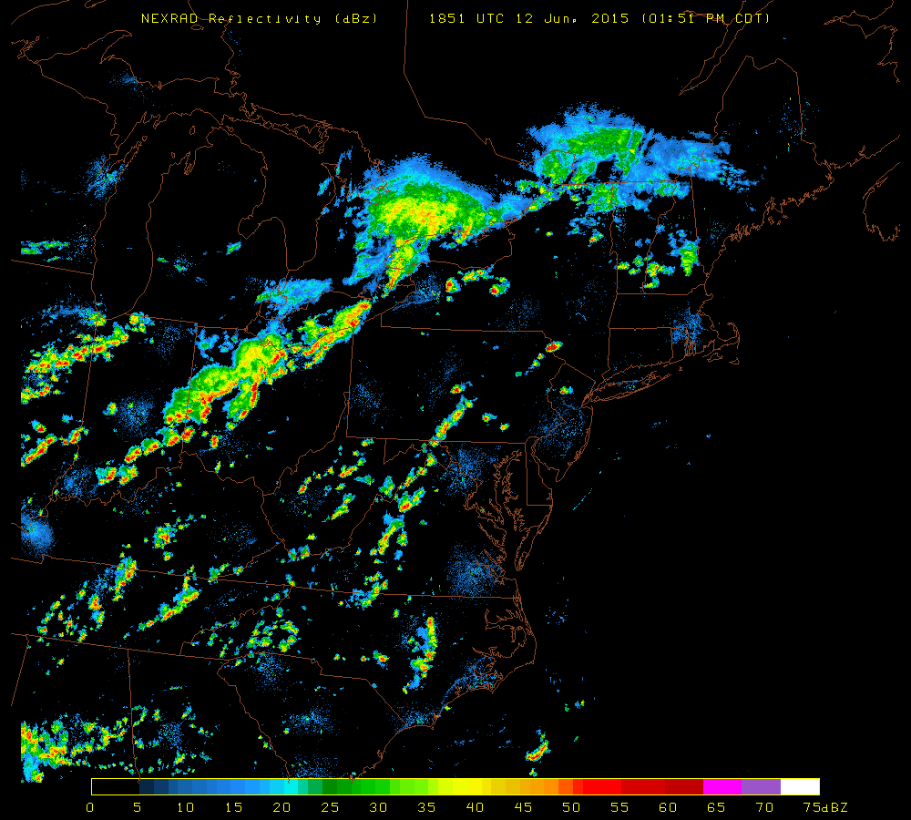
[Latest NEXRAD radar image; courtesy University of Wisconsin]

Discussion

Strong thunderstorms have fired up in higher elevation regions from central Pennsylvania to eastern West Virginia and the environment is unstable enough around here for some of the strong storms to make it to the immediate I-95 corridor during the next few hours (4-9pm). Temperatures have soared into the 90’s across the region and humidity levels are quite high at uncomfortable levels. The combination of the heat and humidity along with some upper-level energy will support some of this storm activity as it treks eastward during the latter part of the afternoon and early evening hours. While the storms will be only isolated-to-scattered in terms of areal coverage, any area that does get hit could experience strong wind gusts, hail and brief downpours.

7:00 AM | Continued hot and humid for today and Saturday; scattered storms will form later today and some can get strong

Paul Dorian

6-Day DC Forecast

Today

Mainly sunny, hot, humid, chance for an afternoon shower or thunderstorm, highs in the low-to-mid 90’s

Tonight

Chance for an early evening shower or thunderstorm; otherwise, partly cloudy skies, mild, muggy, lows in the lower 70’s

Saturday

Partly sunny, still pretty hot, humid, chance for a shower or thunderstorm, near 90 degrees

Saturday Night

Chance for an early shower or thunderstorm; otherwise, mostly cloudy, mild, near 70 degrees

Sunday

Partly sunny, warm, humid, late day or nighttime showers and thunderstorms, some can be on the strong side, upper 80's

Monday

Partly sunny, very warm, more humid again, chance for more showers and thunderstorms, near 90 degrees

Tuesday

Partly sunny, quite warm, humid, chance for showers and thunderstorms, near 90 degrees

Wednesday

Partly sunny, quite warm, humid, chance for showers and thunderstorms, mid-to-upper 80’s

Discussion

Hot and humid weather conditions will continue today with temperatures soaring into the 90's and Saturday will remain very warm and muggy, but relief is coming for Sunday in terms of heat and humidity following the passage of a cool frontal system. As far as precipitation is concerned, a weak frontal system will likely generate isolated-to-scattered showers and thunderstorms later today and early tonight and, while many spots will remain rain-free, locations that do get hit could experience gusty winds, hail and brief downpours. A cool frontal system will generate scattered showers and thunderstorms on Saturday and Saturday night. Beyond that, despite the frontal passage by Sunday, showers and strong thunderstorms cannot be ruled out as we close out the weekend, and the threat for shower and thunderstorm activity will continue during each day of the new work week.

Video

httpv://youtu.be/Lkhb7xsIfdQ

7:00 AM | Humidity rises today as temperatures soar to the lower 90's

Paul Dorian

6-Day DC Forecast

Today

Mainly sunny, hot, more humid, slight chance for an afternoon shower or thunderstorm, highs in the lower 90’s

Tonight

Slight chance for an early shower or thunderstorm; otherwise, partly cloudy skies, mild, muggy, lows near 70 degrees

Friday

Partly sunny, hot, humid, chance for an afternoon shower or thunderstorm, low 90’s

Friday Night

Chance for an early shower or thunderstorm; otherwise, partly cloudy skies, mild, muggy, low 70’s

Saturday

Partly sunny, still pretty hot, humid, chance for a shower or thunderstorm, near 90 degrees

Sunday

Partly sunny, not as warm and less humid, mid-to-upper 80’s

Monday

Mostly cloudy, quite warm, more humid, chance for showers and thunderstorms, mid-to-upper 80’s

Tuesday

Partly sunny, very warm, muggy, chance for showers and thunderstorms, near 90 degrees

Discussion

Humidity values were at comfortable levels on Wednesday, but it’ll turn more uncomfortable today as temperatures soar to the lower 90's and overall humidity levels climb. A weak cool front will set off isolated showers and thunderstorms in the Mid-Atlantic region later today and early tonight, but most spots south of the PA/MD border will remain rain-free. A warm frontal system will push through the region on Friday and this may generate a few scattered showers and thunderstorms to go along with continued very warm and humid conditions. Yet another front (cool) will approach on Saturday and this too will generate a few scattered showers and thunderstorms to go along with very warm and humid weather conditions. Once that front clears the east coast on Saturday night, it’ll set the stage for a nicer day on Sunday with lower humidity and more comfortable temperatures.

12:20 PM | Redder-than-normal sunset possible tonight due to Canadian wildfire smoke

Paul Dorian

goes_vis.gif

goes_vis[GOES visible satellite image; courtesy NOAA, Penn State eWall]

Discussion

A milky haze can be seen in the latest GOES visible satellite image (above) across West Virginia, Virginia and the Delmarva Peninsula and all of this is the result of wildfire activity across southern Canada. Upper levels winds have pushed the smoke from southern Canada into the Mid-Atlantic region over the past 24 hours or so and it very well could contribute to a redder-than-normal sunset in much of the Mid-Atlantic region; especially, across the DC metro region. The wildfire smoke can also be seen in a recent NASA MODIS satellite image (below) and the circled area shows the active wildfire locations (red dots) that have contributed to our current milky skies and possible spectacular sunset.

image-download 
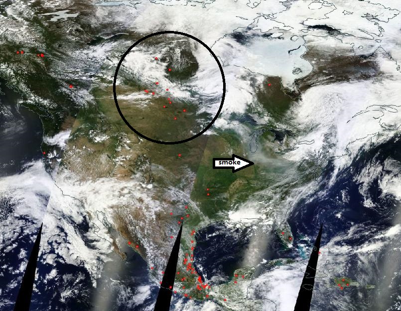
[NASA MODIS US visible satellite image; courtesy NASA]

7:00 AM | 90's on Thursday and Friday after a nice day at the mid-week point

Paul Dorian

6-Day DC Forecast

Today

Mostly sunny, quite warm, comfortable humidity levels, highs in the mid-to-upper 80’s

Tonight

Mostly clear, mild, lows in the middle 60’s

Thursday

Mainly sunny, hot, more humid, slight chance for an afternoon shower or thunderstorm, low 90’s

Thursday Night

Slight chance for an early shower or thunderstorm; otherwise, partly cloudy skies, mild, muggy, near 70 degrees

Friday

Partly sunny, hot, humid, a couple of afternoon showers and thunderstorms are possible, low 90’s

Saturday

Partly sunny, still pretty hot, humid, chance for showers and thunderstorms late in the day or at night, near 90 degrees

Sunday

Partly sunny, not as warm, lower humidity levels, chance for showers and thunderstorms, mid 80’s

Monday

Partly sunny, warm, more humid again, chance for showers and thunderstorms, mid-to-upper 80’s

Discussion

High pressure builds into the region today providing us with very warm, but rather comfortable humidity levels and plenty of sunshine. A weak cool front will approach the region later tomorrow raising the chances again for a shower or thunderstorm on what will be a rather hot day with highs in the lower 90's and an increase in humidity. Hot weather continues on Friday and a warm frontal system will likely generate a few PM showers and thunderstorms in the Mid-Atlantic region. Yet another frontal system (cool) will approach us late Saturday bringing with it a renewed shot for showers and thunderstorms. Ahead of that next cool front, it'll stay very warm on Saturday with rather uncomfortable humidity levels, but the passage of this front should usher in more comfortable air for Sunday with reduced temperatures and humidity values.

7:00 AM | Scattered morning showers, but improvement this afternoon...hot on Thursday and Friday

Paul Dorian

6-Day DC Forecast

Today

Clouds this morning with scattered showers, clearing skies this afternoon, quite warm, highs in the mid 80’s

Tonight

Mostly clear, mild, lows in the low-to-mid 60’s

Wednesday

Mainly sunny, quite warm, mid-to-upper 80’s

Wednesday Night

Partly cloudy, mild, mid 60’s

Thursday

Mainly sunny, hot, low-to-mid 90's; chance for a shower or thunderstorm late in the day or at night

Friday

Mainly sunny, hot, low-to-mid 90’s; chance for a shower or thunderstorm at night

Saturday

Partly sunny, still pretty hot, chance for showers and thunderstorms, near 90 degrees

Sunday

Partly sunny, not as hot, chance for showers and thunderstorms, mid 80’s

Discussion

One cool front set off widespread showers and thunderstorms in the I-95 corridor late yesterday and last night and a secondary front is bringing scattered showers to the region this morning; however, clearing should take place during the afternoon hours. Once this second front clears the east coast later tonight, the Mid-Atlantic region should enjoy mainly ran-free weather during the second half of the week - though a shower or thunderstorm cannot be ruled out - an it'll turn quite hot with highs in the low-to-mid 90's on a couple of occasions.

2:50 PM | Strong-to-severe thunderstorm threat for tonight

Paul Dorian

ne3comp
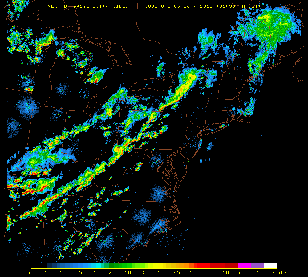
[NEXRAD radar image at 2:33 PM; courtesy University of Wisconsin]

Discussion

The combination of an approaching cold front, building heat and humidity, and an upper-level wave of energy is sparking the formation of strong-to-severe thunderstorms in much of western portions of the Mid-Atlantic region. Latest radar (above) shows an impressive line of thunderstorms from central Pennsylvania to West Virginia in a pre-frontal trough of low pressure. Skies have partially cleared along the I-95 corridor from the morning low cloud deck and this has allowed for afternoon de-stabilization of the atmosphere with increasing low-level heating. The National Weather Service has not put out any watches or warnings for the immediate I-95 corridor; however, they have issued “tornado watches” for areas just to the west of the big cities. NWS “watches/warnings” are likely to be issued later today for the I-95 corridor from DC-to-Philly-to-NYC. Any thunderstorm this evening can contain damaging wind gusts, brief downpours, hail and perhaps even an isolated tornado with the expected timetable of ~6pm to midnight.

7:00 AM | Showers and thunderstorms later today and early tonight...some of the storms will be on the strong-to-severe side

Paul Dorian

6-Day DC Forecast

Today

Partly sunny, breezy, warm, chance for showers and thunderstorms later this afternoon, highs in the mid-to-upper 80’s

Tonight

Showers and thunderstorms likely, some of the thunderstorms will be on the strong-to-severe side with heavy rainfall and gusty winds, mild, lows in the upper 60’s

Tuesday

Partly sunny, warm, still the chance for a shower or thunderstorm, mid 80’s

Tuesday Night

Partly cloudy, mild, low 60’s

Wednesday

Mainly sunny, warm, mid-to-upper 80’s

Thursday

Mainly sunny, hot, low 90's

Friday

Mainly sunny, hot, low 90's

Saturday

Partly sunny, quite warm, chance for showers and thunderstorms, near 90 degrees

Discussion

A strong cool front will approach the region later today and tonight bringing with it a fresh round of showers and thunderstorms to the I-95 corridor. Some of the thunderstorms that form later today in the Mid-Atlantic region will be on the strong-to-severe side with heavy rainfall, gusty winds and possible hail. Improvement will follow the frontal passage by mid-week, but temperatures will reach very warm levels during the second half of the week with highs likely surpassing the 90 degree mark.

Video

httpv://youtu.be/QbVhZcnUoys

7:00 AM | Weekend looking pretty decent after yet another cloudy, damp and cool day

Paul Dorian

6-Day DC Forecast

Today

Mostly cloudy although there can be some brightening at times, still on the cool side with a spotty shower or two, highs in the low 70's

Tonight

Mostly cloudy, cool, slight chance for a shower, lows not far from 60 degrees

Saturday

Partly sunny, warmer, chance for a shower or thunderstorm, near 80 degrees

Saturday Night

Partly cloudy, mild, maybe a shower or thunderstorm, near 60 degrees

Sunday

Partly-to-mostly sunny, comfortable, upper 70’s

Monday

Partly sunny skies, quite warm, a fresh round of showers and thunderstorm likely late, near 85 degrees

Tuesday

Mainly cloudy skies, still quite warm, chance for a shower or thunderstorm, mid 80’s

Wednesday

Mainly sunny skies, warm, mid 80’s

Discussion

All in all, the weekend is looking pretty decent…a cold front will cross the region early Saturday and it could set off a spotty shower or thunderstorm in the I-95 corridor on Saturday, but much of the day will be rain-free and Sunday looks especially nice with sunshine, comfortable temperatures and humidity levels. Another cold front will approach the region later Monday and it is likely to bring a fresh round of showers and thunderstorms to the region along with warmer conditions.

Video

httpv://youtu.be/kPWjYxq-iw0