12:30 PM | **Interesting features on today’s visible satellite image and an update on the sneaky accumulating snow threat for tomorrow**
Paul Dorian
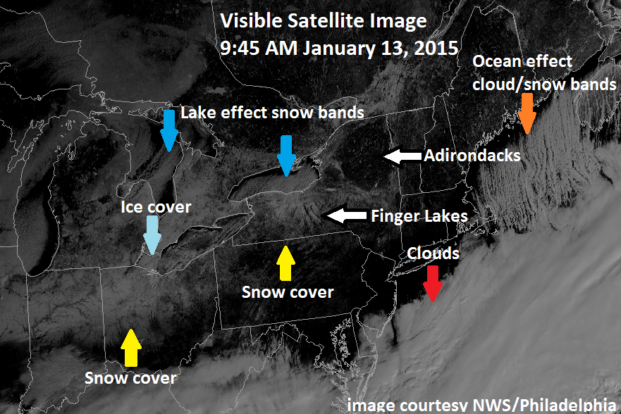
 [Morning visible satellite image with numerous interesting features; courtesy National Weather Service/Philadelphia; NOAA]
Discussion
Visible satellite image and some interesting features Satellite images are extremely valuable in the world of weather forecasting and this morning’s GOES visible image has several interesting features in the Great Lakes region, Ohio Valley and Northeast US. First, clear skies exist in the I-95 corridor region from DC-to-Philly-to-NYC and these cloud-free conditions should last into the early part of tonight allowing for the possibility of viewing Comet Lovejoy (see posting at http://vencoreweather.com/2015/01/13/1050-am-an-update-on-comet-lovejoy-now-in-its-best-two-weeks/). However, thick clouds can be seen on the satellite image just to the south and east of DC and they will advance northward later tonight associated with an area of moisture that may produce some snow around here on Wednesday (see below). Elsewhere, snow cover can be seen across northern Indiana and northern Ohio as well as in New York State, and geographical features like the Finger Lakes and Adirondacks Mountains become quite noticeable with clear skies and surrounding snow cover.
In addition, a northerly wind is generating “lake-effect” snow bands that are dropping southward from Lake Ontario into western New York State and the same atmospheric pattern is generating cloud and snow bands just downwind of Maine (for more on the “lake-effect” snow phenomenon check out video #20 on our Meteo 101 page: http://vencoreweather.com/meteorology-101/). Finally, ice cover is starting to expand quite rapidly in the Great Lakes and given the current cloud-free skies, some of this is visible on today's visible satellite image over western Lake Erie (the shallowest of the Great Lakes which often freezes early). Let me add that the best way to confirm that these surface features are real (ice cover, snow cover, etc.) is to look at a loop of visible satellite images which can be done at the Penn State eWall web site: http://mp1.met.psu.edu/~fxg1/SAT_NE/anim8vis.html).
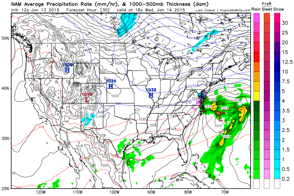
Sneaky snow threat for Wednesday in parts of the Mid-Atlantic region Accumulations of snow are on the table for parts of the Mid-Atlantic region on Wednesday; especially, in the region from the DC metro region-to-southern New Jersey and cutting across the Delmarva Peninsula where a coating to an inch or two can fall. Some light snow accumulations can even occur as far north and east as the Philly and NYC metro regions, but higher chances do exist just to the south and east of those areas. The combination of weak upper level energy, increasing low-level east-to-northeast flow off the Atlantic Ocean, and an area of moisture currently sitting over the Carolinas will likely generate some snow accumulations in parts of the Mid-Atlantic region late tonight and Wednesday - likely in time to have an impact on the DC morning commute. Sleet could mix in at times tomorrow to the south and east of DC and especially near coastal sections of New Jersey and the Delmarva Peninsula, but given the influx today of fresh cold, dry Arctic air, primarily snow should fall in and around DC (and in Philly and NYC if it makes it that far). Stay tuned on this as it is a tricky forecast.
 [12Z NAM forecast map for mid-day Wednesday (blue=snow, purple=sleet); courtesy "tropicaltidbits.com"]