12:00 PM | **Stormy and cold pattern developing for the next few weeks with multiple Arctic air outbreaks and numerous storm threats**
Paul Dorian
Discussion
Overview The pattern setting up for the next few weeks looks quite active and cold with multiple Arctic air outbreaks and storm threats. The southern branch of the jet stream will become more active and this will push Pacific Ocean moisture into the southern US which can move across the nation into the eastern US. After today’s precipitation event, there will be a couple of tranquil days in the Mid-Atlantic region with moderately cold conditions, but then the next clipper type of low pressure system and its associated Arctic blast will be ready to pounce on the area by Thursday night. Before that late week Arctic air mass even has a chance to modify, another clipper system and associated Arctic invasion will be plunging towards the Mid-Atlantic region by Saturday night. Beyond that, it appears yet another storm threat is likely around Tuesday or so of next week and this one will feature lots of moisture from the southern states. That storm next week could ultimately turn into a significant winter storm for the Mid-Atlantic region, but the storm track is, of course, still uncertain this far in advance.
This afternoon and tonight Colder air continues to trickle into the I-95 corridor as our Monday progresses and this will lead to mainly frozen precipitation in the Philly and NYC metro regions for the rest of this event. In Philly, the intermittent precipitation should fall as sleet and/or snow this afternoon with a change to all snow likely tonight. Accumulations by later tonight can be on the order of a coating to an inch with slick spots on untreated surfaces. In the NYC metro region, any wintry mix early this afternoon is likely to become all snow by later this afternoon and accumulations of snow and ice by later tonight should be on the order of 1-2 inches with slick spots on untreated surfaces. In DC, any plain rain that falls this afternoon is likely to turn into a wintry mix of freezing rain and sleet tonight, perhaps even ending briefly as all snow late tonight. Slick spots are likely on untreated surfaces in the overnight hours and there can be a coating of snow and/or ice.
Thursday night clipper and powerful Arctic blast By late Thursday, the next clipper and powerful Arctic front will blast into the Mid-Atlantic region with strengthening winds and numerous snow showers which could even include a heavier snow squall and/or a period of steadier snow. The upper-level pattern at 500 millibars for Thursday night is quite impressive with a deep trough of low pressure situated right on top of the Mid-Atlantic region (below). This will allow for rapid development of the clipper system once it reaches the warmer waters of the western Atlantic and this could lead to an all-out blizzard for – you guessed it – portions of New England. Temperatures by early Friday will bottom out in the single digits in many suburban locations along the I-95 corridor.
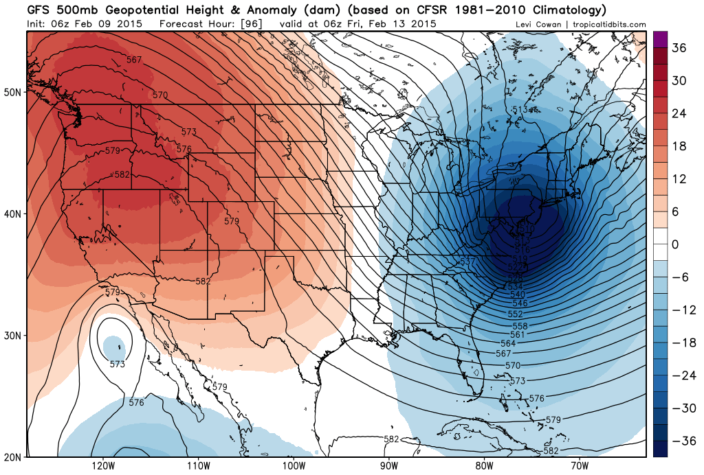
[500 millibar height anomaly forecast map for late Thursday night with deep upper-level trough over the Mid-Atlantic; map courtesy "tropicaltidbits.com"]
Saturday night clipper and powerful Arctic blast By late Saturday, another clipper system will be dropping southeastward from the Great Lakes region into the Mid-Atlantic and this system could generate numerous snow showers in the I-95 corridor late Saturday into early Sunday – perhaps even a period of steadier snow. Once again, a deep upper-level trough will develop in the Mid-Atlantic region (below) in very similar fashion to the Thursday night Arctic blast. As with the Thursday night event, this type of upper-level pattern may allow for rapid development of the clipper system once it reaches the warmer waters of the western Atlantic. This clipper will usher in another brutally cold Arctic air mass for the latter part of the weekend and the early part of next week. In fact, it may turn out that the temperatures early Sunday morning are at the lowest levels seen so far this winter in much of the Northeast US.
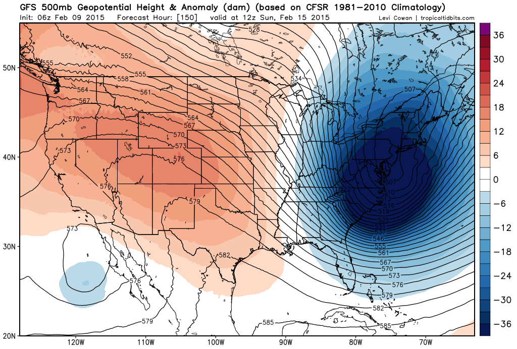
[500 millibar height anomaly forecast map for Sunday morning with deep upper-level trough over the Mid-Atlantic; map courtesy "tropicaltidbits.com"]