1:15 PM | **Another weekend and another accumulating snow and ice threat for the Mid-Atlantic**
Paul Dorian
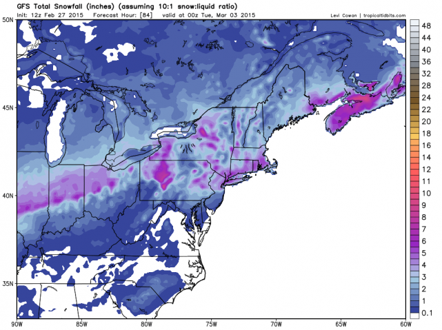 [Total snowfall forecast by the 12Z GFS for the upcoming event; map courtesy "tropicaltidbits.com", NOAA]
Discussion
Weekends have featured very active weather in recent weeks in the I-95 corridor and it looks like this weekend will be no exception. In fact, it appears that there could be a quick “thumping” of accumulating snow later Sunday; especially, in the region between Philly and New York City, and this accumulating snow will be followed by a period of icing. Sound familiar, in many ways this pattern resembles last weekend's situation in which bitter cold weather on Saturday was followed by accumulating snow and then a period of ice on Sunday. In fact, in another similar twist, much of last weekend’s frozen precipitation event took place with an unusual southerly wind direction as high pressure moved off the east coast – usually a recipe for rain around here - and a similar pattern is likely late this weekend. There does appear to be one difference from this upcoming event compared to last weekend and that is the idea that it appears the “thumping” of accumulating snow may take place farther north than last weekend - this time from Philly-to-NYC instead of from DC-to-Philly.
Currently, it looks like precipitation should arrive in the I-95 corridor in the form of snow during the afternoon hours on Sunday with accumulations likely at the onset. The snow will likely change rather quickly to a wintry mix in the DC metro region, but it could hold on as snow for a longer time in the region between Philly and NYC where a few inches can accumulate before a changeover finally takes place and there is a buildup of ice. Much like last weekend, a layer of crusty ice is likely to form on any snow that does accumulate in the I-95 corridor and precipitation should end by early Monday. Temperatures will start off the weekend at very cold levels in the single digits in some suburban locations, but should turn (temporarily) warmer next week before yet another impressive blast of Arctic air arrives on Thursday.