1:00 PM | ***Spring officially begins on Friday and old man winter is saying “not so fast”… accumulating snow in the I-95 corridor***
Paul Dorian
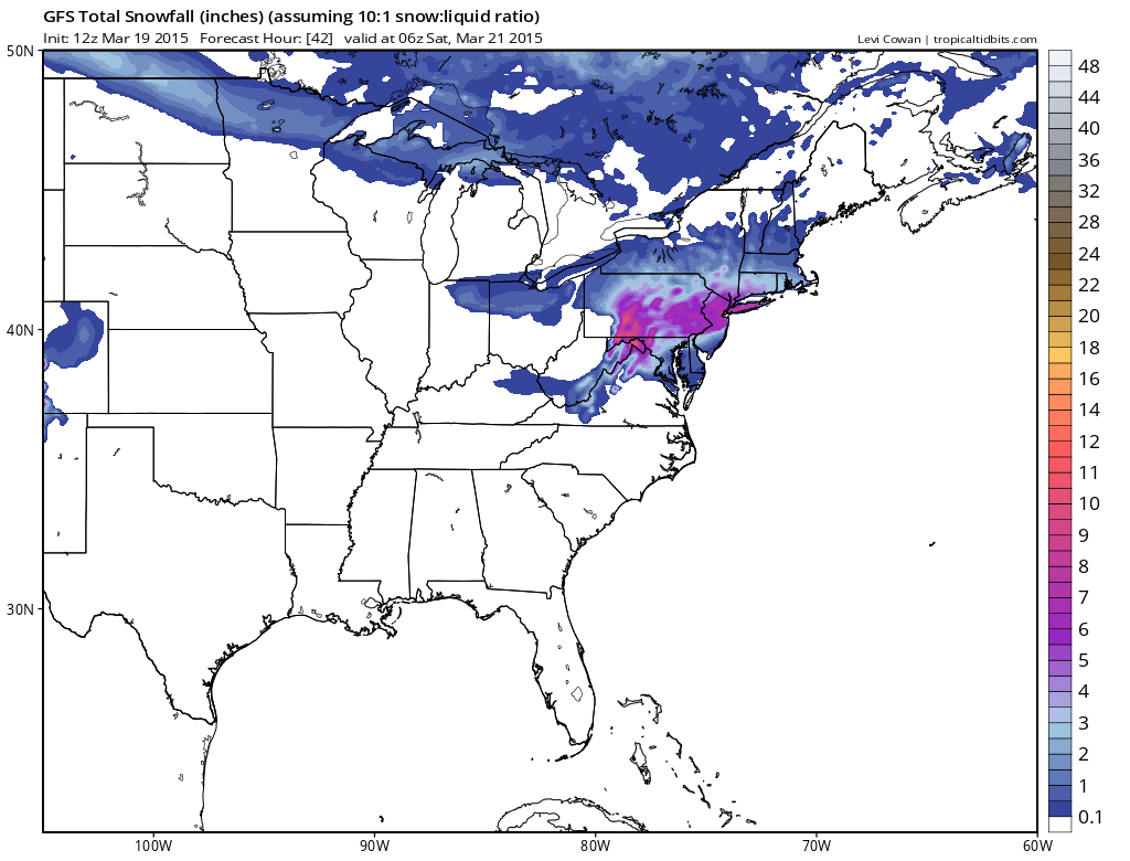
 [12Z GFS snowfall forecast for tomorrow's event; map courtesy "tropicaltidbits.com", NOAA]
Discussion
Astronomical spring begins late tomorrow and old man winter is saying “not so fast”. In our transition back to a winter-like pattern, cold air made a return to the region late Tuesday night and Wednesday and now it appears very likely that accumulating wet snow will make a return on the same day that winter officially comes to an end. Accumulations are likely in all areas along the I-95 corridor and given the time of year and the fact that much of this snowfall will occur during daytime hours, they are quite likely to be highly dependent on elevation and surface type. As a result, expect wide ranges of accumulations across metro regions compared-to-normal on Friday with the highest amounts on grassy surfaces in elevated locations to the north and west of the big cities.
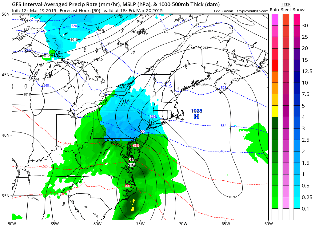
Low pressure will organize early Friday over the Carolinas and then gradually intensify as it moves to the northeast. Precipitation will overspread the I-95 corridor late tonight or early Friday - depending on location - and it should begin as accumulating snow in most areas. In the DC metro region, the snow will mix with and then change over to plain rain later in the morning, but it should hold on as primarily snow in the N and W suburbs of Philly and NYC during much of this upcoming event. The precipitation doesn’t wind down until later tomorrow evening in most areas. Slippery conditions can be expected on the roadways on Friday as the snow will come heavily at times during this event. On a positive note, the storm on Friday could be very photogenic. The wet nature of the snow could cling to tree limbs and surround early spring flowers that have begun to bloom.
 [12Z GFS forecast map for early tomorrow afternoon (blue=snow, green=rain); map courtesy "tropicaltidbits.com", NOAA]
Here are the details for each metro region in the Mid-Atlantic I-95 corridor:
DC region: Snow or rain that will quickly change to snow will develop after midnight and continue into early Friday morning. The snow should then mix with and change to plain rain later in the morning, but not before there are accumulations on the order of a coating to 2 inches in the District and nearby places to its south and east, 2-4 inches in the far N and W suburbs. The highest accumulation amounts should take place on grassy surfaces in elevated locations well to the west and north of the District. The Eastern Shore and Delmarva Peninsula regions should receive an inch or less of snowfall on Friday.
Philly region: Snow should break out right around daybreak and then continue through much of the day. There is a chance that the snow mixes with rain and/or sleet later in the day; especially, in Philly and nearby points to the south and east, but it could remain as all snow well to the north and west of the city. Accumulations expected are on the order of 2-4 inches in and around the immediate Philly metro area, 3-6 inches in the N and W suburbs. The highest accumulation amounts should take place on grassy surfaces in elevated locations well to the north and west of Philly. Southern New Jersey should receive a coating to two inches, central and northern New Jersey should end up in the 3-6 inch range.
NYC region: Snow should begin early Friday and continue through much of the day. There is a chance that the snow mixes with rain and/or sleet later in the day in the NYC metro region and nearby points to the south and east, but it is likely to remain as all snow to the north and west. Accumulations on the order of 3-6 inches are likely with the highest amounts in that range on grassy surfaces in elevated locations to the west and north of NYC.