1:00 PM | **Very significant rainfall with a tropical connection continues to threaten the Mid-Atlantic region for later this week and weekend**
Paul Dorian
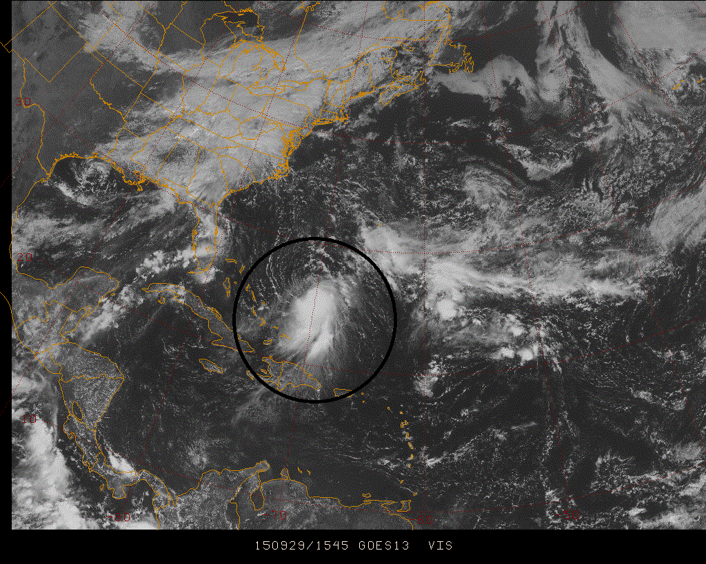
 [Latest visible satellite image of Tropical Storm Joaquin; courtesy Penn State eWall]
Discussion
Quite a complicated weather pattern is unfolding for the Mid-Atlantic region with many players on the field and there are reasons for concern that it could all result in some very significant rainfall later this week and into the weekend. First, a strong cold front will slowly push through the region at mid-week and then will stall along the east coast. This frontal passage will generate some heavy rainfall in the Mid-Atlantic region from later tonight into Wednesday, but that is likely just the opening salvo. Low pressure now situated over the northeastern Gulf of Mexico is then likely to ride up along the stalled out frontal boundary zone generating additional significant rainfall later in the work week. Finally, the combination of a strong upper-level low in the Southeast US late this week and Tropical Storm Joaquin now spinning east of the Bahamas could bring more significant rainfall to the Mid-Atlantic region this weekend.
Tropical Storm Joaquin continues to churn at this hour in the waters east of the Bahamas with sustained winds at 35 knots. The development of the upper-level low later this week over the Southeast US has been consistently forecasted by the computer forecast models with Joaquin “pin wheeling” around it back towards the Mid-Atlantic coastline (“pin wheeling” is known in the meteorological community as the “Fugiwara” effect). Joaquin is currently in an area of wind shear which should suppress intensification somewhat in the near term, but once the shear weakens in 48 hours or so, it could very well strengthen into a hurricane later this week - perhaps even a category 2 or 3. One final note about Joaquin...it may or may not ever make a direct hit on the Mid-Atlantic coastline, but even if it does not, it could still have a major impact by supplying tremendous amounts of tropical moisture into the region.
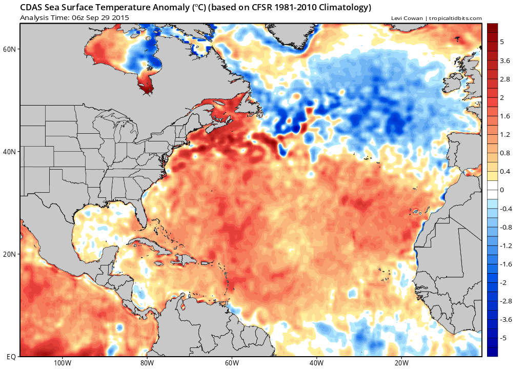
Two other important factors in this unfolding weather event include strong and very slow-moving high pressure which will be situated across southeastern Canada at the end of the week and sea surface temperatures that are above-normal throughout the western Atlantic. Strong and very slow-moving high pressure across southeastern Canada at this time of year often results in tropical mischief along the US east coast. Above-normal sea surface temperatures in the western Atlantic (orange area in the map below) can only help with the intensification prospects for Tropical Storm Joaquin as tropical systems are fueled by warm waters.
 [Sea surface temperature anomalies in the western Atlantic; map courtesy "tropicaltidbits.com"]
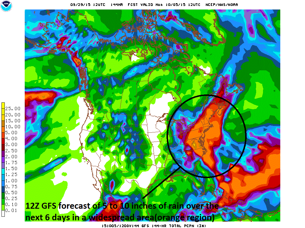
Bottom line…our dry weather pattern of recent weeks will end in a dramatic fashion over the next several days. Very significant rainfall - on the order of 5 to 10 inches according to the latest GFS model run (below) - is on the table for the Mid-Atlantic region in the time period from later today through the upcoming weekend.
 [12Z GFS total rainfall forecast over the next 6 days; courtesy NOAA]
Stay tuned.
Paul Dorian Vencore, Inc.

