
12:40 PM | **“Out to sea” solution for Hurricane Joaquin continues to look viable**
Paul Dorian

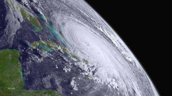 [Satellite image of Hurricane Joaquin from GOES West; courtesy NOAA]
Discussion
Hurricane Joaquin has strengthened slightly in the past few hours with sustained winds now at 125 mph and central pressure at 27.82 inches. Joaquin (image above) has moved slowly to the southwest during the past several hours, but the shortwave ridge causing this motion is weakening and an upper-level trough is developing over the Southeast US. Once this upper-level trough becomes well-established by the weekend, it is likely to begin to influence Joaquin's movement. In fact, the hurricane is likely to turn northward on a track towards the US east coast early in the weekend; however, odds are increasing that Joaquin will then steer away from the coast later in the weekend without ever making landfall.
In the meantime, the combination of a cold front, strong, stationary high pressure to the north, and a "nor'easter-like" low pressure system will produce heavy rainfall and increasingly strong onshore winds in the Mid-Atlantic region from later today into Saturday as the pressure gradient tightens between the high and low. Rainfall amounts of one to three inches are possible in the I-95 corridor between now and early Saturday (higher near DC, lower near NYC) and there can be minor-to-moderate coastal flooding. Winds will be persistent out of the northeast with 30 mph gusts possible at inland locations by the weekend and up to 50 mph at the coast.
Farther south, staggering amounts of rain can fall over the next several days with 1-2 feet possible in parts of the Carolinas and widespread flooding is quite likely in that part of the country. Should Joaquin ever impact the Mid-Atlantic region with a direct hit – and odds are slowly diminishing - it would be in the Sunday-Tuesday time frame. Indeed, odds are probably better right now for some sunshine in the Mid-Atlantic region by the time Sunday afternoon rolls around rather than "stormy" conditions associated with Joaquin; however, stay tuned as this is a slow-moving dangerous hurricane that comes awfully close to the coast for comfort.
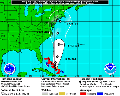 [The latest track of Joaquin from NOAA's Hurricane Center].