7:00 AM | ***Major storm to pound Mid-Atlantic region with heavy rain, strong winds…coastal sections face prospects of 65+ mph wind gusts…power outages a concern***
Paul Dorian
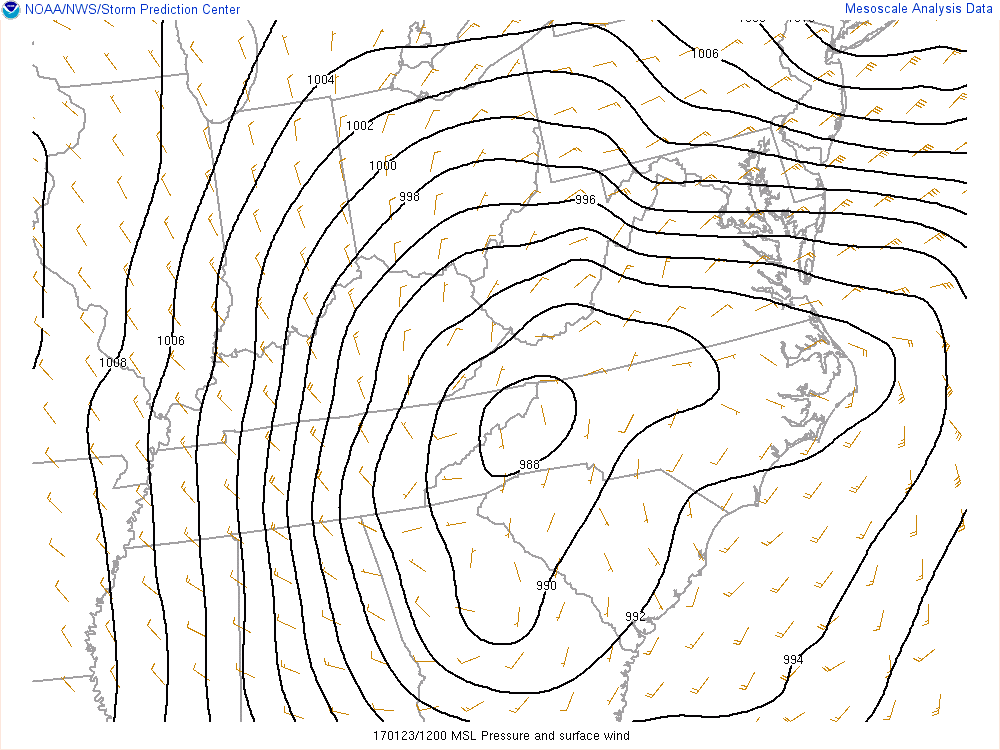
Powerful storm this morning over western Tennessee with tight pressure gradient as represented by black lines; map courtesy NOAA
Overview
Very strong high pressure in southeastern Canada is combining with an intensifying major storm system over the Tennessee Valley to produce a tightening pressure gradient in the Mid-Atlantic region. This will result in potentially damaging wind gusts past 65 mph along coastal sections of the Mid-Atlantic region (i.e., NJ, NY, Delaware) and up to 50 mph across inland locations. In fact, hurricane force winds are possible over the open waters just off of areas like Long Island, NY, NE NJ during the brunt of this storm later today into tonight. In addition to the powerful winds, rain will become more widespread later today and fall heavily at times through the overnight hours. As colder air wraps into the system later today and tonight, the rain can mix with sleet or snow across the northern and western suburbs.
Details
A deep, slow-moving and intensifying upper-level trough is heading right to the Mid-Atlantic coastline and this has helped to spawn a powerful storm in western Tennessee with central pressure at 29.18 inches. This system will maintain that strength for the next several hours as it moves towards the Mid-Atlantic coastal waters. Winds will gust past 50+ mph at inland locations and past 65+ mph at coastal sections and hurricane force gusts are possible just offshore. Power outages are a concern as there can be some downed limbs and power lines; especially, along coastal sections. Rainfall amounts between today and later Tuesday are likely to average 1.0 to 2.0 inches in the DC, Philly, NYC corridor, but higher amounts are possible on a localized basis. Some colder air will wrap into the system later today and tonight causing a changeover of the rain to ice or snow across places in central and NE PA and interior NW NJ. In fact, the rain can mix with ice or snow later today or tonight across the northern and western suburbs as lower atmosphere temperatures drop from early day highs. Coastal flooding is also a concern with the expected long period of onshore winds and the high tide of most concern would be the one coming this evening.
Looking ahead, the overall weather pattern changes noticeably beginning around Thursday to that of one with much more sustained cold thanks, in part, to a major stratospheric warming event that will unfold over the next week or so. This change is likely to bring about colder weather for us going well into the month of February.
Today: Stormy with wind-swept rain, heavy at times, winds gust past 50+ mph inland, past 65+ mph at coastal sections, power outages are a concern; especially, along coastal locations, rain can mix with ice or snow across suburban locations late in the day, temperatures holding in the 40’s this morning and dropping into the 30's later in the day
Tonight: Still very windy with rain, heavy at times, a decent chance the rain mixes with ice and/or snow in the suburban locations as temperatures hold in the 30's
Tuesday: Rain still likely in the morning, windy, cannot rule out a bit of ice and/or snow mixed in with the rain to the N and W of Philly, temperatures climb back into the 40’s late in the day
Tuesday Night: Partial clearing, colder, near freezing
Meteorologist Paul Dorian
Vencore, Inc.
vencoreweather.com

