11:30 AM | *Major hurricane drought in the US could be coming to an end with Harvey*
Paul Dorian

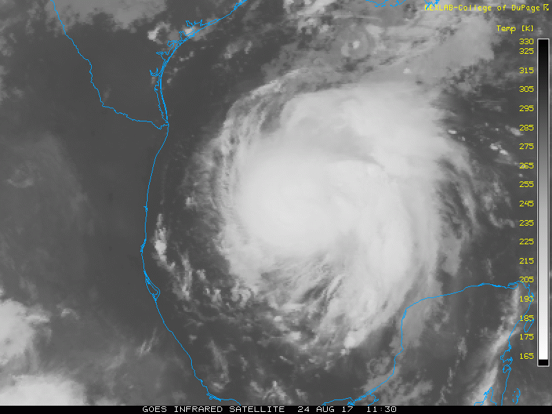
Infrared satellite image loop of the past few hours with rapid intensification of Harvey; image loop courtesy College of DuPage, NOAA/GOES
Overview
Two hurricane streaks could come to an end over the next couple of days. First, Texas has not been hit directly by a hurricane since Hurricane “Ike” struck the state in September 2008 as a category 2 storm. This streak appears quite likely to be coming to an end as Harvey appears to be headed towards hurricane status as it closes in on the southeast Texas coastline. Second, there has not been a major (i.e., category 3 or higher) hurricane strike on the US mainland since 2005 – the longest “drought” of major hurricanes in recorded history since the middle 1800’s. The last major hurricane to hit the US was Wilma in October 2005 (southwestern Florida) - 4322 days ago (info courtesy Philip Klotzbach of Colorado State University). This streak has a chance to come to an end since it is not out of the realm of possibility that Harvey strengthens all the way to category 3 status before making landfall in southeast Texas – perhaps somewhere near Corpus Christi.
Elsewhere, a second tropical system is likely to gain strength over the next few days just off the Florida coastline. If this system indeed reaches tropical storm status – quite a realistic scenario – it would become officially named “Irma”. This tropical system is likely to move slowly northeastward in coming days just off the Southeast US coastline producing heavy rainfall from Florida to North Carolina.

12Z NAM model run supports the idea that Harvey continues to strengthen as it closes in on Texas - perhaps reaching major hurricane status; courtesy tropicaltidbits.com, NOAA/EMC
Harvey could reach major hurricane status
Tropical Storm Harvey has intensified rapidly in the past several hours and now has sustained winds of 65 mph. Its latest movement is to the NNW at only 10 mph. Latest water vapor imagery indicates the storm’s outflow is expanding – indicative of intensification and low wind shear – and this suggests Harvey will soon reach hurricane status. In addition to the low wind shear, Harvey is moving over very warm waters of the western Gulf of Mexico – also favorable for additional strengthening. It is not out of the question that Harvey strengthens all the way to major (i.e., category 3) status over the next day or so as it closes in on the Texas coastline.
In 48 hours or so, Harvey will encounter an environment with weak steering currents sandwiched between a high pressure region over the Gulf of Mexico and another one over the interior western states. As a result, Harvey is likely to slow down to a crawl as it approaches the southeast Texas coastline and perhaps even "forced" to do a loop somewhere over or near the southeastern part of Texas. This expected slow-down is likely to contribute to the piling up of tremendous amounts of rainfall that could ultimately extend from southeastern Texas to southern Louisiana in coming days. Longer term, this tropical storm is likely to make a turn to the northeast and it could eventually result in some rainfall for the Mid-Atlantic region around the end of the month or the early part of September.

"Off-the-scale" rainfall amounts of 2+ feet from Harvey over the next several days according to the 06Z GFS model run; courtesy tropicaltidbits.com, NOAA/EMC
Southeastern US threat extends from Florida to North Carolina
There is a broad trough of low pressure near the southern coast of Florida and there is likely to be little intensification associated with this tropical wave over the next day or two. However, overall environmental conditions are likely to become more favorable for intensification this weekend while the wave sits over the warm waters of the western Atlantic. If this system indeed strengthens into tropical storm status – quite a realistic scenario – it would become officially named “Irma”. By this time, the tropical wave will likely turn northeastward and move rather slowly just off the Southeast US coastline. As a result, significant rainfall is on the table for Florida and all the way along the coastline to the Outer Banks of North Carolina in coming days. Once this system reaches the Outer Banks region of North Carolina, it could push out to sea or come quite close to the Mid-Atlantic coastline – simply too early to tell at this time.
Stay tuned – the next six weeks or so should be quite an active time period in the Atlantic Basin tropical region.
Meteorologist Paul Dorian
Vencore, Inc.
vencoreweather.com