
12:25 PM | *Tropics getting active in the Atlantic Basin*
Paul Dorian

One tropical wave is currently situated over the eastern Caribbean Sea (left circle) and a second tropical wave is out over the eastern Atlantic Ocean (right circle); image courtesy University of Wisconsin/CIMSS, NOAA
Overview
From a climatological point-of-view, it is now the time of year for the Atlantic Basin to start ramping up in terms of tropical activity and indeed, it looks that is happening right on schedule. Typically, the Atlantic Basin ramps up in tropical activity during the month of August, peaks around mid-September, and then gradually winds down during the fall months of October and November. In fact, there are now three tropical waves of interest that will have to be closely monitored over the next several days. One tropical wave is now situated over the Caribbean Sea, a second is located over the eastern part of the tropical Atlantic Ocean, and a third is still far, far away over the continent of Africa.

Atlantic Basin tropical activity tends to ramp up in August and peak in mid-September
Climatology, sea surface temperatures and tropical activity
Sea surface temperatures play a vital role in the formation of tropical storms in the Atlantic Basin and they tend to reach a peak during the month of September. As a result, tropical activity typically ramps up during August and often peaks in mid-September when sea surface temperatures are at their highest. Currently, sea surface temperatures are not only climbing this time of year in some of the breeding ground regions of the Atlantic Basin, they are actually generally above-normal in the Gulf of Mexico, Caribbean Sea and much of the tropical Atlantic Ocean. This large region featuring warmer-than-normal water temperatures should tend to support tropical activity in the next several weeks.

Atlantic Basin tropical activity tends to ramp up in August and peak in September
Tropical wave 1
A large area of clouds and thunderstorms associated with a tropical wave is currently located over the eastern Caribbean Sea and it is moving generally to the west-northwest. It appears that this wave will continue moving towards and perhaps directly over the Yucatan Peninsula region of Mexico and ultimately into the southwestern Gulf of Mexico. Overall environmental conditions are likely to be quite conducive to intensification next week; especially, given the very warm sea surface temperatures in the southwestern Gulf of Mexico. This system could very well end up having a direct impact on northeastern Mexico or the southern part of Texas.

Current map of sea surface temperature anomalies which shows lots of above-normal conditions (orange areas) in the Caribbean Sea, Gulf of Mexico and tropical Atlantic Ocean. This large region of warmer-than-normal water should be supportive of tropical storm formation/intensification. Note the colder-than-normal conditions (blue) currently along the US east coast.; map courtesy tropicaltidbits.com, NOAA
Tropical wave 2
A rather broad area of low pressure associated with a tropical wave is currently spinning over the eastern Atlantic Ocean. Environmental conditions are pretty favorable for this system to become better organized over the next several days as it likely continues on a west-to-northwest course. As a result, tropical storm formation is quite likely within the next 5 days or so. If this system continues to move on its current track, it could become an important player later next week for the Caribbean islands, Bahamas or even the Southeast US.
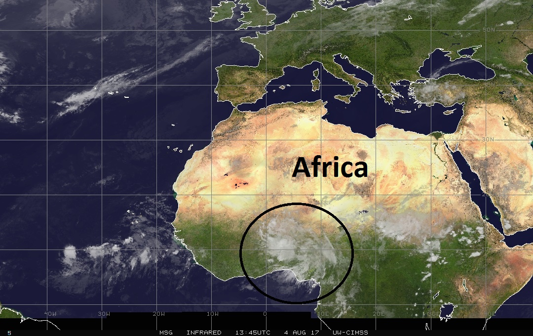
A third and impressive tropical wave can be seen in this infrared satellite image over Africa; image courtesy University of Wisconsin/CIMSS
Tropical wave 3
Perhaps the most impressive tropical wave at this point – at least in terms of satellite imagery – is still over the continent of Africa. It is likely to spill out over the eastern Atlantic over the next several days and then head out on a west-to-northwest track across the tropical Atlantic. If this system holds together – and climatology, sea surface temperatures favors this scenario – then it’ll likely become an important player to watch along the eastern seaboard around the middle of the month.
While it is still way too early to say if any of these three areas of interest will ever have a direct impact on any part of the US, they all bear close monitoring in this increasingly favorable time of year for tropical activity.
Meteorologist Paul Dorian
Vencore, Inc.
vencoreweather.com
Extended video discussion on three tropical waves: