10:00 AM | ***Florida bracing for dangerous Hurricane Irma***
Paul Dorian

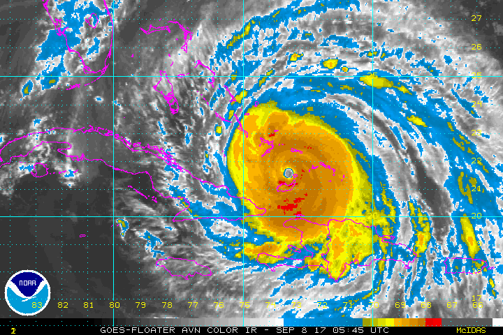
The latest colorized IR satellite imagery loop of Hurricane Irma. It appears to be going through an "eyewall replacement cycle" in which the inner eyewall decays and is replaced by the contracting outer eyewall. Images courtesy NOAA
Irma continues to track west-northwest this morning as a major hurricane - now at category 4 status - and is likely to maintain much of its strength over the next couple of days as it moves over very warm waters. Irma should move to a position quite close to the southern coast of Florida by early Sunday and then it is likely to turn north-to-northwest as deep upper-level troughing digs in over the Northeast US. This likely path will result in virtually the entire state of Florida experiencing hurricane conditions later this weekend and into early Monday as the hurricane crosses from south-to-north roughly over the center of Florida.

12Z Friday GFS forecast of Hurricane Irma for the next 108 hours in 6-hour increments; courtesy tropicaltidbits.com, NOAA/EMC
At landfall, Irma is likely to have category 4 status, but category 5 status is not out of the realm of possibility as there can be some intensification during the final few hours before landfall. By the time Irma reaches the central and northern parts of Florida, it is likely to have weakened some to perhaps category 2 level due to its interaction with land along with increased shear. If there is any impact in the Mid-Atlantic region from what will be the much-weakened remains of Irma, it would likely be in the late Tuesday/early Wednesday time period.

00Z GFS Ensemble run forecast tracks of Irma; map courtesy Weather Bell Analytics, NOAA
Irma has a well-defined eye this morning and is undergoing an “eyewall replacement” and this is the likely cause of slight weakening overnight from category 5 to 4 status. The current max sustained winds are around 150 mph and its movement is WNW at 16 mph with a central pressure of 927 millibars (27.38 inches). Irma will remain in a favorable area of warm water over the next 36-48 hours. One thing to watch over the next 24-36 hours will be Irma’s track as it nears northern Cuba. Model forecasts suggest movement very close to the northern coast of Cuba and it is not out of the realm of possibility that the eye tracks over land for a bit of time and this could cause some (very welcome) weakening.
One final note, there are currently three hurricanes in the Atlantic Basin (Irma, Katia and Jose). Two of these hurricanes are "major" (Irma and Jose) and all three have 90+ mph winds which has only happened 4 times in the Atlantic Ocean. The east coast may have to deal with Hurricane Jose in 7-10 days - we'll deal with that later. Equally as unusual to what is currently occurring in the Atlantic Ocean is the fact that there is absolutely no tropical activity at this time over the very large Pacific Ocean. The climatological peak of the Atlantic Basin tropical season is September 10th and this year is certainly meeting that historical timetable.

00Z Euro Ensemble run forecast tracks of Irma; map courtesy Weather Bell Analytics, NOAA
In summary, hurricane conditions are expected to begin Saturday night over the Florida Keys and Irma is likely to make landfall in southern Florida early Sunday as a dangerous major hurricane – ultimately bringing hurricane conditions to virtually the entire state. All efforts to protect life and property should now be underway!
Meteorologist Paul Dorian
Vencore, Inc.
vencoreweather.com
Extended video discussion on Irma: