12:45 PM Thursday | *Hurricane Lane has weakened in the past 24 hours as it slowly grinds its way towards the Hawaiian Islands, but still a category 4…torrential rain already soaking the Big Island*
Paul Dorian

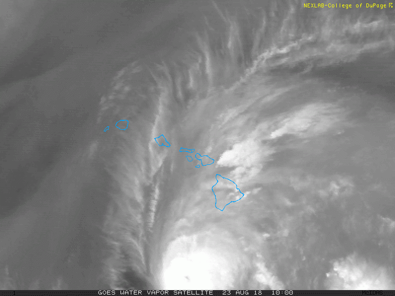
Water vapor imagery loop last few hours with tropical moisture flooding the Big Island from the south; courtesy NOAA/GOES, College of DuPage
Overview
Hurricane Lane weakened some in the past 24 hours as it has encountered increased southwesterly wind shear, but it remains a “major” category 4 storm as it slowly closes in on the Hawaiian Islands from the south. There is still a good chance that Hurricane Lane will not make actual landfall on any of the island chain; however, it'll still generate tremendous amounts of rainfall on parts of the state and some sections can experience hurricane conditions (e.g., Maui, Oahu). The fact that it is a slow mover and will come close to the island chain will allow for a prolonged period of torrential rainfall, especially, on windward facing slopes with up to two or three feet possible on the Big Island. This is very likely not going to be the last tropical threat for Hawaii this season as warmer-than-normal sea surface temperatures and a developing El Nino in the central Pacific Ocean will likely aid in the formation of additional systems in coming days.
Details
Hurricane Lane is currently moving NW at 7 mph with 130 mph maximum sustained winds. Its central pressure is 949 millibars (28.03 inches) which is higher than the 935 millibars reading of yesterday Wednesday morning. This weakening has been the result of increased southwesterly wind shear which impacts the vertical structure of the tropical system and steady weakening is likely to continue during the next couple of days. Water vapor imagery shows Lane’s circulation becoming somewhat elongated and it is headed into an increasingly hostile environment. Hurricane-force winds extend outward up to 35 miles from the center and tropical-storm winds extend outward up to 140 miles. Tropical storm conditions have now arrived on portions of the Big Island with the potential of some damaging wind gusts and hurricane-force winds are possible on Maui and Oahu as the storm makes its closest approach on Friday.

Latest official storm track prediction with general movement to the north as a hurricane and then the west as a tropical storm; courtesy NOAA
In terms of rainfall, the close approach and very slow-movement of Hurricane Lane will cause rainfall amounts to pile up over the next few days – even without a landfall. The WNW storm track of yesterday has shifted to NW today and a more northerly track is likely by tonight and this is allowing Lane to creep closer and closer to the island chain from the south. This system should then shift to a more westerly direction on Friday afternoon and evening – likely just before making landfall on any of the islands. In other words, Lane will generally move northward as a hurricane and then westward as a weakened tropical storm. The movement of the storms remains at relatively low levels – currently around 7 mph. There have already been reports of more than a foot of rain on portions of the Big Island and ultimately some spots could see up to three feet of rain.

A dramatic turn to the north-northeast gave residents of Kauai little preparation time for the arrival of category 4 Hurricane Iniki in September 1992; map courtesy Wikipedia
Past history of Hawaii hurricanes
Hurricanes rarely make direct hits on the Hawaiian Islands and the last one to do so was Iniki in 1992 which became the most powerful storm to strike the islands in recorded history (and it interrupted the filming of the original Jurassic Park movie). Kauai bore the brunt of Iniki as it made landfall there on September 11th, 1992 as a category 4 storm after making a sudden and dramatic sharp turn to the north-northeast. This sudden shift in Iniki’s path left residents with less than 24 hours to prepare before it hit and the entire island lost power and telephone service. It would take years after landfall for the island to recover from the damage of Hurricane Iniki in 1992.

Four major hurricanes in the recent past that took a track within 100 miles of the current positioning of Hurricane Lane; maps courtesy wikipedia, information from Philip Klotzbach (Colorado State University)
Prior to Iniki, the last hurricane to make a direct hit on Hawaii was "Dot" in 1959. In fact, “Dot” is one of four major hurricanes in the past that moved to within 100 miles of the current position of Hurricane Lane. The other three such hurricanes were Dora in 1999, Emilia in 1994 and Fico in 1978.
Meteorologist Paul Dorian
Perspecta, Inc.
perspectaweather.com