
12:30 PM | ***Arctic air anchored by strong high pressure is holding its ground….wintry mix to continue this afternoon with slick conditions***
Paul Dorian

The combination of strong high pressure to the north and a developing secondary low pressure near the Mid-Atlantic coastline is helping to keep low-level cold air in place across suburban locations. Map courtesy NOAA
Overview
Arctic high pressure centered over southeastern Canada continues to funnel cold air down the Northeast US coastline and into the Mid-Atlantic region. This cold, dense air is holding its ground in many suburban spots along the Philly-to-NYC corridor and warmer air advancing northward along the eastern seaboard is being forced up into the upper part of the atmosphere. As a result, low-level temperatures remain at or below freezing in many suburban locations and precipitation-type is bouncing back-and-forth between sleet and freezing rain depending on intensity and snow is even falling in some spots. As the wintry mix continues this afternoon, slick road conditions will persist and ice can build up on untreated surfaces.
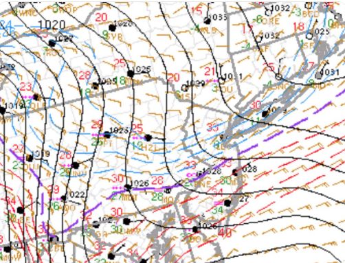
The freezing line (purple) has been very reluctant to advance to the north so far today given the strong, cold high pressure system anchored to the north. Map courtesy NOAA, NYNJPA Weather
Discussion
Primary low pressure is pushing up to the west of the I-95 corridor at mid-day while a secondary low is forming near the Mid-Atlantic coastline. At the same time, very strong and cold high pressure is anchored over southeastern Canada and that is the reason the entrenched cold air mass is reluctant to give up its ground. Temperatures should remain at or below freezing in many suburban locations this afternoon and precipitation will vary between sleet and freezing rain with snowflakes possibly mixing in as well. The general trend has been for sleet to fall when the precipitation becomes heavier and for rain to fall when it lightens up. Temperatures in the city of Philly have managed to get slightly above freezing and this is resulting in generally plain rain in the immediate metro area. By late today or early tonight, it is possible that enough warmer air works its way in at lower-levels of the atmosphere to boost surface temperatures to above freezing in the suburbs, but it’ll stay quite slick until we get to that point.
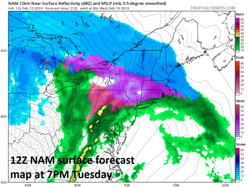
Above freezing temperatures possible in the suburbs by early tonight (12Z NAM forecast map for 7PM); map courtesy NOAA, tropicaltidbits.com
Looking ahead, the overall weather pattern continues to look quite active. There will likely be a rain event late in the work week, but then multiple threats for wintry weather will begin this weekend and continue well into next week.
Meteorologist Paul Dorian
Perspecta, Inc.
perspectaweather.com
Video discussion: