9:30 AM (Thursday) | ***Severe weather threat later today and tonight includes the risk of tornadoes***
Paul Dorian
Very impressive radar echoes already in place across the Ohio Valley; map courtesy NOAA, University of Wisconsin
Overview
One of the most well-known tornado outbreaks in Pennsylvania took place at the end of May in 1985 and, quite ominously, there are some similarities between the pattern then and the one setting up for later today and tonight. Similar to the setup back in 1985, an upper-level disturbance will drop southeastward from the Great Lakes and combine with an influx of very warm and humid air to raise the chances for severe weather here which may very well include the risk of tornadoes.
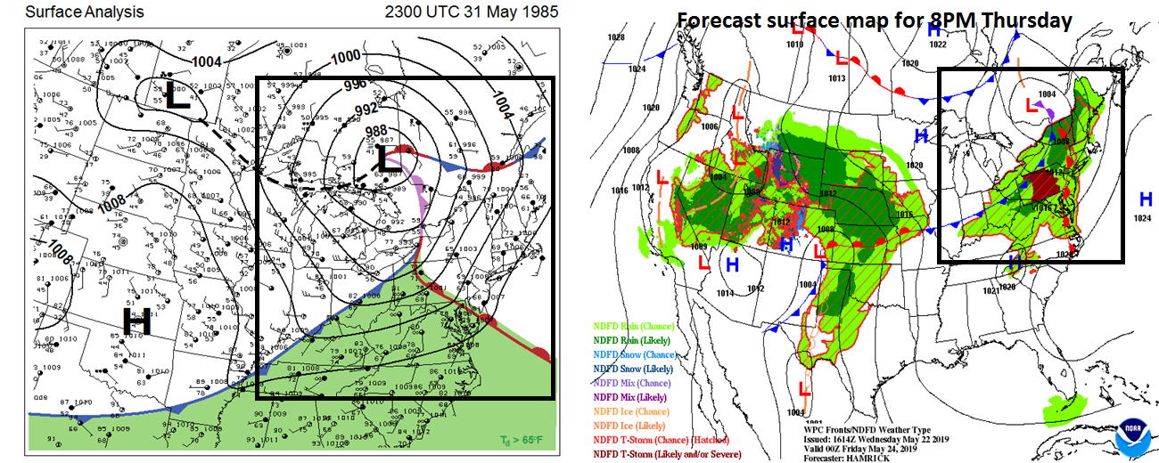
There are some similarities to today’s atmospheric setup and that which resulted in an outbreak of tornadoes across Pennsylvania on May 31, 1985 (surface map 5/31/85 on left, surface forecast map for this evening on right).
Discussion
May 31, 1985 is one of the most well-known tornado outbreaks across Pennsylvania in recent history and there are some similarities to today’s setup which certainly raises red flags in the meteorological community. Yesterday was a very comfortable day in the Mid-Atlantic region, but the arrival of a warm front early today has brought showers and thunderstorms to parts of the area and it’ll turn warmer and more humid as the day progresses. The combination of this increasingly warm and humid air mass with vigorous energy in the upper part of the atmosphere dropping southeastward from the Great Lakes - similar to May 31, 1985 - will likely result in an area of thunderstorms by mid-day extending from the western part of Pennsylvania to central West Virginia. This upper-level feature is riding around the top of a strong upper-level ridge of high pressure that is relatively stationary over the southeast US where there has been a relentless heat wave. The greatest chance for severe weather later today and tonight will be across Pennsylvania and Maryland, but the threat exists as far south as the DC metro region. There may end up being multiples lines of storms to monitor through the day with one line to deal with from mid-to-late afternoon and then another this evening.
There are some similarities to today’s atmospheric setup and that which resulted in an outbreak of tornadoes across Pennsylvania on May 31, 1985 (500 mb map 5/31/85 on left, 500 mb forecast map for this evening on right).
Following the active weather of late today and tonight, high pressure will take control again on Friday and there will be a noticeable drop in humidity along with comfortably warm conditions. A somewhat similar active weather pattern may repeat itself later Saturday and Saturday night with a renewed threat of strong-to-severe thunderstorm activity in the Mid-Atlantic/NE US as another wave of energy rides around the top of the strong upper-level ridge of high pressure based in the southeastern states.
Meteorologist Paul Dorian
Perspecta, Inc.
perspectaweather.com
Video discussion:


