11:45 AM (Mon.) | ****Rain changing to snow from NW-to-SE in the Mid-Atlantic…N/W suburbs should see small accumulations…mid-week major storm to bring accumulating snow, ice, rain, strong winds*****
Paul Dorian

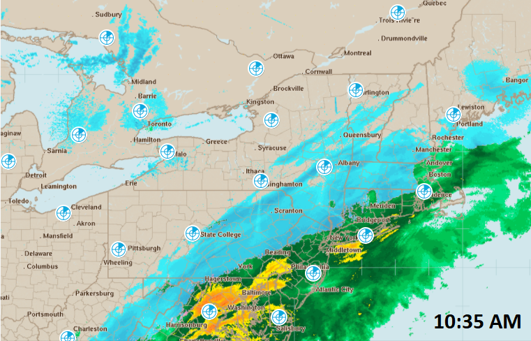
As colder air filters into the Mid-Atlantic region, rain is changing to snow from northwest-to-southeast and this trend will continue into the afternoon. Map courtesy NOAA, Weather Underground
Overview
This will be a stormy week in the Mid-Atlantic region with two storms to deal with during the next few days. The first storm has already brought some heavy rainfall to the DC-to-Philly-to-NYC corridor and as colder air filters in from a strengthening high pressure system to the north, a changeover to snow is taking place from northwest to southeast. A second and high impact storm will arrive at mid-week and it is likely to result in accumulating snow, ice, rain and strong winds for the Mid-Atlantic region.
Storm 1 (Today):
The day started off with rain in the DC-to-Philly-to-NYC corridor and some of it has fallen heavily at times. Temperatures reached a peak early in the day in the I-95 corridor generally in the lower 40’s, but as high pressure slowly builds into southeastern Canada, colder air is filtering into the Mid-Atlantic region. As a result, the rain is changing to snow in the Mid-Atlantic region from the northwest to the southeast. Most suburban locations to the north and west of DC, Philly and New York City will see a mixing with or a changeover to snow over the next couple of hours. There can even be some small accumulations of up to a couple of inches or so before it winds down later in the day; primarily, on grassy surfaces and north of the PA/MD border. The roads are rather warm following the very mild conditions of yesterday, but still need to watch out for possible slick spots later this afternoon. The low pressure system will push off the Mid-Atlantic coastline at day’s end and it’ll clear and become quite cold in the overnight hours. As high pressure continues to build across SE Canada on Tuesday, the weather will be dry and quite cold in the Mid-Atlantic for the middle of December.

The mid-week storm may feature an initial round of snow followed by a period of sleet, freezing rain and/or rain and then a change back to snow at night. This particular forecast by the 12Z GFS suggests it could be snowing quite heavily in DC, Philly and NYC during the wee hours of Thursday morning. Map courtesy NOAA, tropicaltidbits.com
Storm 2 (Wednesday into Thursday):
On Wednesday, a significant winter storm will head towards the Mid-Atlantic region and strong, cold high pressure will be anchored across SE Canada. This mid-week winter storm will bring accumulating snow to much of the Mid-Atlantic region and there will be ice and rain as well during this event. The big cities along the I-95 corridor will likely become the battle zone region in terms of precipitation-type with a possible sequence of events as follows: snow at the onset followed by a period of sleet, freezing rain and/or rain followed by a change back to all snow. Snowfall amounts will be somewhat limited in the big cities by this expected period of mixed precipitation. The period of mixed precipitation will be shorter in the nearby N/W suburbs of the big cities and snow will dominate throughout the storm in the far northern and western suburbs. As a result, there will be quite a sharp gradient in terms of snowfall amounts over a short distance from the metro regions to their outer northern and western suburbs. Rain is likely to be the main precipitation type in the area from southeastern Virginia to the southern half of the Delmarva Peninsula to the southern part of New Jersey.

The upper-air pattern on Wednesday will feature high-latitude blocking across Greenland/northern Canada and this will result in a very cold air mass for the Northeast US/Mid-Atlantic region as a storm approaches from the Tennessee Valley. Map courtesy NOAA, tropicaltidbits.com
Preliminary snowfall estimates are as follows and are subject to change as a small shift in the storm track can make a big difference:
DC: 2-4 inches in the District, 4-8 inches in the N/W suburbs
Philly: 4-8 inches in Philly, 6-12 inches in the N/W suburbs
NYC: 6-12 inches throughout the metro region

A forecast map of winds gusts for the mid-week storm as depicted by the 06Z Euro and they can reach 40+ mph at inland locations and 60+ mph along coastal sections. This type of strong wind would no doubt raise the chance for power outages in the Mid-Atlantic region. Map courtesy ECMWF, Weather Bell Analytics
One last note, winds will become quite strong during the mid-week storm with 40+ mph gusts at inland locations and 60+ mph gusts along coastal sections. As a result, in areas where snow piles up, there can be significant blowing and drifting and high wind gusts can increase chances for power outages in all areas; especially, those areas where ice builds up on tree limbs.
Meteorologist Paul Dorian
Perspecta, Inc.
perspectaweather.com
Follow us on Facebook, Twitter, YouTube
Extended video discussion: