12:15 PM | *Strong-to-severe thunderstorm threat along and east of Route I-95…very unstable air now centered over the Delmarva Peninsula/southern NJ...atmosphere will be "cleansed"*
Paul Dorian

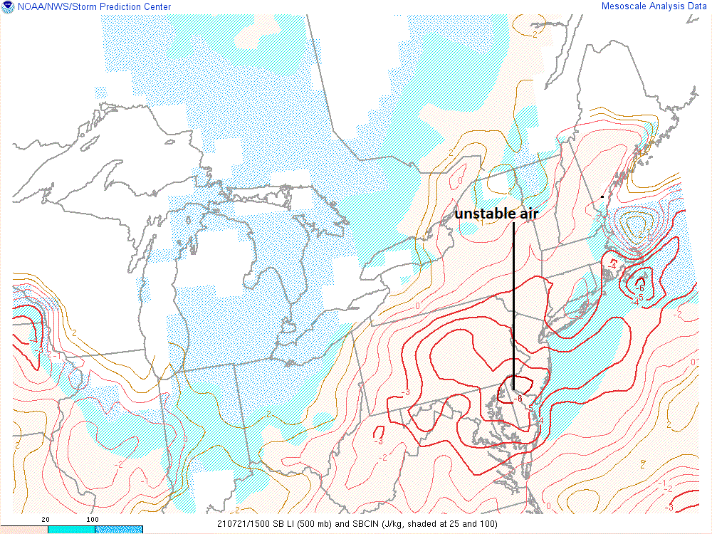
One measure of atmospheric stability is known as the “Lifted Index” and it is signaling the most unstable air sits over the Delmarva Peninsula at mid-day. Map courtesy NOAA
Overview
The combination of an unstable air mass, surface frontal system, and an approaching upper-level trough is resulting in thunderstorm development across portions of the interior Mid-Atlantic at mid-day and some of these will make it into the I-95 corridor later this afternoon. Any afternoon or early evening thunderstorm can contain brief downpours, damaging wind gusts, hail and frequent lightning. The most unstable air seems to be situated over the Delmarva Peninsula and southern part of New Jersey and this zone can get especially hard hit later in the day with severe storm activity. The front should sweep away some of the haze that has been in the region during the past couple of days and it’ll be a refreshing day on Thursday with comfortable temperatures and humidity levels.

Intensity and coverage of radar echoes will increase over the next couple of hours as an upper-level trough approaches the Mid-Atlantic region. Map courtesy College of DuPage, NOAA
Details
Thunderstorms are erupting at mid-day from West Virginia to interior PA to northern NJ and some of these storms will make it to the DC-to-Philly-to-NYC corridor later in the afternoon. A couple of instability parameters indicate the most unstable air is now situated over the Delmarva Peninsula and southern part of New Jersey and this elevates the chances there for severe thunderstorm activity.

Another atmospheric stability parameter known as the CAPE supports the idea that very unstable air is situated over the Delmarva Peninsula. Map courtesy NOAA
The cold front responsible for this storm activity will sweep off the eastern seaboard later tonight and it’ll usher in a very comfortable air mass for the latter part of July. In addition, the smoke-filled skies of recent days should be “cleansed” by this approaching air mass to go along with quite comfortable temperature and humidity levels. The reasonable temperatures for late July should continue on Friday and Saturday in the Mid-Atlantic region and then the chance for showers and storms will rise again early next week.
Meteorologist Paul Dorian
Peraton
peratonweather.com
Follow us on Facebook, Twitter, YouTube
Video discussion: