
1:30 PM | ***Severe weather threat focused today on central/eastern Texas…threat area shifts east a bit on Tuesday to Louisiana, Mississippi and Alabama***
Paul Dorian

Severe weather is a threat for today and tonight in the central and eastern parts of Texas and a deep upper-level trough is a key contributor. Map courtesy NOAA, Pivotal Weather
Overview
Spring season has begun and with it comes the threat of severe weather across much of the southern US during the next few days. Many ingredients are coming together for a severe weather event later today and tonight that will be focused on the central and eastern parts of Texas and this threat zone will shift slightly to the east on Tuesday encompassing the region from Louisiana-to-Mississippi-to-Alabama. A primary culprit in this unfolding scenario is an expansive upper-level trough whose base is now centered over the Southwest US and will shift only slightly to the east on Tuesday. In addition, there is a clash of air masses setting up in this part of the nation with cold, dry air sweeping eastward from the southwestern states into a very warm and humid air mass out ahead of it over the eastern half of Texas.

Severe weather threat will shift a bit to the east on Tuesday with a focus of concern in the region from Louisiana-to-Mississippi-to-Alabama and a deep upper-level trough will again be a key contributor. Map courtesy NOAA, Pivotal Weather
Details
There is a moderate risk of severe thunderstorms later today and tonight across central and eastern Texas and this unfolding scenario can include the formation of several tornadoes along with very large hail and damaging wind gusts. The threat zone for severe weather can extend from Texas into the far reaches of western Louisiana by later tonight. At mid-day, a closed upper-level trough was pushing eastward over New Mexico with an associated powerful upper-level jet streak of over 90 knots. The air across eastern Texas is becoming increasingly humid this afternoon (dew points rising to the 70s) and this will help to destabilize the atmosphere by later in the day. A low-level jet streak will play a role as well as it shifts eastward into the picture later in the evening – adding to the possibility of damaging wind gusts.

NOAA’s Storm Prediction Center (SPC) has issued a “moderate” alert today for severe weather in central and eastern Texas.
On Tuesday, the overall severe weather threat zone will shift to the region of Louisiana, Mississippi and Alabama as the upper-level trough slides somewhat to the east from today’s location. At the surface, low pressure will likely setup over Kansas with a trailing cold front across eastern Texas. Colder and drier air to the west of the front will clash once again with much warmer and more humid to the east on Tuesday setting the stage for another day of severe weather. This low pressure system will head to the northeast later tomorrow reaching Illinois by tomorrow night with the cold front tailing southward into the Tennessee Valley.
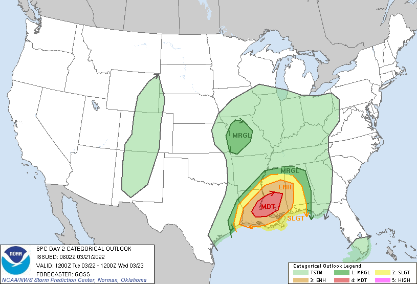
NOAA’s Storm Prediction Center (SPC) has issued a “moderate” alert on Tuesday for severe weather in east-central Louisiana and much of the southern half of Mississippi. The severe weather threat on Tuesday will extend eastward into the state of Alabama.