3:00 PM (Thursday) | **Lee is now a category 1 hurricane and moving due north…on a path towards the Bay of Fundy in Atlantic Canada - known for its extreme tidal variations**
Paul Dorian

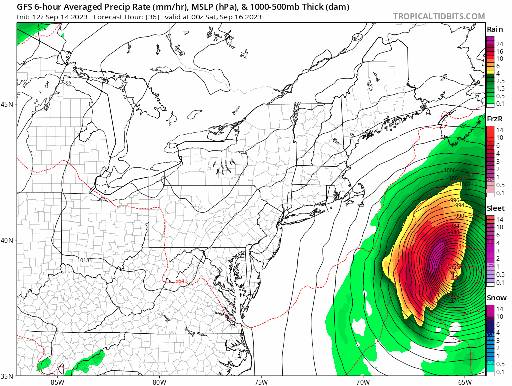
The projected path of Hurricane Lee will bring it to a position right near the Bay of Fundy by later Saturday. Maps courtesy NOAA, tropicaltidbits.com (24-hour loop of surface forecast maps by 12Z GFS from Friday evening to Saturday evening)
Overview
Hurricane Lee has weakened in recent hours and is now classified as a category 1 “minimal” hurricane as it heads on a northerly track. It is likely to be downgraded to tropical storm status (or “post-tropical”) by the weekend as it moves over colder waters of the NW Atlantic and reaches higher latitudes near coastal Maine/Atlantic Canada. However, Hurricane Lee remains a large storm and its pressure gradient field will remain intense likely resulting in an impact that will be felt across eastern New England and Atlantic Canada with powerful winds and heavy rainfall. Hurricane-force winds are on the table along coastal Maine and Atlantic Canada with tropical storm force winds likely along coastal Massachusetts, New Hampshire and Rhode Island. The expected track of Hurricane Lee will place the storm right near or over the Bay of Fundy by later Saturday – a bay known for its extremely high tides and tremendous tidal variations.

The water cools down quite a bit off of eastern New England (circled area) and this will likely result in a continuing lowering of Lee’s central pressure in the several hours before landfall. However, Lee will remain a large storm with an intense pressure gradient field and winds can be significant across eastern New England and Atlantic Canada from later tomorrow into the latter part of the weekend. Map courtesy NOAA, tropicaltidbits.com
Details
Hurricane Lee has maximum sustained winds of 85 mph at 2 PM on Thursday and is moving due north at 14 mph. While the central pressure of Hurricane Lee has weakened in recent hours (now 957 millibars or 28.56 inches), it remains a large hurricane with hurricane-force winds extending outward up to about 90 miles from its center and tropical-storm force winds out to about 300 miles. On its current path, Hurricane Lee will likely bring tropical storm conditions to eastern New England by Friday afternoon including Cape Cod, Martha’s Vineyard, Nantucket (MA) and likely hurricane force winds to Down East Maine and Atlantic Canada on Saturday.

The Bay of Fundy features the world’s largest tidal variations due to its funnel shape and its depth. Map courtesy NOAA
By late Saturday, Lee is likely to have been downgraded to tropical storm or “post-tropical” status as it climbs over colder waters of the NW Atlantic. This expected path could bring this powerful storm system to right over or very close to the Bay of Fundy by late Saturday. The Bay of Fundy is known for its extremely high tides and features the world’s largest tidal variations due primarily to the funnel shape of the bay and its depth. While the Earth's average tide-driven variation in sea level is three feet, the water level near Wolfville, in Nova Scotia's Minas Basin, can be as much as 53 feet (16 meters) higher than at low tide. By the way, high tide on Saturday at St. John, New Brunswick is approximately 1:30 pm (more info here).

Hurricane Lee will move on a general northward track over the next few days which should bring it to near or over the Bay of Fundy in Atlantic Canada by later Saturday. Map courtesy Tomer Burg, NOAA, ECMWF, UKMET
Looking ahead, there is another tropical system in the eastern Atlantic Ocean that has the strong likelihood of intensifying into a hurricane as it treks across the tropical Atlantic. There are some signs that this system may ultimately pose a similar threat as Lee to eastern New England and/or Atlantic Canada, but there are many days to go to iron out those details. An interesting thing to monitor in coming days will be to see if the passage of Hurricane Lee generates a “cold wake” (through upwelling) in the western Atlantic as did Hurricane Franklin in the preceding days.
Meteorologist Paul Dorian
Arcfield
arcfieldweather.com
Follow us on Facebook, Twitter, YouTube