
9:30 AM (Sunday) - ***Another “major” hurricane may be headed towards Florida’s Gulf coast…possible mid-week landfall right near the Tampa Bay region***
Paul Dorian
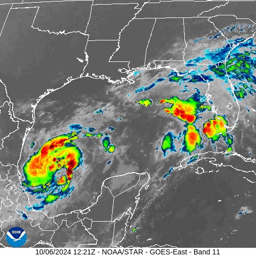
Milton is now a strong tropical storm located over the very warm waters of the southwestern Gulf of Mexico and it can become a category 1 hurricane later in the day. Images courtesy NOAA/GOES-East
Overview
Another “major” hurricane may be headed towards Florida’s Gulf coast with a possible mid-week landfall right near the Tampa Bay region. “Milton” became a named tropical storm on Saturday over the southwestern Gulf of Mexico and it is likely to attain hurricane status by later Sunday as it begins a move to the east. Given the generally favorable environmental conditions, Milton could then become a “major” hurricane as early as Monday as it continues on a trek towards Florida’s west coast.

Numerous computer forecast models support the notion of a midweek landfall hurricane somewhere along the west coast of Florida and perhaps right in the Tampa Bay region. Map courtesy tropicaltidbits.com
Details
Just several days ago, Hurricane Helene reached Florida’s “Big Bend” region as a northward-moving “major” hurricane which then moved through the state of Georgia before stalling out over the Tennessee Valley. Another “major” hurricane may be headed to Florida’s Gulf coast by the middle of this week, and indications are that this system may make a landfall somewhere down the west coast…perhaps right in the Tampa Bay region. After a possible midweek landfall, instead of moving north into Georgia as did Hurricane Helene, Milton is destined to cross over the Florida Peninsula in a northeastward fashion and end up over the open waters of the southwestern Atlantic Ocean by the end of the week.

Sea surface temperatures are abnormally high across the Gulf of Mexico (circled region) for early October including immediately along the west coast of Florida where there may be a landfalling hurricane at mid-week. Map courtesy NOAA, tropicaltidbits.com
Hurricane Helene produced severe flooding across the southern Appalachians and a big contributor to the devastation there was the “pre-hurricane” rainfall of as much as ten inches in spots…all before Helene’s tropical moisture even reached the region. A worrisome occurrence with respect to this current unfolding scenario is that “pre-hurricane” rainfall is already taking place over much of Florida and – as was the case with Helene – this could set the stage for serious flooding later in the week with the expected arrival of deep tropical moisture associated with Milton. It is still too early to provide too many details about this potential hurricane hit in Florida later this week, but it is not out of the question to say that a foot or more of rain can place between now and the latter part of the week.
In terms of storm surge, the most significant impact with respect to a landfalling hurricane is typically on the right side of the storm’s center as the forward speed of the storm tends to combine with surface winds in an “additive” manner. If indeed this hurricane moves towards the west-central Gulf coast of Florida at mid-week in a southwest-to-northeast fashion, then the worst-case scenario for Tampa Bay would be landfall just up the coast from there as this would put the region on the storm center’s right side and likely enhance storm surge in the bay itself….still too early for those kind of details, but it is something that is on the table.
One final (and hopeful) note, Milton is currently a rather small storm system which does make it somewhat more vulnerable to strong wind shear and dry air intrusion and that is something that is on the table across the eastern Gulf of Mexico in the hours just before landfall. In fact, one “best case” scenario has Milton reaching its maximum intensity out over the central Gulf of Mexico and then experiencing significant weakening in the hours just before landfall due to strong wind shear and dry air intrusion.
Bottom line, stay tuned…many details are still to be ironed out. However, it is certainly prudent to begin the usual preparations in Florida for a possible mid-week landfalling “major” hurricane anywhere along the west coast while, at the same time, hoping for the “best case scenario” that features some significant weakening just before landfall.
Meteorologist Paul Dorian
Arcfield
arcfieldweather.com