4:30 PM | ***Southern storm to bring accumulating snow and ice to unusual places between tonight and early Wednesday***
Paul Dorian
18Z HRRR forecast map of total snowfall by early Wednesday feature accumulations all the way from Texas to Florida to the Carolinas. Map courtesy NOAA, tropicaltidbits.com
Overview
A rare weather event is about to commence across the southern states that will result in accumulating snow and ice to unusual places such as Houston (TX), New Orleans (LA), Tallahassee (FL), and Myrtle Beach (SC). The first three of these cities listed are under “Winter Storm Warnings” and Myrtle Beach is currently under a “Winter Storm Watch”…a very rare event indeed. In this entire stretch, there can be a few inches of snow between tonight and early Wednesday and an ice glaze may be included in the mix as well. Arctic air that has settled all the way down to the Gulf coast is the main contributor to this very wintry and rare weather event for the southern US.
Icing can be rather significant across northern Florida by the time we get to mid-week thanks to Arctic air that has penetrated to the Gulf region and plenty of Gulf moisture. Map courtesy Canadian Met Centre, Pivotal Weather
Details
Moisture is now gathering over the northwestern Gulf of Mexico as evening approaches and the southeastern part of Texas will be the first in the South to experience winter weather from this upcoming rare weather event. As an example, a combination of rain, sleet and snow is likely later tonight across Houston and there can be a few inches of snow and ice accumulation by tomorrow morning. Farther east, snow can break out by daybreak Tuesday in New Orleans and there can be as much as 3-5 inches by late tomorrow in The Big Easy…rare indeed and it could be the highest snowfall there in a single storm in over 100 years.
After the wintry precipitation tonight and tomorrow, temperatures will drop to unusually low levels across Texas by early Wednesday morning. Map courtesy ECMWF, Weather Bell Analytics
In the Florida Panhandle, rain is likely to break out late Tuesday and then it should cold enough tomorrow night in Tallahassee for a mix of snow and sleet and a couple inches of snow/ice accumulations are possible there by early Wednesday. Just to the south and east of Tallahassee, there can actually significant ice buildup in much of the northern part of The Sunshine State. In Myrtle Beach, South Carolina, snow can break out late tomorrow and continue into early Wednesday with a couple inches of accumulation possible by then in that southern region. In all of these southern locations, snow plows are likely hard-to-come-by and have been rarely used. Blizzard conditions will develop in some of these areas such as along I-10 in Florida and travel, of course, will become virtually impossible…quite the Arctic outbreak.
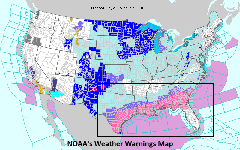
It is rare indeed to see “Winter Storm Warnings and Watches” extend from Texas to Florida to the Carolinas…all made possible by an Arctic outbreak that has virtually enveloped the entire nation. Map courtesy NOAA
Meteorologist Paul Dorian
Arcfield
arcfieldweather.com


