**El Nino intensifying across the central Pacific...comparison with recent strong events and a possible "analog" year...potential implications on the winter**
Paul Dorian
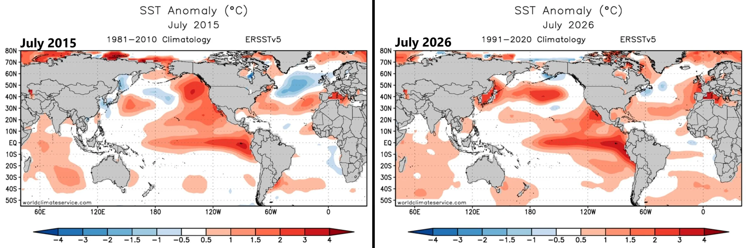
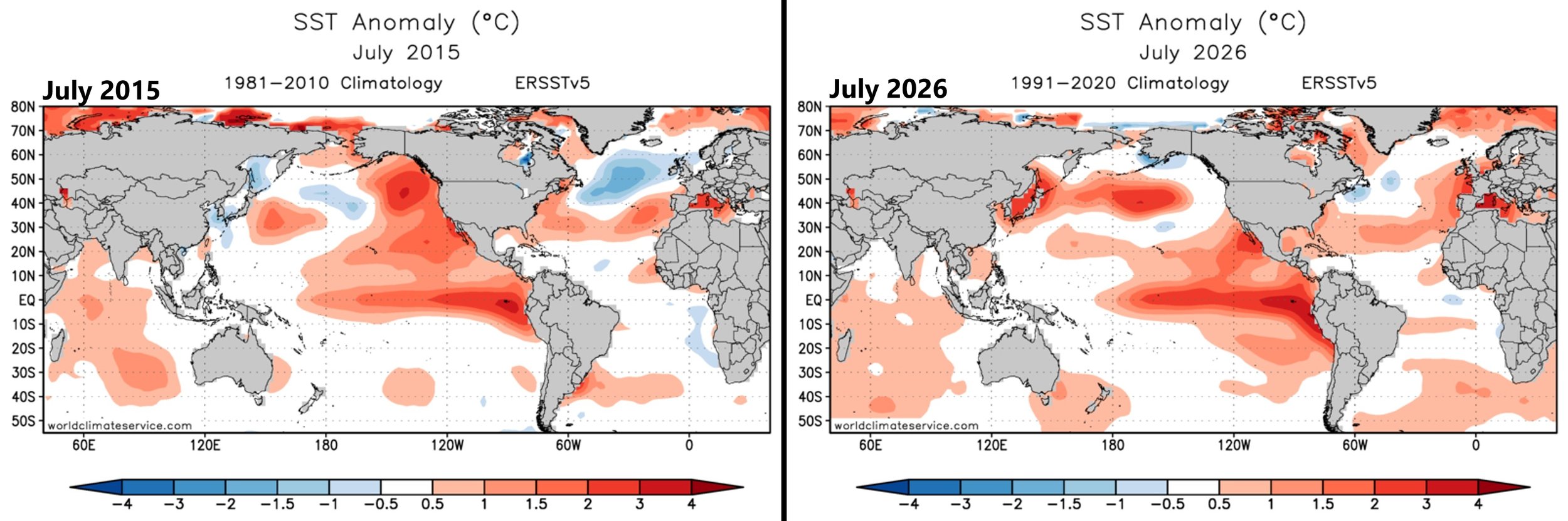
A comparison of sea surface temperature anomalies between the full month of July 2015 (left) to 2026 (right) show many similarities in both the Pacifica and Atlantic Oceans. Maps courtesy NOAA
Overview
El Nino continues to intensify across the central Pacific Ocean with sea surface temperatures rising to their highest levels so far this summer season. In fact, the latest water temperatures in the region known as “3.4” are now more than two degrees above-normal which places this El Nino event into the “strong” category and, when all is said and done, it’ll likely rival the greats of recent history including 1982-1983, 1997-1998, and 2015-2016.
In comparison with the sea surface temperatures anomalies for the full month of July with the El Nino episode of 2015-2016, many similarities appear on the maps. This specific comparison will be interesting to follow in coming months to determine if 2015-2016 could be used as an analog year for the upcoming winter outlook and provide us with some clues as to what we might expect late this year and early next year. Interestingly, the last blizzard that produced 2 feet of snow all along the DC-to-Philly-to-NYC corridor took place in late January of 2016 during the late stages of that El Nino event.
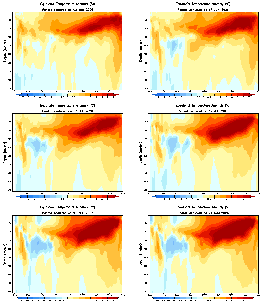
Deep sea buoys continue to feature much warmer-than-normal water just beneath the surface across the eastern Pacific and some of this will “bubble up” to the surface level in coming weeks. Maps courtesy NOAA
Details
The last several days have featured a surge of water temperatures across the central Pacific Ocean region known as “3.4” to the point where they are now more than two degrees above normal which generally is considered to be the threshold for declaring El Nino as a “strong” event. At the same time, water temperature anomalies in the eastern Pacific region known as “1+2” have dropped in recent days though actual temperatures are still well above normal… interesting to see if these two trends continue.
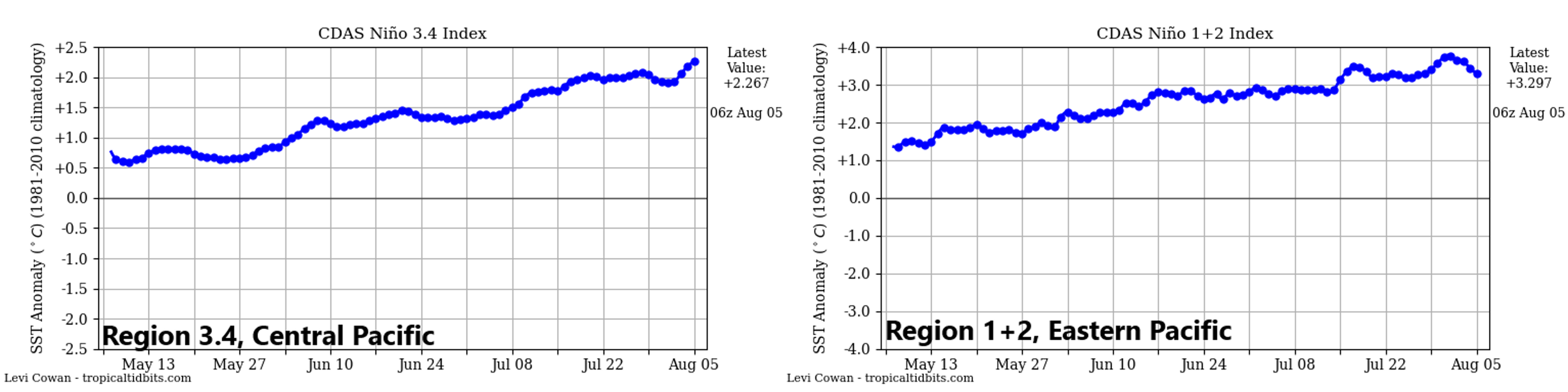
Water temperatures have surged in recent days across the central Pacific (left plot) while at the same time they have dropped some in the eastern Pacific (right plot) though still well above-normal. Plots courtesy NOAA, tropicaltidbits.com
In a comparison of the sea surface temperature anomalies for the full month of July, many similarities appear between this current El Nino and the “strong” episode that took place in 2015-2016. Specifically, both months featured the warmer-than-normal water across the equatorial part of the Pacific with the highest temperatures relative-to-normal just off the west coast of South America (i.e., in the eastern Pacific). Also, in both cases, there was plenty of warmer-than-normal water to the north and northwest of the equatorial region across portions of the central and northern Pacific. In addition, in both cases the Atlantic Ocean featured a band of warmer-than-normal water along the 30 degrees North latitude which extended all the way into Europe’s Mediterranean Sea. Probably the biggest difference between July 2015 and July 2026 in terms of water temperature anomalies was across the northern Atlantic where 2015 featured a large area of much cooler-than-normal conditions. But even with respect to that specific comparison, the water temperatures this past July showed some areas of below-normal conditions though not as strong or as widespread as in 2015.
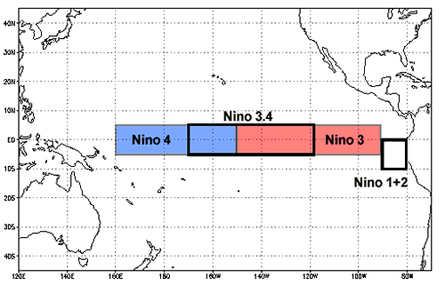
The region known as “3.4” is located in the central part of the equatorial Pacific Ocean and “1+2” lies across the eastern sections.
In preparation for any long-term outlook such as for the winter season or the tropical season, I like to find analog years in the past that resemble the current sea surface temperature patterns, and it’ll be interesting to monitor to see if 2015-2016 continues to have similarities to the on-going El Nino event. As it turns out, the last snowstorm that produced about 2 feet of snow all along the DC-to-Philly-to-NYC corridor took place in late January of 2016…near the last stages of that strong El Nino event…just saying.
Meteorologist Paul Dorian
Arcfield
arcfieldweather.com
Follow us on Facebook, Twitter, YouTube
Video discussion: