Contact Us

Use the form on the right to contact us.

You can edit the text in this area, and change where the contact form on the right submits to, by entering edit mode using the modes on the bottom right. 


123 Street Avenue, City Town, 99999

(123) 555-6789

email@address.com


You can set your address, phone number, email and site description in the settings tab.
Link to read me page with more information.

backlit-stratus-clouds-2013-04-05.jpg

Blog

Weather forecasting and analysis, space and historic events, climate information

Filtering by Category: DC

7:00 AM | Showers likely during the late morning and mid-day hours; much warmer on Tuesday; heavy rain event later Wednesday into Thursday

Paul Dorian

6-Day Forecast

Today

Mostly cloudy, still a bit on the cool side, but milder than yesterday, showers likely during the late morning and mid-day hours, highs in the mid 60’s

Tonight

Mostly cloudy and mild, a few showers possible, patchy fog late, lows in the lower 60’s

Tuesday

Much warmer with a mix of sun and clouds, highs reaching the upper 70’s

Tuesday Night

Mostly cloudy, mild, maybe a shower or two, patchy fog possible late, low-to-mid 60’s

Wednesday

Mostly cloudy, breezy, mild, showers and thunderstorms likely late in the day or at night, some of the rain can be heavy at times, mid-to-upper 70’s

Thursday

Showers still likely, not as mild, near 70

Friday

Partly sunny, cooler, upper 60’s

Saturday

Partly sunny, cool, mid-to-upper 60’s

Discussion

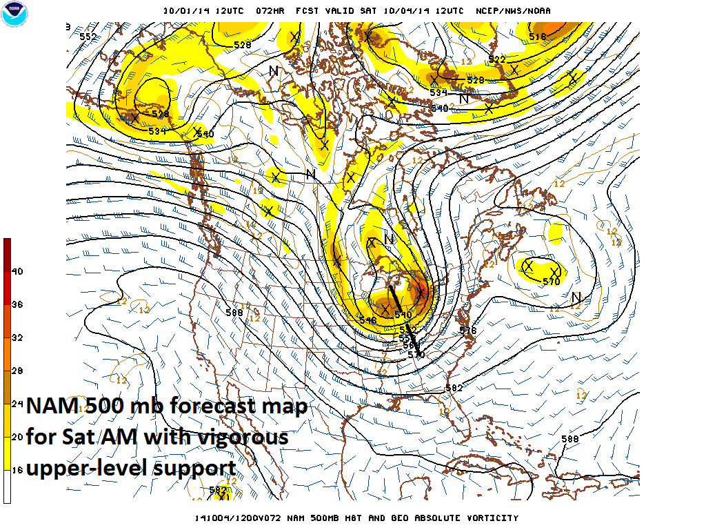
High pressure will shift off the Northeast coast today and southwesterly winds will develop on its backside by tomorrow pumping much milder air into the Mid-Atlantic region on Tuesday. It’ll stay mild on Wednesday ahead of a strong cold frontal system that will be approaching the east coast from the Midwest. This active front has the potential to generate heavy rain and strong thunderstorms in the region late Wednesday into Thursday before drier air returns late in the week.

Video

httpv://youtu.be/br8r-R0Fpec

7:00 AM | A soaking rain event arrives today courtesy of low pressure riding along a frontal boundary zone; ugly-looking weather for the Orioles this evening; another soaking rain event by the middle of next week

Paul Dorian

6-Day Forecast

Today

Cloudy, quite chilly for this time of year, showers develop by mid-day and evolve into a steadier rainfall by the end of the day, highs in the low-to-mid 60’s

Tonight

Cloudy and cool with periods of rain, lows in the lower 50’s

Saturday

Cloudy in the morning with lingering rain possible, quite cool, some clearing possible late, low 60’s

Saturday Night

Becoming partly cloudy, chilly, mid 40's

Sunday

Partly sunny, still quite cool, a few showers are possible, low 60’s

Monday

Mostly cloudy, not as cool, breezy, showers possible, near 70

Tuesday

Mostly cloudy, breezy, mild, showers possible in the afternoon, heavy rain and strong thunderstorms possible overnight, low-to-mid 70’s

Wednesday

Mostly cloudy, breezy, not as mild, still the threat for showers and thunderstorms and some of the rain can be heavy, upper 60’s

Discussion

Low pressure will ride along a frontal boundary zone over the next 12-24 hours and it’ll produce a soaking rainfall in the area from later today into early Saturday. High pressure should help improve conditions somewhat later tomorrow afternoon and for Sunday with some sunshine likely returning as we progress through the weekend. As the high shifts off the coast early next week, it’ll turn milder after this unusually cool stretch of weather and heavy rain is likely by the middle of next week along with possible strong thunderstorms as a strong cold front along closes in on the east coast.

Video

httpv://youtu.be/Tw6W95Qxfbw

7:00 AM | Low pressure to bring soaking rain around here tomorrow night; weekend is somewhat unsettled; heavy rain event likely next week

Paul Dorian

6-Day Forecast

Today

Mostly sunny, cool, a bit breezy at times, highs near 70 degrees (normal high is 71 degrees at DCA)

Tonight

Increasing clouds, cool, cannot rule out the chance for a shower towards morning, lows near 50 degrees

Friday

Mostly cloudy, cool, showers developing for the mid-day and afternoon hours, mid 60’s

Friday Night

Cloudy, cool, periods of rain, low 50's

Saturday

Cloudy in the morning with lingering showers possible, quite cool, some clearing likely late, low-to-mid 60’s

Sunday

Partly sunny, still quite cool, maybe a shower or two, low 60’s

Monday

Mostly cloudy, not as cool, breezy, showers possible, upper 60’s

Tuesday

Mostly cloudy, breezy, mild, showers and thunderstorms likely late in the day or at night and this could turn into a heavy rain event, low-to-mid 70’s

Discussion

High pressure will stay in control of our weather for another day, but even though there will be plenty of sunshine today, temperatures will be on the cool side and it’ll actually get even cooler over the next few days. Low pressure will ride along a frontal boundary zone later tomorrow and tomorrow night producing a soaking rainfall in the area going into early Saturday. High pressure should help improve conditions somewhat later Saturday and Sunday with some sunshine likely as we head through the latter part of the weekend, but another couple of showers cannot be ruled out. As the high shifts off the coast early next week, it'll turn milder and then a strong cold front is likely to bring a heavy rain event to the Mid-Atlantic region Tuesday night into Wednesday.

Video

httpv://youtu.be/WGz8iASN6e4

7:00 AM | Nice weather today and Thursday, but quite cool after that with more rain returning to the region

Paul Dorian

6-Day Forecast

Today

Mostly sunny, mild, becoming quite breezy, highs in the mid 70’s

Tonight

Mostly clear, turning quite cool, lows in the mid 40’s

Thursday

Mostly sunny, cool, near 70

Thursday Night

Becoming mostly cloudy, cool, maybe a shower towards morning, upper 40's

Friday

Cloudy, quite cool, showers likely, low60’s

Saturday

Mostly cloudy, quite cool, showers likely, low 60’s

Sunday

Mostly cloudy, still quite cool, showers still possible, low-to-mid 60’s

Monday

Mostly cloudy, not quite as cool, chance for showers, near 70

Discussion

Skies cleared nicely late last night to allow for pre-dawn viewing of the total lunar eclipse following the passage of a cold frontal system. That cold front pushed through the region overnight with some downpours and high pressure will now build back into the Mid-Atlantic region providing us with pretty pleasant weather for the next couple of days. While temperatures today will be rather mild for this time of year, they will drop to quite chilly levels in the overnight hours and it’ll get progressively cooler as the week progresses. Another batch of rain is likely to move into the I-95 corridor later Friday into Saturday associated with a frontal system and that front will stall nearby the region keeping us unsettled into early next week.

7:00 AM | A cold front brings rain to the region tonight along with the chance for a strong thunderstorm or two

Paul Dorian

6-Day Forecast

Today

Partly sunny, mild, breezy, highs in the mid 70’s

Tonight

Cloudy with periods of rain developing and there can be a strong thunderstorm or two containing gusty winds, cool, lows in the middle 50’s

Wednesday

Becoming mostly sunny, breezy, mild, mid 70’s

Wednesday Night

Mostly clear, turning chilly, mid 40’s

Thursday

Mostly sunny, cooler, low 70’s

Friday

Becoming mostly cloudy, quite cool, showers likely later in the day and at night, mid 60’s

Saturday

Mostly cloudy, quite cool, showers still possible, low 60’s

Sunday

Mostly cloudy, continued quite cool, chance for showers, low-to-mid 60’s

Discussion

A warm front passed through the region earlier today and we should now stay rain-free with partial sunshine and a stiff breeze from the south-to-southwest. A cold front will push through the area tonight generating periods of rain and possible strong thunderstorms as well. High pressure builds eastward into the Mid-Atlantic region for Wednesday and Thursday, but then another front will likely cause more rain around here later Friday into Saturday. In fact, that “end-of-the-week” front will likely stall nearby keeping us somewhat unsettled through the upcoming weekend. One final note, there is a total eclipse of the moon just before dawn tomorrow in the low western sky, but clouds could certainly produce poor viewing conditions in this area.

Video

httpv://youtu.be/3bl1lGPVL6c

7:00 AM | Temperatures rebound nicely today after a chilly start

Paul Dorian

6-Day Forecast

Today

Mostly sunny, still on the cool side, but noticeably milder than yesterday, cool, highs not far from 70 degrees

Tonight

Partly cloudy, cool, lows in the low-to-mid 50’s

Tuesday

Partly sunny, becoming breezy, cool, chance for showers late in the day, low 70’s

Tuesday Night

Mostly cloudy and cool with showers likely, mid 50’s

Wednesday

Mostly sunny, cool, low 70’s

Thursday

Mostly sunny, pleasantly cool, low 70’s

Friday

Partly sunny, cool, low 70’s

Saturday

Mostly sunny, cool, near 70

Discussion

The blast of chilly air that moved into the Mid-Atlantic region on Saturday will ease its grip today as temperatures rebound nicely from a chilly start to the day. In fact, the rebound will accelerate on Tuesday ahead of the next cold front as southwesterly winds boost afternoon temperatures into the 70’s. Showers will accompany the next frontal system later tomorrow and tomorrow night before another cool air mass arrives at mid-week.

7:00 AM | Nats game gets in before the rain arrives that is associated with a powerful cold front...coolest air yet for tomorrow night and Sunday

Paul Dorian

6-Day Forecast

Today

Partly sunny, becoming breezy late in the day, mild, highs in the mid 70’s

Tonight

Cloudy with periods of rain primarily after 10pm, maybe even a thunderstorm, breezy, cool, lows in the lower 60’s

Saturday

Clouds and lingering showers possible during the early morning, partial sunshine during the afternoon, breezy, cool, upper 60’s

Saturday Night

Very cool with mostly clear skies, breezy, lows not far from 40 degrees

Sunday

Mostly sunny, breezy, quite cool, near 60

Monday

Mostly sunny, still on the cool side, but milder than Sunday, near 70

Tuesday

Partly sunny, milder, becoming windy, showers likely late in the day and at night, low-to-mid 70's

Wednesday

Partly sunny, breezy, cooler, near 70

Discussion

A powerful cold front is racing towards the east coast and it will bring periods of rain to the region primarily after 10pm and into early Saturday along with the possibility of a thunderstorm or two. This frontal system has lots of upper-level support and thus can produce brief heavy downpours later tonight into early Saturday. Slow clearing will take place tomorrow afternoon and then some of the lowest temperatures seen all fall will take place by early Sunday morning with an outside chance at the upper 30's in some suburban locations. Highs on Sunday afternoon will struggle to pass the 60 degree mark which is well below normal for this time of year and there will be a noticeable cool breeze. Temperatures will rebound nicely on Monday; however, and then actually return to mild levels on Tuesday just ahead of the next cold front.

Video

httpv://youtu.be/BO2JIcF8ZwI

7:00 AM | Weather looks good for tonight's Orioles playoff opener and rain associated with the next strong cold front could hold off until after the Nats opener on Friday night

Paul Dorian

6-Day Forecast

Today

Becoming partly sunny after morning clouds with a touch of drizzle possible early, cool, highs in the mid 70’s

Tonight

Mostly cloudy, cool, maybe some drizzle late, lows near 60 degrees

Friday

Partly sunny, becoming breezy, cool, mid 70’s

Friday Night

Cloudy with periods of rain mainly after midnight, maybe a thunderstorm, breezy, cool, near 60

Saturday

Clouds and lingering showers early then becoming partly sunny, breezy and cool, upper 60’s

Sunday

Mostly sunny, quite cool, highs not far from 60 degrees

Monday

Mostly sunny, still cool, but milder than Sunday, near 70

Tuesday

Partly sunny, cool, near 70

Discussion

The weather looks quite good for tonight's Orioles playoff opener in Baltimore and rain associated with the next frontal system could hold off tomorrow night until after the Nats playoff opener. A powerful cold front is barrelling towards the east coast and it will be an important event in the typical autumnal transitional process of "stepping down" in temperatures from summer-to-winter. The month of September ended on Tuesday with high temperatures flirting near the 80 degree mark along the I-95 corridor and last weekend featured temperatures in the low-to-mid 80's - it'll be quite a challenge to see those kinds of high temperatures for quite awhile behind this front.

The upcoming frontal system will be mainly a "midnight-to-mid-morning" event around here from late tomorrow night into early Saturday with the threat for some heavy downpours and a possible thunderstorm. Slow clearing will hold off until later Saturday and it’ll occur from southwest-to-northeast in the Mid-Atlantic region (i.e., DC clears out well before NYC) as much cooler air pours into the area. Sunday will feature temperatures way below normal for early October and the cool weather pattern will continue on Monday and Tuesday although it won't be as chilly as it'll be on Sunday.

Video

httpv://youtu.be/OO42ll6VazY

1:30 PM | “Season-changing” type of frontal passage late Friday/early Saturday

Paul Dorian

500mb_fcst_NAM

Discussion

A powerful cold front is barreling towards the east coast and it could be a “season-changer”. The month of September ended yesterday with high temperatures flirting around the 80 degree mark along the I-95 corridor and last weekend featured temperatures in the low-to-middle 80’s from DC-to-Philly-to-New York City. It’ll likely be a real struggle to see those kinds of temperatures again this fall season - at least for a sustained basis - following the passage of the approaching strong cold frontal system.

The upcoming frontal system will bring with it the threat for downpours late Friday night and early Saturday along with embedded thunderstorms and gusty winds and it will be supported by vigorous upper-level energy (see forecast map). In fact, the upper level trough associated with the front will become “negatively-tilted” (i.e., oriented northwest-to-southeast) and this will lead to intensification and a "slowing-down" of its eastward movement. Slow clearing will likely hold off until later Saturday and it’ll take place from southwest-to-northeast (i.e., DC clears out well before NYC) as much cooler air pours into the Mid-Atlantic region. Sunday will feature temperatures way below normal for early October and the cool weather pattern will continue early next week - no low-to-middle 80's in sight.

7:00 AM | *Strong cold front at end of week to bring numerous showers and possible thunderstorms to the region*

Paul Dorian

6-Day Forecast

Today

Mostly cloudy with a little light rain or drizzle during the morning hours, partial sunshine this afternoon, a bit cooler than yesterday, highs in the mid 70’s

Tonight

Mostly cloudy, cool, patchy fog possible late, lows in the upper 50’s

Thursday

Partly sunny, cool, mid 70’s

Thursday Night

Mostly cloudy, cool, patchy fog and drizzle possible late, upper 50’s

Friday

Partly sunny, becoming breezy, cool, low-to-mid 70’s; showers and possible thunderstorms at night

Saturday

Early morning clouds and lingering showers give way to afternoon clearing skies, cool, mid-to-upper 60’s

Sunday

Mostly sunny, quite cool, low-to-mid 60’s

Monday

Mostly sunny, still cool, upper 60’s

Discussion

A weak cool front pushed through the area yesterday, but it is still close enough today to produce a few scattered showers in the Mid-Atlantic region. High pressure will take control of the weather around here by tomorrow, but then attention shifts to our west at the end of the week as a strong cold front barrels towards the east coast. That strong front will generate periods of rain around here Friday night and early Saturday with possible embedded thunderstorms and gusty winds. Much cooler air floods the Mid-Atlantic region for the second half of the weekend and highs on Sunday will be well below normal for this time of year.

Video

httpv://youtu.be/08Qau2g5gJc