Contact Us

Use the form on the right to contact us.

You can edit the text in this area, and change where the contact form on the right submits to, by entering edit mode using the modes on the bottom right. 


123 Street Avenue, City Town, 99999

(123) 555-6789

email@address.com


You can set your address, phone number, email and site description in the settings tab.
Link to read me page with more information.

backlit-stratus-clouds-2013-04-05.jpg

Blog

Weather forecasting and analysis, space and historic events, climate information

Filtering by Category: DC

12:30 PM | Wintry mix on Tuesday could generate slippery travel conditions in suburbs

Paul Dorian

GFS_Tues_PM
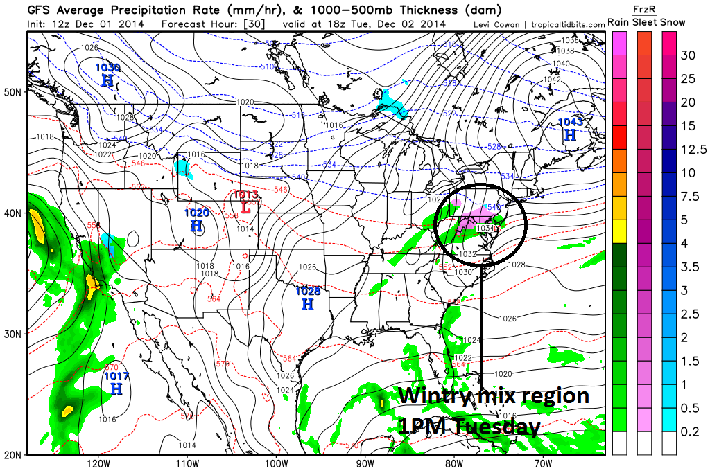
[12Z GFS forecast map for early Tuesday afternoon with "pink" region indicating mixed precipitation; map courtesy tropicaltidbits.com]

Discussion

Following today’s warmth, much colder air will filter into our region in the overnight hours following the passage of a strong cold front. This colder air mass will be anchored by strong Arctic high pressure to be situated tomorrow over New England (see forecast map) and low-level NE winds will bring about the dramatic change to our air temperatures. As warmer air tries to move up from the south on Tuesday, it will be forced to ride up and over the fresh low-level cold air mass and this will result in a wintry mix of rain, freezing rain, sleet and/or snow in parts of the I-95 corridor region from DC-to-Philly-to-New York City. Travel conditions could become slippery at times in suburban locations of the big cities; especially, higher elevation spots, beginning early in the day across the DC metro region and then later in the day from Philly to NYC. By late tomorrow night, the northward push of warmer air will succeed in eroding the shallow low-level cold air and temperatures are likely to rise gradually after midnight and some patchy fog may form as well. After a milder day on Wednesday, another cold front will usher in colder air for Thursday and Friday and the end result of that next frontal passage could be a repeat performance to close out the work week with more mixed precipitation possible on Friday.

7:00 AM | Quite mild today, but a wintry mix of rain, sleet and/or snow is likely on Tuesday

Paul Dorian

6-Day Forecast

Today

Mostly cloudy, quite mild, a few afternoon rain showers are likely, highs in the low-to-mid 60’s

Tonight

Mostly cloudy, breezy, turning colder, chance for a few rain showers early and snow and sleet possible late, lows by morning in the lower 30's

Tuesday

Mostly cloudy, much colder than today, a wintry mix of rain, sleet and/or snow likely, mid-to-upper 30’s

Tuesday Night

Mostly cloudy, cold, chance for a wintry mix early and the rain showers late, temperatures gradually rising in the overnight hours

Wednesday

Mostly cloudy, milder, chance for rain showers, low-to-mid 50’s

Thursday

Partly sunny, colder, upper 40’s

Friday

Mostly cloudy, cold, chance for a wintry mix of rain, sleet and/or snow, low 40’s

Saturday

Mostly cloudy, chilly, chance for rain showers, upper 40’s

Discussion

Normal high temperatures for today at Reagan National Airport (DCA) are 52 degrees and we'll climb well above that by this afternoon, but then the passage of a strong cold front in the overnight hours will bring in much colder air for Tuesday. Rain showers are likely this afternoon and early evening as the cold front approaches, but then as colder air moves into the region, a wintry mix of rain, sleet and/or snow is likely late tonight and on Tuesday. Temperatures will then slowly climb tomorrow night as the cold front returns to the region as a warm front and it'll turn milder again on Wednesday only to see a fall back on Thursday and Friday following the passage of another cold front. In fact, there may be a repeat performance of a wintry mix on Friday as once again this next cold front attempts to push back to the north as a warm front. One final note, temperatures for the month of November ended below normal at DCA by 1.6 degrees.

Video

httpv://youtu.be/FPcvhtt0Ll4

7:00 AM | **The first significant snow event of the season**

Paul Dorian

6-Day Forecast

Today

Rain this morning will mix with sleet and then change to all snow during the mid-day and early afternoon hours, breezy, noticeably colder than yesterday, highs near 40 degrees this morning and then slowly falling through the day

Tonight

Snow ends early then mostly cloudy, breezy and cold, lows near 30 degrees; watch for continuing slick spots on the roads

Thursday

Mostly cloudy, breezy, cold, a few morning snow showers likely, near 40 degrees

Thursday Night

Partly cloudy, cold, low 20’s

Friday

Mostly sunny, cold, upper 30’s

Saturday

Partly sunny, still cold, low 40’s

Sunday

Partly sunny, milder, upper 50’s

Monday

Partly sunny, mild, near 60 degrees

Discussion

The first significant snow event of the season is now getting underway in parts of the Mid-Atlantic region. Low pressure will intensify rapidly today as it tracks quickly northeastward along the coastline. This major storm is expected to pass just east of Long island early tonight and then should reach Nova Scotia by early Thursday. The rain/snow line will drop from the northwest to the southeast over the next few hours resulting in a gradual changeover of the precipitation to all snow. The mid-day and afternoon hours should feature primarily snow N and W of the District and it will be of the heavy and wet variety. Don't be surprised if there is some "thundersnow" as well later today given the quick intensification of the storm. The snow ends late in the day and Thanksgiving Day will remain on the cold side with few morning snow showers likely. Accumulations for this event should end up on the order of 1-3 inches in and around the District, 3-6 inches in the northern and western suburbs and a coating to an inch just to the south and east of DC. One final word of caution, given the combination of rain this morning which will be followed by an extended period of heavy, wet snow in the far N and W suburbs later today, there can be some downed tree limbs due to the excessive weight and perhaps even some power outages.

Video

httpv://youtu.be/3P03kmo61c8

1:00 PM | **An update on tomorrow's first significant snow event of the season**

Paul Dorian

NAM_snowfall[High-resolution snowfall estimate forecast map from NAM model; courtesy NOAA]

Discussion

Overview All systems go for the first significant snow event of the season in much of the Mid-Atlantic region. Snowfall estimates (see below) in the region from DC-to-Philly-to-NYC have not changed with the latest model guidance; however, the timing of the event has speeded up by a couple of hours. As a result, the precipitation will likely begin in the pre-dawn hours in many areas along the I-95 region between DC and Philly and will end in all locations a bit sooner tomorrow evening.

Details Low pressure is developing today over the eastern Gulf of Mexico and it will intensify rapidly on Wednesday as it tracks quickly northeastward along the east coast. The low is expected to pass just east of Long Island on Wednesday evening before reaching Nova Scotia by Thursday morning. This storm will have a big impact on the interior Mid-Atlantic region on Wednesday with more snow to the north and west and less to the south and east. The map (above) shows snowfall estimates from the high-resolution version of the NAM computer forecast model and it clearly shows the higher amounts to the north and west and the lesser amounts to the south and east. The rain/snow line will be dropping from the northwest to the southeast tomorrow morning in the region near I-95. Precipitation will likely be in the form of all snow by early afternoon along I-95 and points to the north and west. Sleet can get involved as well on Wednesday during the transition period from rain to snow. Elevation will also play an important role with higher elevation locations to the north and west changing quicker to snow compared with nearby lower elevation locations.

Travel As far as travel is concerned, precipitation from this coastal storm will begin in the pre-dawn hours in many locations so “beating it” will be somewhat difficult given its quick movement. However, there will be a time period during the initial changeover to snow in which the snow will melt on the roadways given the warmth of recent days. In general, the worst driving conditions are likely to occur from the mid-day hours through the afternoon and then into the early evening before winding down. The snow will wind down from southwest-to-northeast later tomorrow (late afternoon in DC, early evening in Philly, late evening in NYC).

Summary of snowfall estimates

DC area: 1-3 inches in and around the District 3-6 inches in the N and W suburbs Coating-1 inch just S and E of the District

Philly area: 2-4 inches in and around Philly 4-8 inches in the N and W suburbs Coating-2 inches at the Jersey Shore

NYC area: 3-6 inches in and around the NYC metro region 6-10 inches in the N and W suburbs 2-4 inches across Long Island

wv [Water vapor image showing lots of moisture along the east coast; courtesy NOAA]

7:00 AM | **First significant snow of the season on Wednesday**

Paul Dorian

6-Day Forecast

Today

Mostly cloudy, cooler than yesterday, highs in the mid 50’s

Tonight

Mostly cloudy, turning colder late, chance for rain or a mixture of rain and snow towards morning, lows in the mid-to-upper 30’s

Wednesday

Rain or a mixture of precipitation in the morning should change to snow from northwest-to-southeast during the mid-day and afternoon hours, noticeably colder, highs in the upper 30's

Wednesday Night

Snow ending during the evening, breezy, cold, total accumulations of 1-3 inches in and around the District, 3-6 inches in the northern and western suburbs, a coating to an inch in areas just to the south and east of DC, lows in the upper 20's

Thursday

Mostly cloudy, breezy, cold, a few morning snow showers likely, near 40 degrees

Friday

Mostly sunny, cold, mid-to-upper 30’s

Saturday

Partly sunny, still cold, low 40’s

Sunday

Partly sunny, milder, mid 50’s

Discussion

The first significant snowfall of the season is on the way for the DC metro area and much of the Mid-Atlantic region. Low pressure will develop over the eastern Gulf of Mexico later today and intensify as it tracks northeastward along the east coast on Wednesday. The low is expected to pass just east of New Jersey on Wednesday evening before reaching the New England coastal waters late Wednesday night. This coastal storm will have a big impact on the interior Mid-Atlantic region on Wednesday and Wednesday night resulting in rather typical fashion in this region of generating more snow to the north and west and less snow to the south and east.

Precipitation should overspread the region from the southwest before dawn. Precipitation should start off as rain or a mixture of rain and snow before changing to all snow from northwest-to-southeast during the mid-day and afternoon hours. The last area to change over to snow will be down at the Eastern Shore and they can expect the least amount of snow (coating to an inch). Northerly winds are forecast to increase to 10 to 20 mph on Wednesday with gusts to 25 or 30 mph possible. The snow will be of the heavy, wet variety.

As far as road conditions are concerned, initially the snow will have trouble sticking thanks to the recent round of warm weather. The worst driving conditions are likely to occur during the late afternoon and early evening hours when the effectiveness of the sun diminishes (yes, even on a cloudy day) and temperatures drop to near freezing. A couple of other notes, yesterday was indeed a record-breaker at DCA with a high of 74 degrees. Also, looking ahead, signs point to a break in the weather pattern as we begin December with above-normal temperatures quite likely for awhile.

Video

httpv://youtu.be/jOKOccwZYy8

12:30 | *An update on the accumulating snow for Thanksgiving Eve*

Paul Dorian

GFS and GFSX[12Z GFS forecast map for Wednesday afternoon]

Discussion

Overview The first significant snowfall of the season is on the way for many parts of the Mid-Atlantic region. Low pressure will develop over the eastern Gulf of Mexico on Tuesday night and intensify as it tracks northeastward along the east coast on Wednesday. The low is expected to pass just east of New Jersey on Wednesday evening before reaching the New England coastal waters late Wednesday night. This coastal storm will have a big impact on the Mid-Atlantic region on Wednesday and Wednesday night resulting in rather typical fashion of generating more snow to the north and west and less snow to the south and east. Odds are against much accumulation of snow at or near the immediate coastline given the fact that the air mass will be only marginally cold for snow and there will be no blocking cold high pressure system to the north of here.

As far as travel is concerned, precipitation from this coastal storm will be an all-day affair in the region from DC-to-NYC, but the earlier in the day one can drive the least likely snow will become a problem. Roads will take awhile to become slippery given the warmth of today and the expected relative warmth of tomorrow. The worst driving conditions should occur from late Wednesday afternoon through Wednesday evening when the sun loses its effectiveness on the roads (yes, it has an effect even on overcast days). Of course, the best advice of all for those planning to travel would be to drive on Tuesday if at all possible.

Details Precipitation should overspread the region from the southwest late Tuesday night. Precipitation should be mainly rain during the daylight hours from I-95 to points south and east, and mainly snow well to the northwest. As colder air gets drawn into the system, the rain-snow line will drop southeastward during the day and the precipitation should change to snow in the immediate I-95 corridor during the mid-day and afternoon and continue as snow into early Wednesday evening. The last area to change over to snow will be down at the Eastern Shore and they can expect the least amount of snow. Northerly winds are forecast to increase to 10 to 20 mph on Wednesday with gusts to 25 or 30 mph possible. The snow will be of the heavy, wet variety.

Preliminary snowfall estimates 3-6 inches of snow in the far northern and western suburbs (e.g., Frederick, MD, Leesburg, VA, Winchester, VA), 1-3 inches of snow in the District and its immediate suburbs, <1 inch at the Eastern Shore

Stay tuned, still some time to go before this event.

7:00 AM | **Possible record-breaker today; rain-to-accumulating snow scenario on Wednesday/Wednesday night with several inches possible in the N and W suburbs**

Paul Dorian

6-Day Forecast

Today

Becoming partly sunny, breezy and unseasonably warm, maybe a residual shower or two, high temperatures this afternoon not far from 70 degrees

Tonight

Mostly cloudy, breezy, turning cooler late, lows in the low-to-mid 40’s by morning

Tuesday

Mostly sunny, cooler, low-to-mid 50's

Tuesday Night

Mostly cloudy, colder, rain, sleet and/or snow possible late, low-to-mid 30’s

Wednesday

Cloudy with mixed precipitation in the morning changing to all from northwest-to-southeast during the afternoon hours and continuing as snow into the evening before winding down, several inches of snow accumulation possible in the N and W suburbs with lesser amounts to the south and east, highs near 40 degrees

Thursday

Partly sunny, cold, maybe a snow shower or two, low 40’s

Friday

Mostly sunny, quite cold, upper 30’s

Saturday

Partly sunny, cold, low 40's

Discussion

Today will turn out to be the warmest day of the week – perhaps even in record-breaking territory - as temperatures peak near the 70 degree mark. A couple of residual showers are possible today, but much of the day will turn out to be rain-free. A cold front will pass through the region overnight and this will begin a downward trend in the temperature pattern. High pressure will follow for tomorrow, but then a strong coastal storm will mess up holiday travel plans on Wednesday. Rain, sleet and or snow is likely to begin late tomorrow night and then, as colder air gets drawn into the system, it'll gradually changeover to snow by Wednesday afternoon from northwest-to-southeast and continue as snow into the evening before winding down. Preliminary snowfall accumulation estimates include the following: up to 6 inches in the N and W suburbs, up to 3 inches in the District, and lesser amounts to the south and east of I-95 with the least snowfall likely at the Eastern Shore. Stay tuned, still 48 hours to go on this one.

Video

httpv://youtu.be/SImtkfJlis0

12:15 PM | *Cold and snow threat for Thanksgiving Eve/Day time period*

Paul Dorian

Sfc_map_Thurs[Surface forecast map for Thursday morning by the 12Z GFS-parallel model; map courtesy tropicaltidbits.com]

Discussion

Overview Yes, a significant warm up is about to take place in the Mid-Atlantic region; however, it will be short-lived and colder air will return to the area by the middle of next week. In addition, there are reasons to believe that a storm may organize near the Mid-Atlantic coastline during the middle-to-latter part of next week at the same time colder air is becoming more and more established in the region.

The warm up Temperatures will climb into the 50’s on Sunday in the I-95 corridor and then peak on Monday well up in the 60’s with an outside shot at a record-breaking 70 degrees in some isolated spots. A cold front will pass through the region by Tuesday and that frontal passage will begin a downward trend in the overall temperature pattern. High temperatures around here should drop to the 50’s on Tuesday and then the 40’s on Wednesday. Once this cold front moves off the east coast early next week, it’ll tend to stall out in a north-to-south orientation and this boundary zone may then play a pivotal role in the weather pattern later next week.

Cold and snow threat By the middle of next week, colder air will become better established in the Mid-Atlantic region and abundant moisture will become aligned with the stalled-out frontal boundary zone just off the east coast. One upper-level short wave will ride up the east coast in the Wednesday time frame and then a second wave will follow close behind. It is this second upper-level short-wave (bigger circled area on 500 millibar height forecast map below) that will become the crucial player later next week as it ultimately will help to allow low pressure to ride up along the east coast. Depending on the exact timing of the interaction between this second wave and all that moisture sitting along the coastline, the result could be some snowfall in the I-95 corridor anytime from early Wednesday to later Thursday. Not all computer forecast models are in agreement with this threat and we'll see how things evolve over the next few days. The forecast maps in this posting come from today's 12Z updated GFS computer forecast model (called "GFS-parallel") and the latest 12Z European forecast model also contains a snow threat for later next week. Stay tuned.

500 mb anomalies_Thurs [500 millibar height forecast map for Thursday morning by the 12Z GFS-parallel model; map courtesy tropicaltidbits.com]

7:00 AM | Colder today, but significant (albeit temporary) warm up begins on Sunday and peaks on Monday

Paul Dorian

6-Day Forecast

Today

Mostly sunny, breezy, colder than yesterday, highs in the mid 30’s

Tonight

Mostly clear, calm, quite cold, lows near 20 degrees

Saturday

Mostly sunny, cold, low-to-mid 40’s

Saturday Night

Mostly cloudy, not as cold as recent nights, low 30’s

Sunday

Mostly cloudy, noticeably milder, periods of rain developing during the afternoon hours and continuing at night, low-to-mid 50’s

Monday

Partly sunny, very mild, an occasional shower possible, but much of the time will be rain-free, upper 60’s

Tuesday

Partly sunny, breezy, cooler, mid-to-upper 50’s

Wednesday

Mostly cloudy, colder, chance for some rain or snow, mid-to-upper 40’s

Discussion

A reinforcing shot of Arctic air moved in overnight and high temperatures this afternoon will be confined to the 30’s and there will be a noticeable wind chill. Winds calm down tonight and Saturday will be a tranquil day with plenty of sunshine, but still on the cold side. A significant warm up begins on Sunday and then peaks on Monday, but it will be accompanied by some more rainfall. The 50's are likely for highs on Sunday, 60's on Monday and perhaps even a flirt with the 70 degree mark and a record-breaker, and then we'll drop back to the 50's for Tuesday. Rain is likely later Sunday and Sunday night along with the warmer conditions and a few lingering showers are possible on Monday; especially, early in the day. Even colder air pushes in by the middle of next week in time for the Thanksgiving Day holiday and we'll have to watch an area of moisture that will likely ride up along the coast at mid-week as it could back in far enough to the west to produce some problems here around Wednesday.

Video

httpv://youtu.be/6Am06iOhfI8

7:00 AM | Reinforcing blast of Arctic air arrives tonight; significant warmup on Sunday and Monday to be accompanied by some rainfall and then it turns colder again

Paul Dorian

6-Day Forecast

Today

Partly sunny, not as harsh as it has been in recent days, breezy this afternoon, highs in the low-to-mid 40’s

Tonight

Mostly clear, quite cold, breezy, lows in the lower 20’s

Friday

Mostly sunny, colder, breezy, mid 30’s

Friday Night

Mostly clear, quite cold, near 20 degrees

Saturday

Mostly sunny, cold, low 40’s

Sunday

Mostly cloudy, noticeably milder, PM rain likely, mid 50’s

Monday

Mostly cloudy, quite mild, occasional showers likely, mid 60’s

Tuesday

Mostly sunny, breezy, colder, low-to-mid 50’s

Discussion

A reinforcing shot of Arctic air will arrive by tonight, but temperatures today will actually modify slightly ahead of this next frontal system. Highs this afternoon should pass the 40 degree mark, but will then be confined to the 30's once again on Friday following the frontal passage. Saturday will remain on the cold side of normal despite plenty of sunshine, but a significant warm up is coming for Sunday and Monday; however, that milder weather will be accompanied by some rainfall and colder air will return later next week.