Contact Us

Use the form on the right to contact us.

You can edit the text in this area, and change where the contact form on the right submits to, by entering edit mode using the modes on the bottom right. 


123 Street Avenue, City Town, 99999

(123) 555-6789

email@address.com


You can set your address, phone number, email and site description in the settings tab.
Link to read me page with more information.

backlit-stratus-clouds-2013-04-05.jpg

Blog

Weather forecasting and analysis, space and historic events, climate information

Filtering by Category: DC

12:30 PM | **Next phase of the coastal storm to bring "wrap around" snow showers to much of the Mid-Atlantic region**

Paul Dorian

wind_map
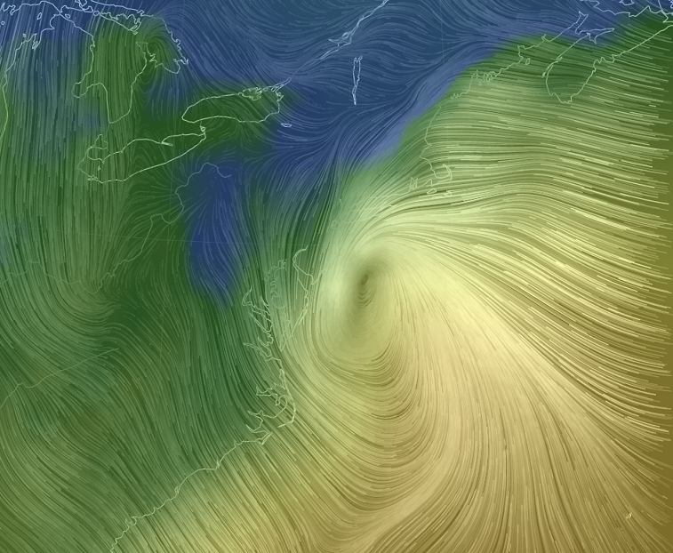
[Surface wind map of the coastal storm; courtesy "earth.nullschool.net"]

Discussion

Heavy rain continues at this hour across the New York City metro region and there is serious flooding all along coastal New Jersey. The next phase of this major coastal storm will begin early tonight as the surface low - now off the southern NJ coastline - stalls out in its northward advance near Long Island or southern New England. In this next phase, colder air in the mid and upper levels of the atmosphere will “wrap-around” the surface system into its southwest quadrant and this will increase the chances for “back end” snow showers later tonight, tomorrow and tomorrow night across much of the Mid-Atlantic region including eastern Pennsylvania and then right into the day on Thursday. The “wrap-around” snow showers can reach as far south as the DC metro region over the next 48 hours or so, but they will likely be much more numerous north of the PA/MD border.

sat 
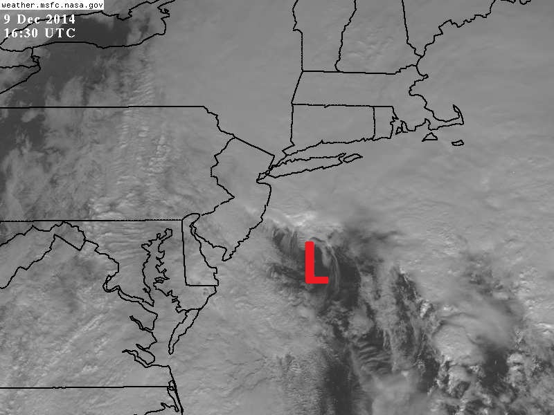
[11:30 AM visible satellite image with surface low pressure situated off the southern NJ coastline; courtesy NASA]

Slick spots on the roadways and small accumulations are likely from "wrap-around" snow shower activity during this next phase of the storm across much of the Mid-Atlantic region. Also, there is the chance for embedded heavier snow bands to form in the unstable atmosphere and, if this happens, they would likely produce heavy snowfall amounts in a short period of time over a given area. The "wrap-around" of the colder air into the NYC metro region will be delayed some due to the positioning of the surface low pressure system to the north. Precipitation there early tomorrow will likely remain primarily in the form of plain rain, but then snow showers will threaten in NYC from later tomorrow through tomorrow night. By Thursday, even though the low pressure system will weaken as it spins over the Northeast US, the threat for snow showers will indeed continue in this long-duration event all the way along the I-95 corridor from DC-to-Philly-to-NYC.

Stay tuned...the potential for small-scale "banding" during this next phase makes this a tricky and dynamic forecast.

12:30 PM | **The latest on the developing major coastal storm**

Paul Dorian

GFS_total_snowfall
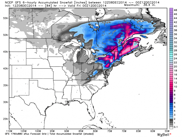
[12Z GFS "total snowfall" forecast map for the entire upcoming event]

Discussion

Overview A major storm will ride slowly up the coast over the next few days and it will bring nasty weather to much of the Northeast US ranging from heavy rain and strong winds in coastal regions to significant, accumulating heavy, wet snow in higher elevation inland locations. A dome of strong high pressure extending from the Northern Plains to eastern Canada will inhibit this developing coastal storm from moving northward and this will lead to a prolonged period of heavy precipitation throughout much of the Northeast US. In fact, in somewhat the same manner as Tropical Storm Agnes in June 1972, this storm is likely to stall out or take a loop on Tuesday night after it reaches the latitude of Long Island or southern New England as its northward progress will be stymied by stubborn blocking high pressure.

Today An area of "ocean-effect" light precipitation has continued to move inland from the Atlantic in the past couple of hours thanks to persistent NE winds on the eastern side of strong high pressure situated to our north. As a result, don't be surprised to see a little snow, sleet or rain during the next few hours - well ahead of any direct effects from the still-developing coastal storm. “Ocean-effect” snow is very similar to the more well-known “lake-effect” snow phenomenon that typically occurs over the Great Lakes when low-level winds pick up moisture over a large body of water and deposit it just inland.

Tonight and Tomorrow The developing coastal storm will produce steadier and heavier precipitation beginning later this evening in the DC area, near midnight across SE PA, and then late tonight in the NYC metro region. At the onset of the main precipitation event tonight, there can be some snow, sleet and/or freezing rain in suburban locations N and W of the big cities and slick spots can quickly form with small accumulations. The air mass in place is quite cold and dry and will only grudgingly retreat in the overnight hours as it is anchored by strong high pressure - always a key player in any snow event in the Northeast US. By tomorrow, however, as high pressure finally retreats from northern New England, the bulk of the precipitation should fall as plain rain, heavy at times, in the I-95 corridor region from DC-to-Philly-to-NYC with 1-3 inches likely by tomorrow night (the lower amounts to the southwest and the higher amounts to the northeast). Coastal sections from New Jersey to southern New England will experience wind gusts of 50mph or more during the height of the storm on Tuesday and Tuesday night. In addition, coastal flooding will be a real concern at times of high tide in those areas. Meanwhile, the greatest threat for heavy accumulating snow will extend from higher terrain locations of upstate Pennsylvania to interior sections of northern New England.

Euro_storm_track_with_loop 
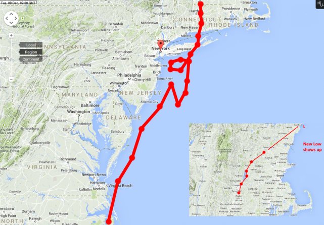
[12Z Euro storm track with the "loop"]

Tuesday night into Thursday Colder air will tend to wrap around the storm once it stalls out (and perhaps takes a loop, middle) in southern New England later tomorrow night/early Wednesday. This "wrap-around" colder air will increase the chances for steady snow or snow showers in the I-95 corridor region from DC-to-Philly-to-NYC during this “back end of the storm” phase from tomorrow night into Thursday. It is certainly within the realm of possibility that snow accumulations occur with slick spots on the roadways during this "back end" phase of the storm; especially, in suburban locations to the N and W of the I-95 corridor region between Philly and NYC. The atmosphere will remain unstable in the Northeast US as late as Thursday afternoon in this long-duration event with an impressive upper-level low spinning overhead (GFS 500 mb forecast map shown below for Thursday morning). This instability in the atmosphere will lead to "dynamic" snow shower activity on Wednesday and Thursday in the I-95 corridor and a few heavier snow squalls are possible at times. One final note, the 12Z GFS computer forecast model has caught up with other models and is now generating a strong coastal storm. The 12Z GFS “total snow accumulation” forecast map (top) for this entire upcoming event depicts the greatest amounts across interior locations of the Northeast US.

Stay tuned, this storm is certainly not set in stone yet.

GFS_500mb_Thu_AM_12Zrun 
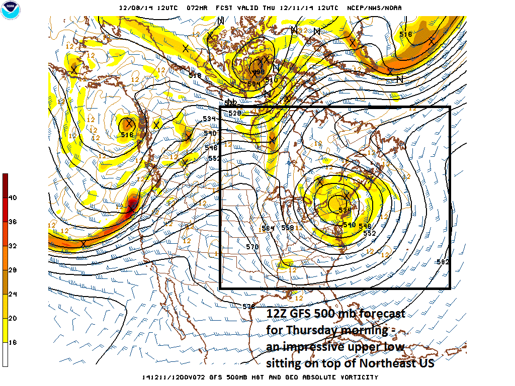
[12Z GFS 500 mb forecast map for Thursday morning]

Video

httpv://youtu.be/EPlzQ9515O0

7:00 AM | **A major and long-duration coastal storm will pound much of the Northeast US over the next few days**

Paul Dorian

6-Day Forecast

Today

Thickening clouds, cold, a little light snow, sleet and/or rain possible at times, in the mid-to-upper 30’s

Tonight

Cloudy with steady rain developing, likely freezing on some surfaces N and W of the District, cold, lows in the low-to-mid 30's

Tuesday

Cloudy and breezy with periods of rain, low-to-mid 40’s

Tuesday Night

Cloudy and windy with chance for rain, possibly mixing with sleet and/or snow at times late in areas N and W of the District, cold, low-to-mid 30’s

Wednesday

Mostly cloudy with the chance for rain and/or snow showers, perhaps even a heavier snow squall, windy, cold, near 40 degrees

Thursday

Variable clouds, breezy, cold, snow showers still possible, near 40 degrees

Friday

Mostly sunny, cold, low-to-mid 40’s

Saturday

Mostly sunny, not as cold, near 50 degrees

Discussion

A major storm will ride slowly up the coast over the next few days and it will bring nasty weather to much of the northeast part of the country ranging from heavy rain and wind in coastal areas to significant, accumulating snow in inland, higher elevation locations. A dome of high pressure extending from the Northern Plains to eastern Canada will inhibit this developing coastal storm from moving quickly up the coastline and this will lead to a prolonged period of heavy precipitation throughout much of the Northeast US. In fact, the storm is likely to stall out or even take a loop after it reaches the Long Island or southern New England region Tuesday night as it's movement will be stymied by stubborn high pressure.

An area of "ocean-effect" light precipitation has broken out across southern New Jersey in the last couple of hours thanks to persistent NE winds. As a result, don't be surprised to see a little rain, sleet or snow during the next few hours well ahead of any effects from the now unfolding coastal storm. This light precipitation is moving inland with low-level wind flow from the northeast to the southwest. The heaviest rainfall from this impending storm will likely fall to our northeast from Philly-to-NYC; however, an inch or more is possible in throughout the DC metro region. The best chance for significant snowfall accumulations will extend from the mountains of northeastern Pennsylvania to interior New England where more than a foot can easily fall by early Wednesday. Our best chance for any frozen precipitation from the coastal storm - in addition to any light stuff that falls today from the "ocean-effect" - will occur at the onset of the steadier precipitation event tonight N and W of the District with potential freezing rain and then on the back side of the storm from late Tuesday night into Thursday when snow showers can develop and perhaps even a heavier snow squall or two. Coastal sections from the Delmarva Peninsula to Long Island could see winds gusting past 50 mph during the height of this major nor’easter on Tuesday with coastal flooding an additional concern.

Video

httpv://youtu.be/EPlzQ9515O0

12:30 PM | **Major coastal storm threat continues for next week...GFS computer forecast model slowly coming around**

Paul Dorian

500mb comparison
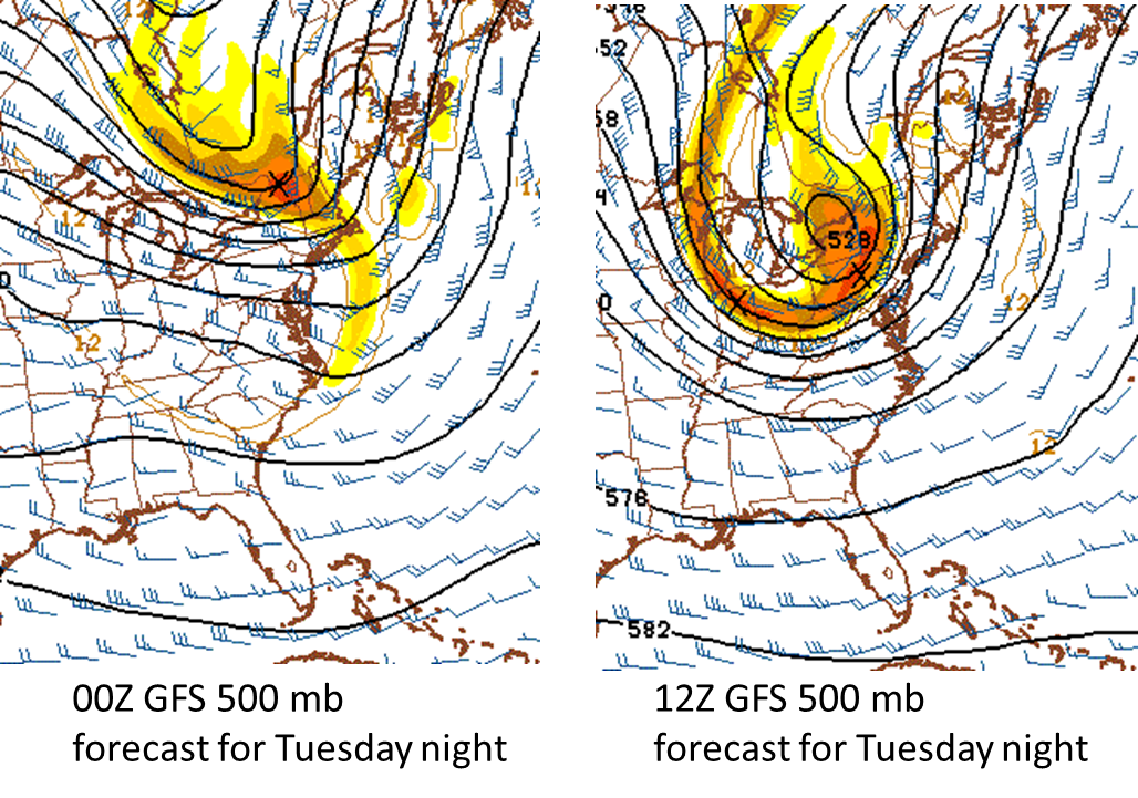
[Big changes at 500 mb between last night's GFS model run and this morning's run (verification time Tuesday night)]

Discussion

Overview The signs continue for a major coastal storm next week and while NOAA’s GFS computer forecast model continues to seemingly underplay this potential threat, it has made some important strides at a more robust solution in line with most other computer forecast models. Indications are that the 500 millibar upper-level pattern will feature blocking high pressure extending from the Northern Plains into southeastern Canada by early next week at the same time upper-level troughing will be digging into the Southeast US. The additional element of a strong upper-level jet streak early next week raises the chances of important intensification of surface low pressure off the coast in the “late Monday/Tuesday” time frame. There will likely also be cold air sitting across New England and southeastern Canada anchored by strong surface high pressure. It is still way too early to know where the rain/snow line would set up for this potential storm in the Northeast US, but odds would favor rain at or near the coastline perhaps with strong winds and coastal flooding, snows in the interior higher elevation locations, and perhaps quite a "battle zone" between rain and snow just to the north and west of Route I-95.

GFS computer forecast model There continue to be some big disagreements amongst the worldwide computer model forecasts, but the NOAA GFS computer forecast model - an outlier so far with a much weaker storm solution - has made some notable changes in its upper-level forecasts for next week that could signal big changes at the surface-level in the next couple of days. Specifically, the 500 and 250 millibar forecasts have changed noticeably for the same verification time (next Tuesday night) between last night’s 00Z model run and this morning’s just 12 hours later (12Z). The all-important upper-level trough of low pressure and associated jet streak are now much more aggressive on the latest GFS model run for next Tuesday night and more conducive to amplification. These upper-level forecast changes likely foretell a coming change at the surface-level by the GFS model in coming days with a much more intense coastal storm - and in line with numerous other forecast models. Stay tuned - someone in the interior Northeast US is liable to get walloped by snow from this storm.

250mb comparison 
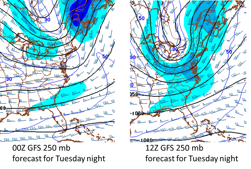
[Big changes at 250 mb between last night's GFS model run and this morning's run (verification time Tuesday night)]

Paul Dorian/Meteorologist VencoreWeather.com now on Facebook, Twitter and liveweatherblogs.com paul.b.dorian@vencore.com

7:00 AM | An occasional rain shower today can start briefly as a mix with sleet well to the N and W; periods of rain tonight and Saturday; coastal storm threat next week

Paul Dorian

6-Day Forecast

Today

Mostly cloudy, cold, occasional rain showers are possible at anytime and there can be some sleet mixed in briefly at the onset well to the N and W of the District, highs in the low-to-mid 40’s

Tonight

Cloudy with periods of rain, cold, temperatures holding nearly steady at around 40 degrees

Saturday

Cloudy with periods of rain, chilly, low 50's

Saturday Night

Cloudy with lingering rain in the evening, turning colder late, mid 30’s

Sunday

Partly sunny, windy, cold, mid 40’s

Monday

Increasing clouds, cold, chance for rain late, low-to-mid 40’s

Tuesday

Cloudy, breezy, cold, chance for rain and/or snow, low 40’s

Wednesday

Mostly cloudy, breezy, cold, still the chance for rain and/or snow, low 40’s

Discussion

High pressure will slide off the northern New England coastline today and this will allow moisture to advance into our region from the southwest. While there can be a few rain showers early today, the heaviest and steadiest rainfall during this next precipitation event will hold off until late today, tonight and Saturday. Also, as the initial rain showers move into the region this morning, it may be just cold enough at the start for some sleet to mix in at times in suburban locations well to the N and W of the District. Behind the system on Sunday, clearing skies will take place with a chilly wind, and it’ll stay colder-than-normal for this time of year. After that, attention will turn to the coastline for the possibility of a strong storm to form in the "late Monday/Tuesday/early Wednesday" time frame.

Video

httpv://youtu.be/oX4RvX2Ghx0

3:50 PM | *Potential continues for strong storm in the Northeast US early next week*

Paul Dorian

GEM_sfc_Tues_AM[12Z Canadian surface forecast map for next Tuesday morning; map courtesy tropicaltidbits.com]

Discussion

The signs continue for a significant storm during the first half of next week in the Northeast US. Indications are that the 500 millibar upper-level pattern will feature blocking high pressure extending from the Northern Plains into southeastern Canada by early next week at the same time upper-level troughing will be digging into the Southeast US. The additional element of a strong upper-level jet streak (bottom) across the southern states early next week raises the chances of important intensification of surface low pressure off the coast in the late Monday/Tuesday/early Wednesday time frame. There will likely be some well-entrenched cold air sitting across New England and southeastern Canada at this time anchored by strong surface high pressure. It is still too early to tell if this pattern will result in a “New York City/New England” type of storm or if it could have an important impact farther south along the I-95 corridor and it is still too early to tell if snow will be confined to interior sections of the Northeast US.

GFS_sfc_Tues_AM 
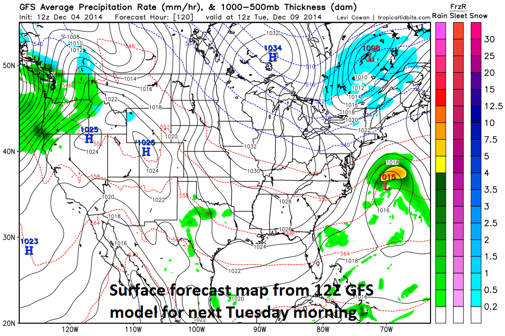
[12Z GFS surface forecast map for next Tuesday morning; map courtesy tropicaltidbits.com]

There continue to be some big disagreements amongst the worldwide computer models; however, NOAA’s GFS is pretty much an outlier at this point in time with a rather innocuous-looking forecast as compared with other computer forecast models including the Canadian, Euro, and UKMET (United Kingdom). The surface forecast maps which verify next Tuesday morning (top, middle) show big differences between the latest GFS and Canadian computer forecast models (maps courtesy tropicaltidbits.com). The 250 millibar 12Z Canadian model forecast for next Tuesday morning (bottom) displays a strong upper-level jet streak (circled area) that could play a vital role in the potential formation of a strong storm. Stay tuned, the overall weather pattern favors the Canadian, Euro and UKMET model forecast solutions and perhaps the GFS will change significantly over the next few days.

GEM_500mb_Tues_AM 
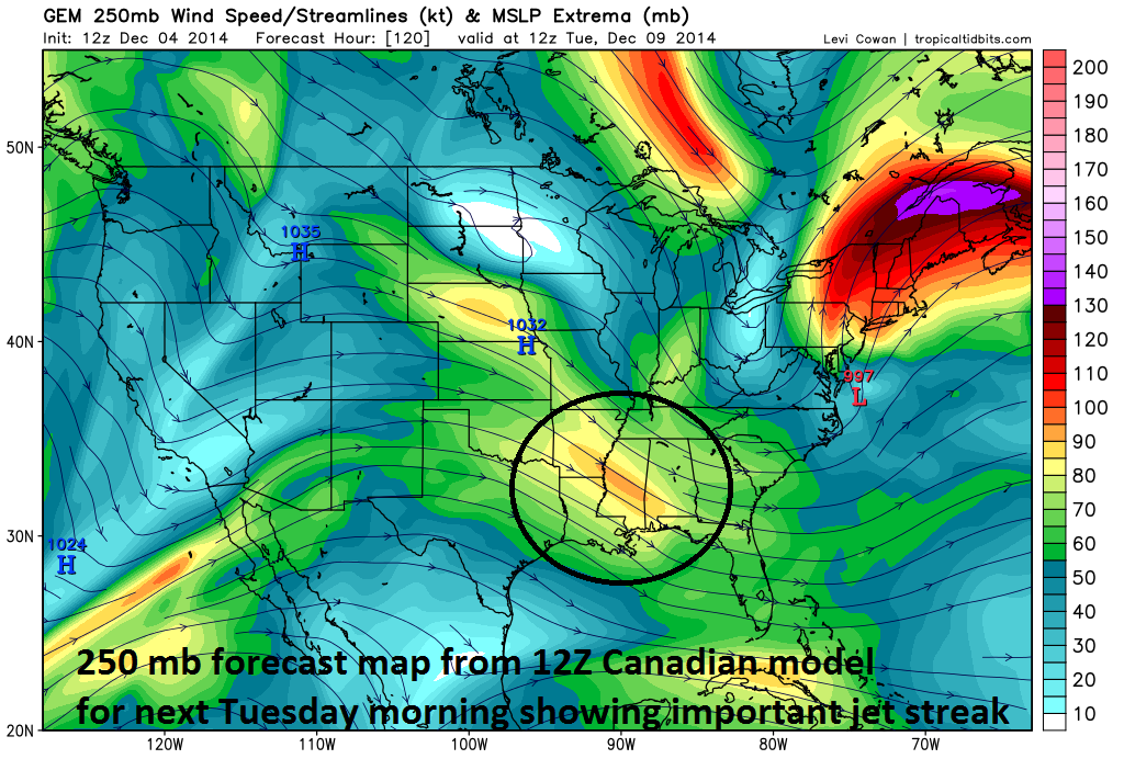
[12Z Canadian 250 millibar forecast map for next Tuesday morning; map courtesy tropicaltidbits.com]

7:00 AM | Active pattern with more rain coming tomorrow and Saturday; sleet could mix in with the rain at the onset on Friday to the N and W

Paul Dorian

6-Day Forecast

Today

Partly sunny, cold, highs in the low-to-mid 40’s

Tonight

Mostly cloudy, cold, lows in the lower 30’s

Friday

Mostly cloudy, cold, rain showers are possible and there can be some sleet mixed in at the onset, near 40 degrees

Friday Night

Cloudy with periods of rain, cold, upper 30’s

Saturday

Cloudy with periods of rain, chilly, upper 40’s

Sunday

Sun followed by clouds, cold, low 40’s

Monday

Mostly cloudy, cold, chance for rain or snow, low 40’s

Tuesday

Mostly cloudy, cold, chance for rain, low-to-mid 40’s

Discussion

The sun will try to make an appearance today, but no matter how much sunshine we get, temperatures will be confined to below normal levels for early December. Unfortunately, the sun will go back into hiding for the next couple of days as abundant moisture heads in our direction from the southwest. A few rain showers are possible during the day on Friday and it is possible that some sleet mixes in at the onset of this next event. The heaviest and steadiest rainfall from this next system is likely to occur tomorrow night and through much of the day on Saturday. Skies may then clear for a time on Sunday allowing for the return of some sunshine, but then clouds could return early next week depending on the track of a potential coastal storm.

Video

httpv://youtu.be/xMV8Ph_aD5s

4:30 PM | Potential Northeast US storm early next week

Paul Dorian

Euro_500mb_Tues_AM
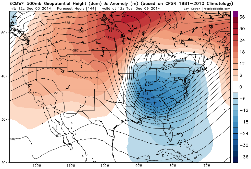
[12Z Euro 500 mb forecast map for next Tuesday morning; courtesy tropicaltidbits.com]

Discussion

The North America 500 millibar upper air pattern is likely to evolve over the next several days to become quite favorable for the development of a strong storm near the Northeast US coastline early next week. Strong upper-level (blocking) high pressure is likely to extend from the Northern Plains to southeastern Canada by early next week at the same time an upper-level trough of low pressure is digging into the Southeast US. This type of pattern should allow for the intensification of surface low pressure off the east coast early next week at the same time cold air builds up across New England and southeastern Canada anchored by strong surface high pressure. It is way too early to tell if this will result in a “New York City/New England” type of storm or if it could have an impact farther south along the I-95 corridor. Also, it is too early to tell if the threat for anything frozen will be confined to interior Northeast US locations only.

GEM_500mb_Tues_AM 
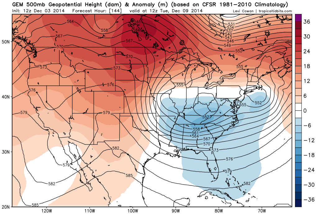
[12Z GEM 500 mb forecast map for next Tuesday morning; courtesy tropicaltidbits.com]

There currently is much disagreement amongst the many computer forecast models and that can be easily seen by comparing the 500 millibar forecast maps for next Tuesday morning from each of three models. The European and Canadian models (top, middle) generally agree with each other at 500 millibars and both feature impressive and digging troughs of low pressure into the southeastern US (blue) with blocking high pressure extending across the northern states into southeastern Canada (red). Meanwhile, the GFS operational model forecast (below) has a fairly unimpressive upper level trough in the same time period. Stay tuned, the overall weather pattern favors the Euro and Canadian model forecast solutions.

GFS_500mb_Tues_AM 
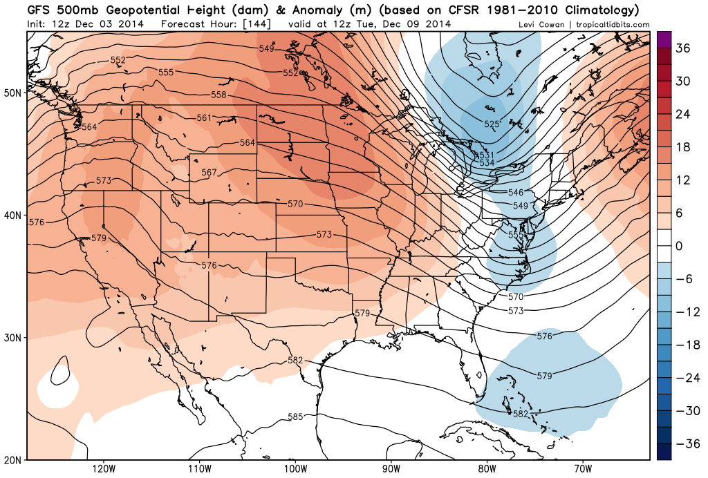
[12Z GFS 500 mb forecast map for next Tuesday morning; courtesy tropicaltidbits.com]

Paul Dorian/Meteorologist VencoreWeather.com now on Facebook, Twitter and liveweatherblogs.com paul.b.dorian@vencore.com

7:00 AM | Milder today, but then another cold shot arrives for tomorrow and Friday; more rain coming for Friday night and Saturday

Paul Dorian

6-Day Forecast

Today

Mostly cloudy, milder than yesterday, a touch of drizzle from time-to-time and some patchy fog, highs not far from 55 degrees

Tonight

Gradual clearing, turning colder, becoming breezy, lows in the low-to-mid 30’s

Thursday

Mostly sunny, colder, mid-to-upper 40’s

Thursday Night

Mostly cloudy, cold, maybe a bit of rain or sleet late, near 30 degrees

Friday

Mostly cloudy, cold, chance for a few rain showers during the day, rain is likely at night, low-to-mid 40’s

Saturday

Cloudy with periods of rain, chilly, near 50 degrees

Sunday

Becoming partly sunny, breezy, chilly, upper 40’s

Monday

Mostly cloudy, chilly, chance for rain, near 50 degrees

Discussion

Warmer air pushing in from the south has succeeded in eroding some of our cold low-level air that was entrenched in the region on Tuesday and the end result will be a milder day throughout the Mid-Atlantic region, but it will remain quite damp with some drizzle and fog. A strong cold front, however, will pass through the region tonight and it will usher in colder air for tomorrow and Friday. Another round of rain is likely to move back into our region for Friday night and Saturday and genuine clearing will have to wait until Sunday.

Video

httpv://youtu.be/zCoDOitIYY8

7:00 AM | A wintry mix today well north and west of the District can cause some slippery travel conditions

Paul Dorian

6-Day Forecast

Today

Mostly cloudy, much colder than yesterday, a wintry mix of rain and sleet likely at times well north and west of DC, a cold rain in the District, highs in the mid-to-upper 30’s

Tonight

Mostly cloudy, cold, any mixed precipitation this evening will become plain rain later tonight as temperatures gradually rise, patchy fog may also form late

Wednesday

Mostly cloudy, milder, chance for rain showers, mid 50’s

Wednesday Night

Mostly cloudy, cold, upper 30’s

Thursday

Partly sunny, colder, mid-to-upper 40’s

Friday

Mostly cloudy, cold, a wintry mix of rain, sleet and/or snow possible, low-to-mid 40’s

Saturday

Mostly cloudy, chilly, chance for rain showers, upper 40’s

Sunday

Mostly cloudy, chilly, chance for more rain showers, low 50’s

Discussion

A strong cold front passed through the region last night and much colder low-level air has funneled into the area from the northeast. This cold air mass is anchored by strong high pressure to our north and as warmer air tries to push northward later today, a wintry mix of rain and sleet is likely to break out and it can even cause some slippery travel conditions in suburban locations well to the north and west of the District. Temperatures in the overnight hours will actually rise gradually so that any mixed precipitation early this evening in suburban locations will likely become plain rain later this evening and some patchy fog may form as well. After a milder day on Wednesday, another cold front will usher in colder air for Thursday and Friday and we could have a repeat performance of today to close out the work week with more mixed precipitation possible on Friday. Elsewhere, drought-stricken California will get a deluge over the next few days with up to 6 inches of rainfall in many locations ranging from southern-to-northern sections of the state.

Video

httpv://youtu.be/3IzR3JhRwk4