Contact Us

Use the form on the right to contact us.

You can edit the text in this area, and change where the contact form on the right submits to, by entering edit mode using the modes on the bottom right. 


123 Street Avenue, City Town, 99999

(123) 555-6789

email@address.com


You can set your address, phone number, email and site description in the settings tab.
Link to read me page with more information.

backlit-stratus-clouds-2013-04-05.jpg

Blog

Weather forecasting and analysis, space and historic events, climate information

Filtering by Category: DC

7:00 AM | Chilly today and Friday...weekend looking rather quiet...next week looking very noisy

Paul Dorian

6-Day Forecast

Today

Partly-to-mostly sunny, breezy, cold, highs in the lower 40’s

Tonight

Mostly cloudy, cold, lows by morning in the upper 20’s

Friday

Mostly sunny, cold, low-to-mid 40’s

Friday Night

Partly cloudy, cold, upper 20's

Saturday

Partly sunny, cold, cannot rule out a rain or snow shower at night, low 40's

Sunday

Partly sunny, cold, cannot rule out a rain or snow shower, low 40's

Monday

Mostly cloudy, cold, rain likely, low 40’s

Tuesday

Mostly cloudy, not as cold, still the chance for some rain, upper 40’s

Discussion

Colder air has returned to the region following the passage of a frontal system early yesterday. Today and Friday will be slightly colder-than-normal in the Mid-Atlantic region, but dry on each day along with limited sunshine. Over the weekend, low pressure will pull out of the southern states and head towards the Mid-Atlantic coastline. It appears that intensification of this system at the coastline will be quite limited and that its precipitation field will generally stay southeast of the I-95 corridor.

The overall weather pattern looks very active next week as the atmosphere over North America undergoes some significant changes. One storm could ride up the east coast on Monday bringing a soaking rain event to the I-95 corridor and then another and even stronger storm is likely to affect the Northeast US and Upper Midwest by Christmas Eve (Wednesday). Odds favor rain in the I-95 corridor with the second storm and it could be another soaking rain event possibly even including some thunderstorm activity. On the back side of that mid-week storm, winds could howl next Wednesday night and again on Christmas Day and there will likely be a significant temperature plunge. The overall pattern looks to get progressively colder as we move from Christmas Day to New Year's Day.

Video

httpv://youtu.be/VFKDo5D-Sw4

7:00 AM | Cold front ushers in colder air for tonight, tomorrow and Friday...weekend storm looks rather weak, but still time for that to change

Paul Dorian

6-Day Forecast

Today

Mostly sunny, becoming quite breezy, cool, highs not far from 50 degrees

Tonight

Partly cloudy, breezy, turning noticeably colder late, lows by morning near 30 degrees

Thursday

Mostly sunny, breezy, cold, low-to-mid 40’s

Thursday Night

Partly cloudy, cold, upper 20’s

Friday

Mostly sunny, cold, low-to-mid 40’s

Saturday

Becoming mostly cloudy, cold, chance for rain and/or snow late, near 40 degrees

Sunday

Mostly cloudy, cold, chance for rain and/or snow early, near 40 degrees

Monday

Mostly cloudy, cold, maybe some rain and/or snow shower activity, near 40 degrees

Discussion

A warm front pushed through the region on Tuesday and a cold front has followed closely on its heels. After a relatively mild day today with highs at or slightly above 50 degrees, colder air will become noticeable tonight and then the next two days will return to colder-than-normal conditions. The weekend will feature low pressure moving from the southern states towards the Mid-Atlantic coastline. The main disturbance involved with this potential Mid-Atlantic storm is just now moving onshore in California. Latest indications are that this system will remain rather weak this weekend and that any potential precipitation event around here would be only of the "light-to-moderate" variety; however, there is still time and reason to believe that this can change. There is some hinting that an inverted trough of low pressure will try to throw additional rain/snow shower activity our way on Monday and then a stronger storm is possible on Christmas Eve (next Wednesday). As of now, odds favor rain from that mid-week storm in the Mid-Atlantic region and then it would likely set up a cold pattern around here for the week between Christmas Day and New Year's Day. Stay tuned...an active pattern setting up with a lot going on over the next 7-10 days.

Video

httpv://youtu.be/EIY3X_TU858

7:00 AM | Warm frontal rainfall today...cold front crosses the region tomorrow...colder late this week and then a weekend storm threat

Paul Dorian

6-Day Forecast

Today

Mostly cloudy with patchy fog this morning and then mid-day and afternoon showers which can come down hard for a brief time, cool, highs near 50 degrees

Tonight

Mostly cloudy, chilly, lows near 40 degrees

Wednesday

Partly sunny, breezy, cool, near 50 degrees

Wednesday Night

Partly cloudy, turning colder, upper 20’s

Thursday

Mostly sunny, colder, low 40’s

Friday

Mostly sunny, cold, low 40's

Saturday

Mostly cloudy, cold, chance for rain or snow late, upper 30’s

Sunday

Mostly cloudy, cold, chance for rain or snow, mid-to-upper 30’s

Discussion

A warm front will push through the region later today causing mid-day and afternoon showers and slightly milder conditions. The rain can fall heavily for a brief time during the mid-day and early afternoon hours. A cold front will then follow closely on its heel by early tomorrow and this will generate a downward trend in temperatures as we progress from mid-to-late week. Attention turns towards the east coast this weekend as a storm should pull out of the south and amplify near the Mid-Atlantic coastline. This potential weekend storm may very well signal the start of a "colder and stormier" weather pattern that could last through the remainder of December and right into the New Year.

Video

httpv://youtu.be/4A9pNHlGy94

7:00 AM | Showers and milder on Tuesday; colder by Thursday following cold frontal passage; weekend storm threat

Paul Dorian

6-Day Forecast

Today

Mostly cloudy this morning, partly sunny this afternoon, cool, highs in the upper 40's

Tonight

Mostly cloudy, chilly, patchy fog possible late, lows in the mid 30’s

Tuesday

Mostly cloudy, cool, chance for showers, near 50 degrees

Tuesday Night

Mostly cloudy, chilly, chance for showers early, upper 30’s

Wednesday

Partly sunny, cool, near 50 degrees

Thursday

Mostly sunny, colder, low-to-mid 40’s

Friday

Mostly sunny, cold, low-to-mid 40’s

Saturday

Mostly cloudy, chilly, chance for rain or snow, upper 30's

Discussion

A stubborn deck of stratocumulus clouds persists this morning in much of the Mid-Atlantic region and it won't allow for much sunshine until possibly later this afternoon (heard that before). The combination of an inversion in the atmosphere (increasing temperatures with height) and the low sun angle this time of year will continue to keep it cloudy - for at least part of the day - in much the same way as the same atmospheric conditions did last week over the Grand Canyon in Arizona. A warm front is likely to spread showers into the region on Tuesday and temperatures will climb a bit compared to today and then that will be quickly followed by a cold frontal passage early on Wednesday.

Looking ahead, the relatively calm conditions over the next five days look like they’ll give way to a stormier weather pattern beginning this weekend and perhaps continuing right through the rest of December. One storm may threaten the Mid-Atlantic region this weekend with rain or snow and then there may be another one to deal with by Wednesday or Thursday of next week and then another one a few days after that.

Video

httpv://youtu.be/8-iEawLH8Yc

7:00 AM | Calmer weather returns to the region as stubborn low finally relinquishes control to building high pressure; Geminid meteor shower this weekend

Paul Dorian

6-Day Forecast

Today

Becoming partly sunny, breezy, cold, highs in the low 40’s

Tonight

Partly cloudy, cold, lows in the upper 20's

Saturday

Mostly sunny, chilly, mid 40’s

Saturday Night

Partly cloudy, cold, near 30 degrees for lows

Sunday

Mostly sunny, chilly, near 50 degrees

Monday

Mostly sunny, chilly, near 50 degrees

Tuesday

Mostly cloudy, chilly, chance for a few showers, near 50 degrees

Wednesday

Partly sunny, a bit colder, mid-to-upper 40’s

Discussion

The stubborn low pressure system that spun around to our north over the past couple of days will finally give way today to building high pressure in the Mid-Atlantic region. As a result, our weather pattern will calm down for the next several days featuring dry conditions right into early next week along with a gradual warm up.

One other note...it is that time of year again for the Geminid meteor shower. Geminid meteor activity is picking now up as Earth moves deeper into the debris stream of rock comet 3200 Phaethon. Forecasters expect the shower to peak this weekend with as many as 120 meteors per hour. Wherever you live, the best time to look is during the hours between midnight and dawn on Saturday and Sunday.

Video

httpv://youtu.be/ynxOm-p2i_A

7:00 AM | *"Wrap-around" snow showers today primarily across northern sections of the DC metro region*

Paul Dorian

6-Day Forecast

Today

Considerable clouds, windy and cold, snow showers are likely; especially, across northern sections of the DC metro region, small accumulations possible, highs near 40 degrees

Tonight

Mostly cloudy, breezy and cold, lows in the upper 20’s

Friday

Partly sunny, cold, low 40’s

Friday Night

Partly cloudy, cold, near 30 degrees

Saturday

Mostly sunny, cold, mid 40’s

Sunday

Mostly sunny, chilly, upper 40’s

Monday

Mostly sunny, cool, near 50 degrees

Tuesday

Mostly cloudy, cool, chance for showers, near 50 degrees

Discussion

Persistent low pressure will remain over the Northeast US today and this will continue the windy conditions around here and snow showers cannot be ruled out; especially, for areas to the north and east of the District (e.g., Montgomery County) with small accumulations possible. "Wrap-around" snow showers indeed pin wheeled around stalled out low pressure yesterday and last night into areas north of the PA/MD border, and they will have a better chance at reaching this far south during the day on Thursday as the effects of the stationary storm "spread out". This stubborn low pressure system will finally relinquish to building high pressure on Friday and the weekend should turn out to be dry, calmer and chilly for this time year. Milder weather is likely early next week as high pressure continues to be the dominant player.

Video

httpv://youtu.be/tzqQMuR15i4

12:45 PM | *"Wrap-around" snow showers intensifying on radar*

Paul Dorian

radar[Latest radar image from Penn State Campus Weather Service]

Discussion

The major coastal storm that pushed slowly northward yesterday along the Mid-Atlantic coastline has stalled out over southern New England and colder air in the mid and upper atmosphere is “wrapping around” the surface low pressure system. At the same time, a little piece of upper-level energy (arrow) is rotating around the surface system from the Ohio Valley and this is strengthening the upper-level low at 500 mb which is creating very unstable conditions. As a result, snow showers are intensifying on radar across NE PA and NW, NJ and they will pivot southwestward into many of the northern and western suburbs of Philly over the next couple of hours and small accumulations are possible. There can even be a few heavier snow squalls mixed in the picture given the increasingly unstable environment.

Snow showers are already creating some problems in the NYC metro region with some reported accumulations, and the Poconos in NE, PA have experienced moderate-to-heavy snow bands in the past couple of hours. Most of the snow shower activity will remain north of the PA/MD border; however, a few snow showers can drop as far south as the northern suburbs of Washington, DC by later this evening and again on Thursday. This "wrap-around" snow shower threat will continue through the night in much of the Mid-Atlantic region with more small accumulations likely and some slick spots on the roadways; especially, north of the PA/MD border, and the threat will continue right through the day on Thursday. After that, the surface low pressure system will finally relinquish to high pressure on Friday and dry weather is likely during the upcoming weekend.

500 mb

7:00 AM | Lingering storm to bring windy conditions and snow or rain showers to region

Paul Dorian

500 mb

6-Day Forecast

Today

Considerable clouds, windy and cold with an isolated snow or rain shower, highs in the low-to-mid 40's

Tonight

Cloudy, windy and cold with an isolated snow shower or two possible; especially, across the northern suburbs, lows near 30 degrees

Thursday

Considerable clouds, still windy and cold, cannot rule out a few snow showers; especially, across northern sections of the District, near 40 degrees

Thursday Night

Cloudy, breezy, cold, near 30 degrees

Friday

Partly sunny, cold, low 40’s

Saturday

Mostly sunny, cold, mid 40’s

Sunday

Mostly sunny, chilly, near 50 degrees

Monday

Mostly sunny, chilly, near 50 degrees

Discussion

The major coastal storm that pushed slowly northward yesterday along the Mid-Atlantic coastline has stalled out over southern New England and colder air in the mid and upper atmosphere is “wrapping around” the surface low pressure system. At the same time, a little piece of upper-level energy (arrow) is rotating around the surface system from the Ohio Valley and this will act to reinvigorate the upper-level low today at 500 mb (see map) which will keep the atmosphere quite unstable. As a result, snow showers will threaten today across eastern PA and perhaps even into the northern sections of the District by later this evening and then again during the day Thursday. The surface low will finally relinquish to high pressure on Friday and dry weather is likely during the upcoming weekend.

Video

httpv://youtu.be/G_ldNYhrUyI

12:30 PM | **Next phase of the coastal storm to bring "wrap around" snow showers to much of the Mid-Atlantic region**

Paul Dorian

wind_map
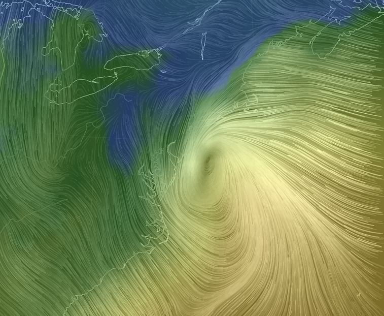
[Surface wind map of the coastal storm; courtesy "earth.nullschool.net"]

Discussion

Heavy rain continues at this hour across the New York City metro region and there is serious flooding all along coastal New Jersey. The next phase of this major coastal storm will begin early tonight as the surface low - now off the southern NJ coastline - stalls out in its northward advance near Long Island or southern New England. In this next phase, colder air in the mid and upper levels of the atmosphere will “wrap-around” the surface system into its southwest quadrant and this will increase the chances for “back end” snow showers later tonight, tomorrow and tomorrow night across much of the Mid-Atlantic region including eastern Pennsylvania and then right into the day on Thursday. The “wrap-around” snow showers can reach as far south as the DC metro region over the next 48 hours or so, but they will likely be much more numerous north of the PA/MD border.

sat 
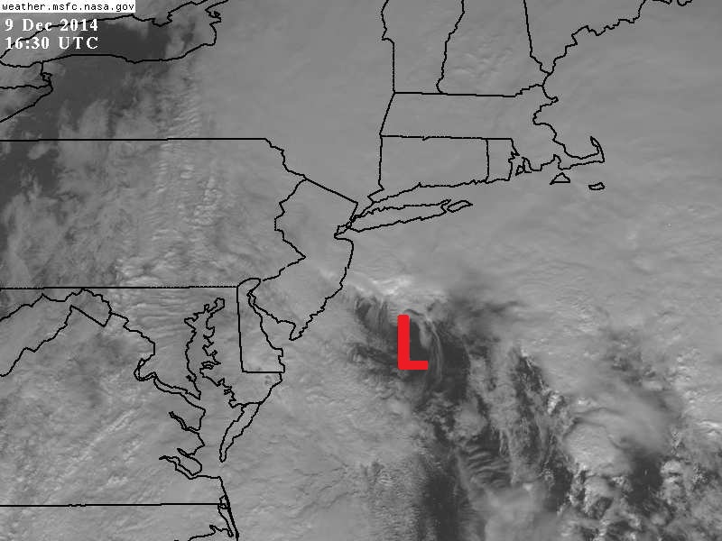
[11:30 AM visible satellite image with surface low pressure situated off the southern NJ coastline; courtesy NASA]

Slick spots on the roadways and small accumulations are likely from "wrap-around" snow shower activity during this next phase of the storm across much of the Mid-Atlantic region. Also, there is the chance for embedded heavier snow bands to form in the unstable atmosphere and, if this happens, they would likely produce heavy snowfall amounts in a short period of time over a given area. The "wrap-around" of the colder air into the NYC metro region will be delayed some due to the positioning of the surface low pressure system to the north. Precipitation there early tomorrow will likely remain primarily in the form of plain rain, but then snow showers will threaten in NYC from later tomorrow through tomorrow night. By Thursday, even though the low pressure system will weaken as it spins over the Northeast US, the threat for snow showers will indeed continue in this long-duration event all the way along the I-95 corridor from DC-to-Philly-to-NYC.

Stay tuned...the potential for small-scale "banding" during this next phase makes this a tricky and dynamic forecast.

7:00 AM | **Major coastal storm impacts the Mid-Atlantic region today ...colder air will wrap around the storm tonight raising the chances for snow showers in our region**

Paul Dorian

Euro_storm_track_with_loop
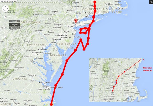
[Monday, 12Z European model storm track with the "loop"]

6-Day Forecast

Today

Cloudy, windy and cold with periods of rain, some freezing will continue early today to the N and W of the District, highs in the low 40’s

Tonight

Cloudy, windy and cold with rain possibly mixing with or changing to snow late to the N and W of the District, lows in the low-to-mid 30’s

Wednesday

Cloudy, windy and cold with snow showers, possibly mixed with rain at times, perhaps even a heavier snow squall, near 40 degrees

Wednesday Night

Cloudy and windy with snow showers still possible, may be mixed with rain at times, cold, near 30 degrees

Thursday

Mostly cloudy, windy, cold, another snow shower or two still possible, near 40 degrees

Friday

Partly sunny, breezy, cold, near 40 degrees

Saturday

Partly sunny, chilly, near 45 degrees

Sunday

Mostly sunny, not as chilly, near 50 degrees

Discussion

A major coastal storm will impact the Mid-Atlantic region today as it slowly moves up the coastline while intensifying. As it moves north into southern New England this evening, it will run into an “atmospheric road block” forcing the storm to stall out or even loop around ensuring a long-duration event for the Northeast US and more precipitation is likely around here from tonight through tomorrow night. The bulk of the precipitation today in the DC metro region should be in the form of plain rain, but as colder air wraps into the system later tonight, the rain can mix with or change over to snow, and snow showers threaten the area from later tonight through tomorrow night.

Video

httpv://youtu.be/opPhkN9ixcw