Contact Us

Use the form on the right to contact us.

You can edit the text in this area, and change where the contact form on the right submits to, by entering edit mode using the modes on the bottom right. 


123 Street Avenue, City Town, 99999

(123) 555-6789

email@address.com


You can set your address, phone number, email and site description in the settings tab.
Link to read me page with more information.

backlit-stratus-clouds-2013-04-05.jpg

Blog

Weather forecasting and analysis, space and historic events, climate information

Filtering by Category: DC

12:30 PM | **Interesting features on today’s visible satellite image and an update on the sneaky accumulating snow threat for tomorrow**

Paul Dorian

satellite
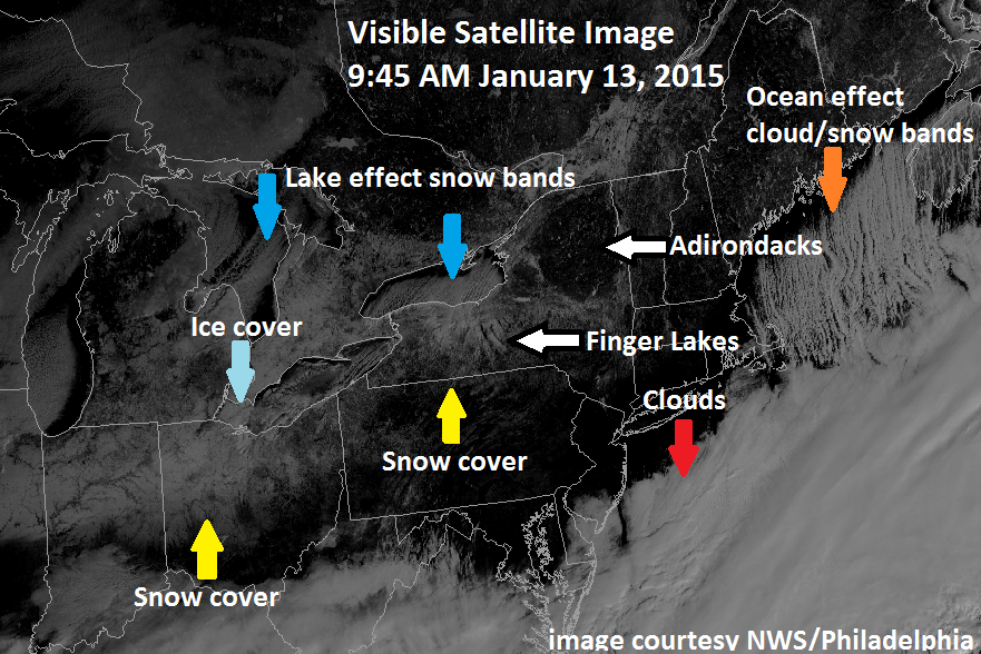
[Morning visible satellite image with numerous interesting features; courtesy National Weather Service/Philadelphia; NOAA]

Discussion

Visible satellite image and some interesting features Satellite images are extremely valuable in the world of weather forecasting and this morning’s GOES visible image has several interesting features in the Great Lakes region, Ohio Valley and Northeast US. First, clear skies exist in the I-95 corridor region from DC-to-Philly-to-NYC and these cloud-free conditions should last into the early part of tonight allowing for the possibility of viewing Comet Lovejoy (see posting at http://vencoreweather.com/2015/01/13/1050-am-an-update-on-comet-lovejoy-now-in-its-best-two-weeks/). However, thick clouds can be seen on the satellite image just to the south and east of DC and they will advance northward later tonight associated with an area of moisture that may produce some snow around here on Wednesday (see below). Elsewhere, snow cover can be seen across northern Indiana and northern Ohio as well as in New York State, and geographical features like the Finger Lakes and Adirondacks Mountains become quite noticeable with clear skies and surrounding snow cover.

In addition, a northerly wind is generating “lake-effect” snow bands that are dropping southward from Lake Ontario into western New York State and the same atmospheric pattern is generating cloud and snow bands just downwind of Maine (for more on the “lake-effect” snow phenomenon check out video #20 on our Meteo 101 page: http://vencoreweather.com/meteorology-101/). Finally, ice cover is starting to expand quite rapidly in the Great Lakes and given the current cloud-free skies, some of this is visible on today's visible satellite image over western Lake Erie (the shallowest of the Great Lakes which often freezes early). Let me add that the best way to confirm that these surface features are real (ice cover, snow cover, etc.) is to look at a loop of visible satellite images which can be done at the Penn State eWall web site: http://mp1.met.psu.edu/~fxg1/SAT_NE/anim8vis.html).

Sneaky snow threat for Wednesday in parts of the Mid-Atlantic region Accumulations of snow are on the table for parts of the Mid-Atlantic region on Wednesday; especially, in the region from the DC metro region-to-southern New Jersey and cutting across the Delmarva Peninsula where a coating to an inch or two can fall. Some light snow accumulations can even occur as far north and east as the Philly and NYC metro regions, but higher chances do exist just to the south and east of those areas. The combination of weak upper level energy, increasing low-level east-to-northeast flow off the Atlantic Ocean, and an area of moisture currently sitting over the Carolinas will likely generate some snow accumulations in parts of the Mid-Atlantic region late tonight and Wednesday - likely in time to have an impact on the DC morning commute. Sleet could mix in at times tomorrow to the south and east of DC and especially near coastal sections of New Jersey and the Delmarva Peninsula, but given the influx today of fresh cold, dry Arctic air, primarily snow should fall in and around DC (and in Philly and NYC if it makes it that far). Stay tuned on this as it is a tricky forecast.

nam_mslp_pcpn_frzn_us_9 
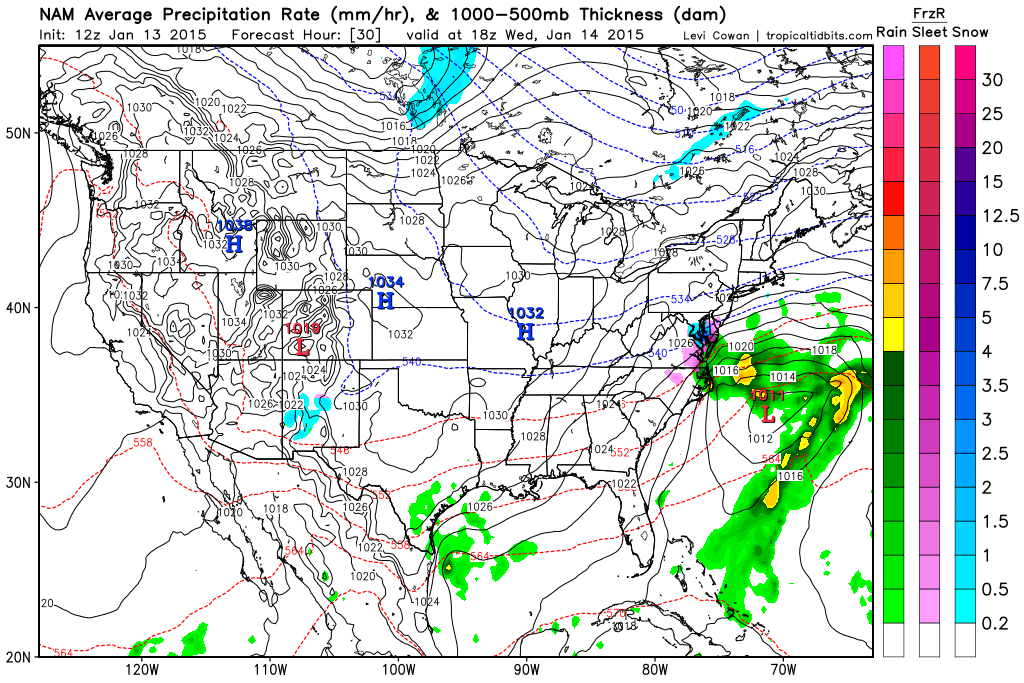
[12Z NAM forecast map for mid-day Wednesday (blue=snow, purple=sleet); courtesy "tropicaltidbits.com"]

2:45 PM | *Slippery "black ice" conditions possible late tonight into early Tuesday*

Paul Dorian

Discussion

The back edge of some steadier and heavier rainfall is now working its way through the I-95 corridor, but that does not mean this precipitation event is ending. A surface cold frontal system still resides to our west and there will be some light precipitation later today and tonight that will likely ultimately change from plain rain to ice and/or snow in many areas as colder air filters in from the northwest. The combination of light frozen precipitation and rapidly dropping temperatures late tonight could very well create slippery “black ice” conditions in the I-95 corridor that last into tomorrow morning. The frozen precipitation amounts in the overnight hours will likely be on the light side, but it doesn’t take much to cause problems on the roadways; especially, when combined with quickly dropping temperatures as yet another very cold air mass moves into the region. This very cold air mass will be anchored by strong Arctic high pressure on Tuesday edging eastward from the Northern Plains. Temperatures tomorrow afternoon will struggle to pass the 30 degree mark in many I-95 corridor locations and the teens are likely to be quite widespread tomorrow night. Watch for slippery spots later tonight into early Tuesday.

Video

httpv://youtu.be/EvZBfyl7X5M

6:00 AM | **Icing this morning will last longest in the far northern and western suburbs...plain rain likely throughout the metro region this afternoon**

Paul Dorian

6-Day Forecast

Today

Cloudy, cold, freezing rain continues well north and west of the District until late morning, plain rain likely throughout this afternoon, highs in the upper 30’s

Tonight

Cloudy, cold, rain could change briefly to ice and/or snow before ending, lows late tonight in the mid-to-upper 20's

Tuesday

Mostly cloudy, cold, near 30 degrees

Tuesday Night

Mostly cloudy, quite cold, low 20’s

Wednesday

Mostly cloudy, cold, chance for a little snow, near the freezing mark for highs

Thursday

Partly sunny, cold, mid-to-upper 30’s

Friday

Partly sunny, cold, upper 30’s

Saturday

Partly sunny, not as cold, low 40's

Discussion

Icing will continue over the next few hours in the far northern and western suburbs where surface temperatures hover near the freezing mark. Untreated surfaces (driveways, sidewalks) will stay especially icy in many areas until temperatures edge into the mid and upper 30's later today. Plain rain is likely throughout the area this afternoon, but as colder air filters back into the region tonight, the precipitation could change back briefly to ice and/or snow before ending. Quite cold conditions are in store for tomorrow and tomorrow night in the Mid-Atlantic region and then some moisture could move our way on Wednesday - perhaps creating a bit of snow around here. Longer term, milder weather is in store in the Mid-Atlantic for about a week or so beginning later this weekend; however, the cold pattern will resume later this month.

10:00 AM | **Significant icing event later tonight/Monday morning in northern and western suburbs**

Paul Dorian

nam_mslp_pcpn_frzn_us_6[12Z NAM forecast map for early Monday (green=rain, purple=ice, blue=snow); map courtesy "tropicaltidbits.com"]

Discussion

Overview The combination of increasing warmer air in the upper atmosphere, moisture advancing from the southwest, and the residual effects of the currently entrenched bitter cold Arctic air mass is setting the stage for a significant icing event late tonight and Monday morning; especially, to the north and west of the big cities from DC-to-Philly-to-NYC. The increase in clouds today is associated with an area of moisture in the southern part of the country that is heading in our direction. It appears that it’ll stay cold enough at low levels of the atmosphere late tonight and Monday morning for an extended period of icing in suburban locations of the big cities along I-95 and slippery spots are likely for the morning commute.

Details DC metro area Precipitation begins most likely in the form of freezing rain between 10pm and 1am; however, there can be sleet mixed in at times especially at the onset. Snow is unlikely here, and if it does occur, it will be for a very brief period of time only. The freezing rain will continue into the early morning hours in the District and immediate suburban locations and into the mid-to-late morning hours in the farther out northern and western suburbs (e.g. Frederick, Loudoun and Carroll counties) where there can be a buildup of ice on untreated surfaces. Slippery spots are possible on roadways for the morning commute throughout the region. All areas in the metro region should see plain rain during the afternoon.

Philly and NYC metro regions Precipitation likely begins as snow between 3 and 6am and it could produce small accumulations of snow before changing to sleet and/or freezing rain. The sleet and/or freezing rain will continue for an extended period of time and a significant build of ice is likely on untreated surfaces; especially, in the northern and western suburbs. Slippery spots will have an impact on the morning commute. The icing continues into the early afternoon hours in the northern and western suburbs before finally changing to plain rain later in the day. The precipitation may change back to ice and/or snow late tomorrow or early tomorrow night before ending as colder air filters back into the region.

Looking ahead The upcoming week generally looks quite cold and there are two other potential precipitation events. The first such event will take place Tuesday night/early Wednesday as moisture from the south could push into the area causing some snowfall. Late in the week, there is likely to be a storm near the southeast US coastline. Current indications are that this storm will move off-shore, but the overall pattern suggests it is still worth monitoring.

A temporary break in the cold pattern is likely to begin later next weekend, but January is still likely to end up as cold or even colder on a nationwide basis than last year in a winter that is likely to go on and on along with these occasional warmups.

12:40 PM | **More bitter cold and then a potential icy mess on Monday morning**

Paul Dorian

gfs_mslp_pcpn_frzn_us_12[12Z GFS forecast map for Monday morning (blues=snow; purple=ice); map courtesy "tropicaltidbits.com"]

Discussion

The last in a series of three “clipper” systems produced snow showers in much of the I-95 corridor this morning and there can be residual scattered snow showers this afternoon along with gusty winds. Temperatures will plunge tonight to bitter cold levels into the single digits in many locations and high temperatures on Saturday will again struggle to escape the teens. After another bitter cold night, Sunday will feature an increase in clouds as temperatures modify somewhat to more "normal" cold for this time of year. The increase in clouds on Sunday will be associated with an area of moisture in the south-central US that will head into our direction. This is a different pattern than the recent “clipper” systems which dropped southeastward from the Northern Plains and Upper Midwest into our region. It appears that it’ll likely be cold enough for a wintry mix to occur in much of the I-95 corridor by Monday morning. This wintry mix can certainly include freezing rain and/or sleet just in time to mess up the Monday morning commute. Stay tuned.

7:00 AM | **Weather pattern repeats for Friday and Saturday with more gusty winds tomorrow and a possible snow shower to be followed by more bitter cold air for Friday night/Saturday**

Paul Dorian

records_daily_usa
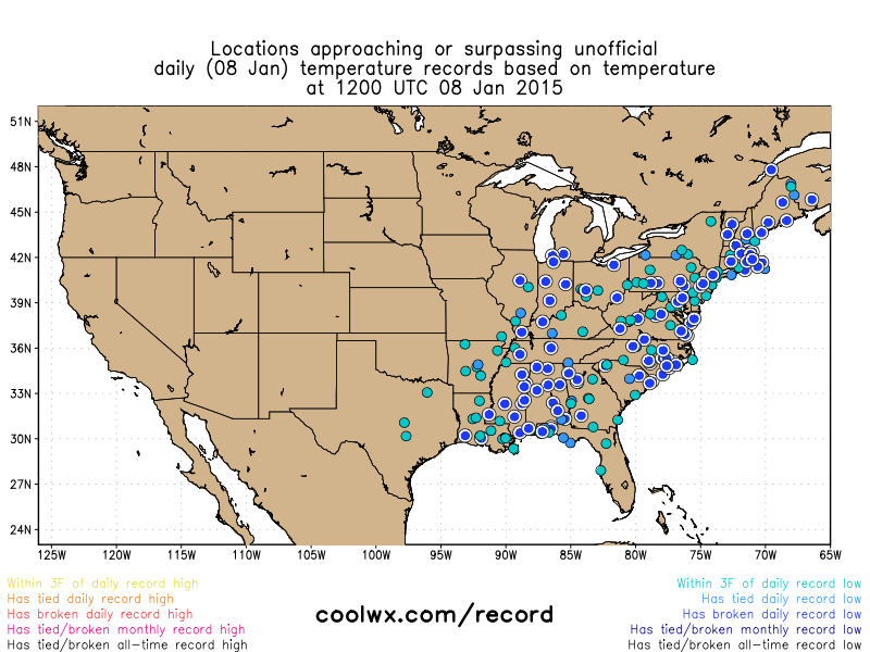
[Dozens of record or near record lows this morning (blue circles); map courtesy coolwx.com]

6-Day Forecast

Today

Mainly sunny, not as windy as yesterday, brutal cold, highs in the upper teens

Tonight

Increasing clouds, bitter cold, chance for a snow shower late, lows not far from 15 degrees

Friday

Partial sunshine, windy, still quite cold, but not as severe, chance for a snow shower or two, low 30’s

Friday Night

Mostly clear, brutal cold, near 10 degrees

Saturday

Mainly sunny, breezy, bitter cold, low 20’s

Sunday

Partly sunny, still quite cold, but not as severe, middle 30’s

Monday

Mostly cloudy, cold, chance for snow, ice or rain, mid-to-upper 30’s

Tuesday

Mostly cloudy, still quite cold, chance for snow, ice or rain, mid 30’s

Discussion

Single digits are widespread this morning in the Northeast US and temperatures will struggle around here today to reach the upper teens despite plenty of sunshine. This air mass is comparable to some of winter’s worst from last winter with dozens of record or near record lows this morning (map courtesy coolwx.com). A repeat performance is in store for the next couple of days with yet another “clipper” system bringing snow showers into the Northeast US on Friday along with gusty winds and then bitter cold air will follow for the beginning of the weekend. Temperatures ease somewhat on Sunday and then moisture pulling out of the southern states could affect us with some snow, ice or rain during the early part of next week.

12:30 PM | **Snow squalls, brutal cold and dangerous wind chills**

Paul Dorian

radar[Latest NEXRAD radar image; courtesy University of Wisconsin]

Discussion

The worst that winter has yet to offer this year is about to pounce on the Mid-Atlantic region with brutal cold and dangerous wind chills. Amazingly cold Arctic air is pouring into the Mid-Atlantic region on strong NW winds and temperatures tonight will plunge to single digits in a widespread region of the Northeast US. This brutally cold Arctic outbreak will rival some of last winter’s worst weather in parts of the Northeast US and Ohio Valley over the next 24 hours or so. For example, Boston, MA bottomed out last winter at 2 degrees above zero and they could easily drop below that by early tomorrow. Current temperatures in the Upper Midwest (e.g., Madison, WI -3 degrees, Chicago, IL +3 degrees) are incredibly cold along with dangerous wind chills levels.

Snow squalls are accompanying this onslaught of Arctic air in the Northeast US and one heavier band (circled area on the latest radar) poses potential problems for later today across southeastern PA, New Jersey, and New York City as it is steadily dropping to the south and east. This particular snow band could even make it as far south as northern Maryland, northern Virginia later today or early this evening. A heavy snow band like this could indeed produce quick accumulations in a given region later today with slick spots on the roadways and poor visibilities.

7:00 AM | **Strong winds and a possible snow shower today...the arrival of brutally cold air tonight with single digits likely by early tomorrow**

Paul Dorian

6-Day Forecast

Today

Partly sunny, quite windy and very cold, snow showers possible, highs in the mid 20’s

Tonight

Partly cloudy, windy and brutally cold with dangerous wind chills, lows in the single digits

Thursday

Mostly sunny, windy and brutally cold with dangerous wind chills, highs not far from 20 degrees

Thursday Night

Mostly cloudy, brutal cold, middle teens

Friday

Partly sunny, breezy, still very cold, but not as severe, near 35 degrees

Saturday

Partly sunny, breezy, very cold, upper 20’s

Sunday

Mostly cloudy, quite cold, low-to-mid 30’s

Monday

Mostly cloudy, cold, chance for snow or rain, mid-to-upper 30’s

Discussion

An active weather pattern will bring another “clipper” system into the Northeast US today and this could generate snow showers in the local region, but its most important impact will be to usher in brutally cold air for tonight and Thursday with dangerous wind chill values. Single digit low temperatures are likely throughout the region by early tomorrow and any sunshine that occurs on Thursday will have limited success in boosting afternoon high temperatures as they will generally be confined to the teens. Another “clipper” system will spread snow showers into the Northeast US on Friday, but those will be mainly confined to regions north of New York City. Arctic air will be re-established around here to start the weekend following the late week “clipper” system.

6:00 AM | ***Accumulating snow this morning will cause numerous slick spots on the roadways...brutal cold tomorrow night and Thursday will rival some of last winter's worst***

Paul Dorian

6-Day Forecast

Today

Cloudy, cold, periods of snow into the early afternoon hours, accumulations generally in the 1-3 inch range, isolated 4 inch amounts to the west and north, numerous slick spots on the roadways, highs in the upper 20's

Tonight

Mostly cloudy, very cold, lows by morning in the lower 20’s

Wednesday

Partly sunny, windy and very cold, snow showers possible and perhaps even a heavier snow squall, mid-to-upper 20’s

Wednesday Night

Partly cloudy, blustery and brutally cold, lows in the single digits in many suburban locations and near 10 degrees inside the District

Thursday

Mainly sunny, brutal cold, temperatures struggle reach 20 degrees for highs

Friday

Partly sunny, breezy, still very cold, but not as severe, snow showers possible, low 30’s

Saturday

Mostly sunny, very cold, near 30 degrees

Sunday

Mostly cloudy, still quite cold, low 30’s

Discussion

An active weather pattern will bring three different “clipper” systems (i.e., fast-moving) into the Northeast US over the next few days. The first of these arrives early today and it will generate accumulating snow in the DC metro region primarily in the 1-3 inch range, but 4 inch amounts are possible in western and northern sections. This morning’s commute will feature numerous slick spots on the roadways as the snow quickly sticks after arrival and some re-freezing takes place. Another “clipper” system will arrive on Wednesday with snow shower activity likely in the Northeast US and then brutal cold will follow for Wednesday night and Thursday. In fact, this brutal cold air mass coming for tomorrow night and Thursday will rival some of the coldest air seen all of last winter in parts of the Northeast US. Boston, for example, bottomed out all of last winter at 2 degrees above zero and that low mark from last winter is in jeopardy up there by early Thursday morning. Indeed, single digits are likely up and down the I-95 corridor in the overnight hours on Wednesday going into early Thursday and daytime highs on Thursday afternoon will be hard-pressed pass the 20 degree mark. Yet another “clipper” system will generate numerous snow showers in much of the Northeast US on Friday before reinforcing Arctic air pushes in to start the weekend. Next week is likely to present additional chances for snow as the overall weather pattern looks remains quite active.

12:00 PM | **Accumulating snow tomorrow from first of three "clippers" this week...brutal cold Wednesday night/Thursday will rival the worst of last winter**

Paul Dorian

GFS-X-2-m_temp_anom_thurs_am[12Z updated GFS 2-meter temperature anomaly forecast map for early Thursday; courtesy "tropicaltidbits.com"]

Discussion

Temperatures spiked yesterday in the I-95 corridor ahead of an Arctic frontal system, but much colder air has poured into the region today on very strong NW winds following the frontal passage and it’ll get even colder later this week. An active weather pattern will bring three different “clipper” systems (i.e., fast-moving) across the Northern Plains and Upper Midwest over the next several days and right into the Northeast US. The first of these will arrive early tomorrow and it will generate accumulating snow in the DC-to-Philly-to-NYC corridor generally on the order of an inch or two, but isolated three or four inch amounts are possible; especially, in the western suburbs of the District. The morning commute on Tuesday will feature numerous slick spots on the roadways in the DC and Philly metro regions as the snow should quickly stick after arrival given this increasingly cold Arctic air mass and there will likely be some re-freezing.

Another “clipper” system will arrive on Wednesday with snow shower activity in the Northeast US - potentially a few heavier snow squalls - and then brutal cold will follow for Wednesday night and Thursday. In fact, this brutal cold air mass coming for Wednesday night and Thursday will rival some of the coldest air seen all of last winter in parts of the Northeast US. Boston, for example, bottomed out all of last winter at 2 degrees above zero and that low mark from last winter is in jeopardy up there by early Thursday morning. Indeed, single digits are likely up and down the I-95 corridor in the overnight hours on Wednesday going into early Thursday and daytime highs on Thursday afternoon will be hard-pressed to escape the teens. The 12Z GFS-parallel forecast map (above) shows 2-meter temperature anomalies for early Thursday with "purples" throughout the Ohio Valley and New England representing areas featuring temperatures 20 degrees (C) or more below normal for this time of year. Yet another “clipper” system will generate numerous snow showers in the Northeast US on Friday before reinforcing Arctic air pushes in to start the weekend.